
The Geology of Crater Lake National Park, Oregon With a reconnaissance of the Cascade Range southward to Mount Shasta by Howell Williams
The Climax: Culminating Explosions of Pumice and Scoria
The Main Pumice Fall
Volume of the Pumice Fall and Its Magma Equivalent
From the isopachyte map (figure 16), it can be calculated that the volume of the pumice fall inside the 6-inch isopachyte but beyond the limits of the park and outside the boundaries of the pumice flows is approximately 3 cubic miles. To this must be added the pumice which fell within the limits of the park, where the thickness is much too variable to permit the drawing of isopachytes, and the fine ejecta which fell beyond the 6-inch isopachyte. A liberal estimate of this extra volume is 0.5 cubic mile. At first sight it may be thought that this figure is too low, since fine pumice must have covered many thousands of square miles beyond the &inch line. However, the volume of pumice enclosed between the cinch and 1-foot isopachytes, an area of more than 1000 square miles, amounts to only about 0.17 cubic mile.
Making due allowance for erosion, the total volume of pumice erupted is calculated to be approximately 3.5 cubic miles. Of this volume, between 0.35 and 0.5 cubic mile consists of crystals. The volume of old lava fragments amounts to between 0.1 and 0.14 cubic mile. Subtracting the amount of crystals and rock fragments, the volume of pumice amounts to approximately 2.8 or 3.0 cubic miles. To reduce this volume of pumice to its equivalent in liquid magma, account must be taken both of the pore spaces in the pumice itself and of the spaces between the separate pumice fragments. Making these allowances and assuming that the density of the original magma was approximately 2.3, it follows that about 1.25 cubic miles of liquid magma were erupted. Add to this the volume of crystals erupted, and the conclusion is that the total amount of material evacuated from the magma chamber was between about 1.6 and 1.75 cubic miles. It was certainly not more than 2 cubic miles.
|
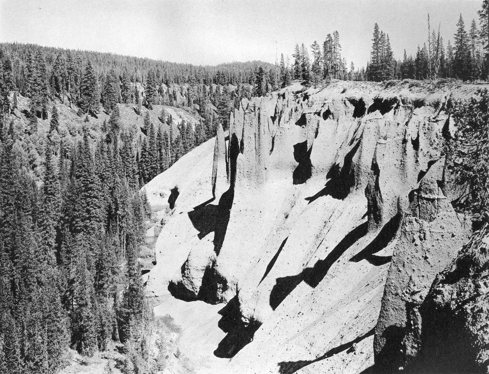
Plate 16. The Pinnacles, Sand Creek canyon, showing pale pumice flow beneath smoke-gray scoria flow, above which lie 10 feet of fine ash. Near the contact of the ash and scoria layers is the red zone caused by oxidation of iron-bearing fumarole gases. The pinnacles result from erosion controlled partly by vertical joints and partly by local compaction of scoria by hot gases. (Photograph by George Grant, National Park Service.) |
***previous*** — ***next***