
Soil Survey of Crater Lake National Park, Oregon
How to Use This Soil Survey
How to Use This Soil Survey
General Soil Map
The general soil map, which is a color map, shows the survey area divided into groups of associated soils called general soil map units. This map is useful in planning the use and management of large areas. To find information about your area of interest, locate that area on the map, identify the name of the map unit in the area on the color-coded map legend, then refer to the section General Soil Map Units for a general description of the soils in your area.
Detailed Soil Maps
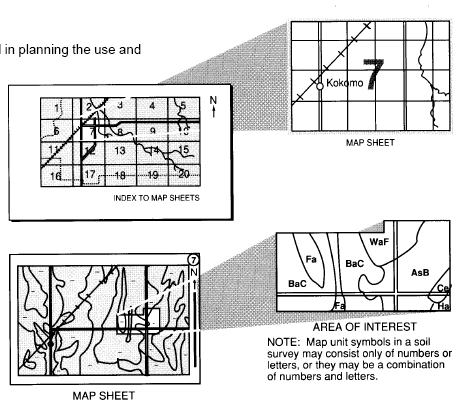
The detailed soil maps can be useful in planning the use and management of small areas.
To find information about your area of interest, locate that area on the Index to Map Sheets. Note the number of the map sheet and turn to that sheet.
Locate your area of interest on the map sheet. Note the map unit symbols that are in that area. Turn to the Contents, which lists the map units by symbol and name and shows the page where each map unit is described.
The Contents shows which table has data on a specific land use for each detailed soil map unit. Also see the Contents for sections of this publication that may address your specific needs.
Additional information about the Nation’s natural resources is available on the Natural Resources Conservation Service home page on the World Wide Web. The address is http://www.nrcs.usda.gov (click on “Technical Resources” ). This soil survey is a publication of the National Cooperative Soil Survey, a joint effort of the United States Department of Agriculture and other Federal agencies, State agencies including the Agricultural Experiment Stations, and local agencies. The Natural Resources Conservation Service (formerly the Soil Conservation Service) has leadership for the Federal part of the National Cooperative Soil Survey.
Major fieldwork for this soil survey was completed in 1999 through 2001. Soil names and descriptions were approved in 2001. Unless otherwise indicated, statements in this publication refer to conditions in the survey area in 2001. This survey was made cooperatively by the Natural Resources Conservation Service and the National Park Service.
Soil maps in this survey may be copied without permission. Enlargement of these maps, however, could cause misunderstanding of the detail of mapping. If enlarged, maps do not show the small areas of contrasting soils that could have been shown at a larger scale.
The United States Department of Agriculture (USDA) prohibits discrimination in all of its programs on the basis of race, color, national origin, gender, religion, age, disability, political beliefs, sexual orientation, and marital or family status. (Not all prohibited bases apply to all programs.) Persons with disabilities who require alternative means for communication of program information (Braille, large print, audiotape, etc.) should contact the USDA’s TARGET Center at 202-720-2600 (voice or TDD).
To file a complaint of discrimination, write USDA, Director, Office of Civil Rights, Room 326W, Whitten Building, 14th and Independence Avenue SW, Washington, DC 20250-9410, or call 202-720-5964 (voice or TDD). USDA is an equal opportunity provider and employer.
Additional information about the Nation’s natural resources is available on the Natural Resources Conservation Service home page on the World Wide Web. The address is http://www.nrcs.usda.gov. This soil survey is a publication of the National Cooperative Soil Survey, a joint effort of the United States Department of Agriculture and other Federal agencies, State agencies including the Agricultural Experiment Stations, and local agencies. The Natural Resources Conservation Service (formerly the Soil Conservation Service) has leadership for the Federal part of the National Cooperative Soil Survey.