
Classification of the Soils
Timbercrater Series
Depth class: Very deep
Drainage class: Excessively drained
Permeability: Very rapid
Position on landscape: Mountain flanks and mountainsides
Parent material: Pumice and ash (fig. 14)
Slope range: 0 to 80 percent
Elevation: 5,000 to 8,900 feet
Average annual precipitation: 40 to 70 inches
Average annual air temperature: 38 to 42 degrees F
Frost-free period: 0 to 50 days
Taxonomic class: Ashy-pumiceous, amorphic Typic Vitricryands
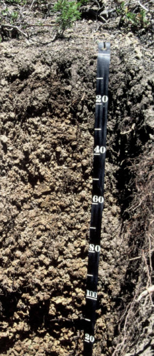
Figure 14.—Typical profile of a Timbercrater soil. Fragments are paragravel-sized pumice. Measurements on tape are in centimeters.
Typical Pedon
Oi—0 to 2 inches; slightly decomposed needle litter; abrupt smooth boundary.
A—2 to 5 inches; dark brown (10YR 3/3) paragravelly ashy loamy sand, brown (10YR 4/3) dry; weak fine granular structure; loose, nonsticky and nonplastic; many very fine, fine, and medium roots; many fine interstitial pores; 25 percent pumice gravel and 5 percent andesite gravel; moderately acid (pH 5.9); clear smooth boundary.
Bw—5 to 16 inches; brown (10YR 4/3) very paragravelly ashy loamy sand, yellowish brown (10YR 5/4) dry; weak fine subangular blocky structure parting to single grain; loose, nonsticky and nonplastic; common very fine, fine, and medium roots; many fine interstitial pores; 50 percent pumice gravel; slightly acid (pH 6.3); clear wavy boundary.
C1—16 to 20 inches; yellowish brown (10YR 5/6) extremely paragravelly ashy sand, brownish yellow (10YR 6/6) dry; single grain; loose, nonsticky and nonplastic; many very fine and fine roots and common medium roots; many fine and medium interstitial pores; 90 percent pumice gravel with yellow (10YR 7/6) interior; moderately acid (pH 6.0); clear wavy boundary.
C2—20 to 62 inches; brownish yellow (10YR 6/6) extremely paragravelly ashy sand, yellow (10YR 7/8) dry; few medium roots; 85 percent pumice gravel with very pale brown (10YR 8/4) interior; moderately acid (pH 6.0).
Typical Pedon Location
Map unit in which located: Timbercrater-Castlecrest-Llaorock complex, 10 to 30 percent south slopes
Location in park: About 3.1 miles south and 3.7 miles west of the northeast corner of Crater Lake National Park; 575586 meters easting and 4765875 meters northing, UTM Zone 10T, NAD 27; lat. 43o2’36.93″ N., long. 122o4’23.42″ W.
Range in Characteristics
Profile:
Depth to bedrock—more than 60 inches
Thickness of solum—14 to 25 inches
Average content of pararock fragments—35 to 80 percent
A horizon:
Value—2 or 3 moist, 3 to 5 dry
Chroma—2 or 3 moist or dry
Texture—paragravelly ashy sandy loam and paragravelly ashy loamy sand
Content of pumice gravel—15 to 35 percent
Content of andesite gravel—0 to 10 percent
Bw horizon:
Value—3 or 4 moist, 4 or 5 dry
Chroma—3 or 4 moist or dry
Content of pumice gravel—20 to 60 percent
C horizon:
Value—3 to 6 moist, 4 to 8 dry
Chroma—4 to 8 moist or dry
Texture—ashy sand or ashy loamy sand
Content of pumice gravel—70 to 95 percent
***previous*** — ***next***