
Formation of the Soils
Relief
The stability of the parent material in which a soil is forming is significantly influenced by the steepness of the slope. The stability or instability of sloping landscapes effects the rate at which a soil forms. Ridgetops, benches, and nearly level valley floors have stable slopes, and the soils exhibit stronger soil development. As the landscapes become steeper, soil development is more weakly expressed. This lack of development can be attributed to the colluvial action produced by gravity and water erosion, which mixes the soil layers. Because of the instability of the very steep inner caldera wall, very little soil has formed or accumulated on the wall. Consequently, soil and vegetation are noticeably absent except in concave areas and in areas of landslide material.
Old valley glacier sidewalls are throughout the park. Well-preserved classic U-shaped valley sidewalls are on the southern side of Mount Mazama. Scattered cliffs and buttes that are remnants of glacial valleys are primarily on the northern side of the mountain. All of the glacial valleys were filled with volcanic ejecta during later eruptions of Mount Mazama. These steep, unstable sidewalls are similar to the inner caldera walls, and soil development is weakly expressed.
The lava flows on the flanks of the older volcanoes, such as Union Peak and Timber Crater, have slopes that average about 10 percent. Icecap glaciation has eroded the slopes into a pattern of small rock hummocks that average 10 to 30 feet high and ash-filled depressions. The rock hummocks and depressions are elongated downslope. The ash was deposited in the low areas during the many eruptions of Mount Mazama and nearby volcanoes since the icecaps melted. This landscape is relatively stable. Castlecrest soils formed in the depressions, and Llaorock soils formed on the colluvial sides of the hummocks.
Glacial remnants that escaped burial by ashfall and ashflow deposits are on a few ridges near the western and southern boundaries of the park. Some of the oldest soils in the park, including the Grousehill and Oatman soils, are on these broad, very gently rolling ridges. These landscapes and soils have had about 15,000 to 25,000 years to form since the icecaps melted.
The slopes of Mount Mazama are a combination of glacial valley sidewalls, rock outcroppings, and ashflows. The pyroclastic flow deposits tend to be in stable positions on gently sloping side slopes, benches, and nearly level valley bottoms. During the eruptions, the steeper slopes were repeatedly blasted clean of pumice and ash. Unionpeak soils formed in gently sloping ashy material that was deposited while it was hot, resulting in a weakly cemented layer in the profile. Castlecrest soils, the most common soils in the park, formed in gently sloping to nearly level ashflows. Pyroclastic flows that are dominantly cobble-sized pumice fragments commonly are on nearly level to gently undulating flows. Umak and Maklak soils formed on these flows.
Cleetwood soils formed in sparsely vegetated deserts and meadows. These soils are gently sloping, but the unprotected ashy sand surface is subject to wind and water erosion.
Figures 15, 16, 17, and 18 show some of the major landscapes in the park, and they show the location of the major soils on those landscapes.
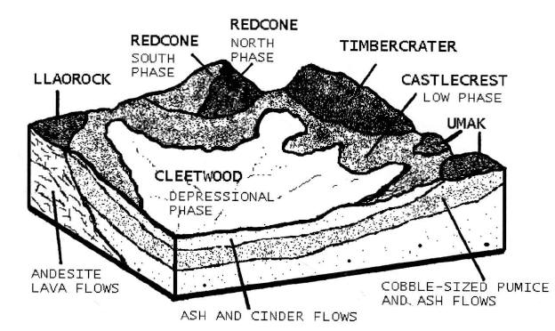
Figure 15.—Typical pattern of soils on pumice- and ash-covered uplands in the Pumice Desert area.
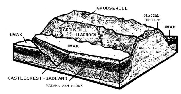
Figure 16.—Typical pattern of soils on pumice- and ash-mantled glaciated uplands along the western edge of the park.
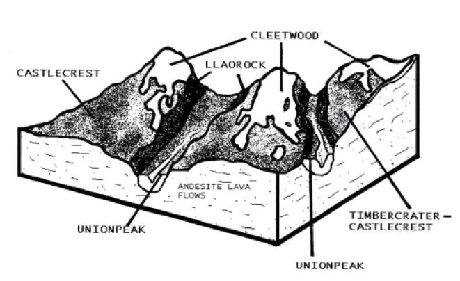
Figure 17.—Typical pattern of soils on ashflows in sedge- and grass-covered prairies and in valleys on the south slope of Mount Mazama.
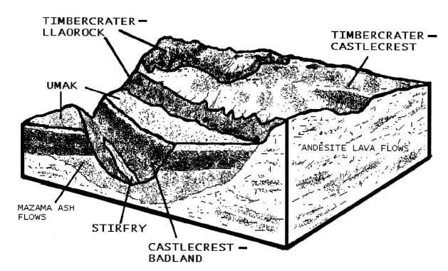
Figure 18.—Typical pattern of soils on pumice flows and pumice- and ash-covered uplands along Annie Creek, in the southeastern part of the park.
***previous*** — ***next***