
Cruise Report: R/V Surf Surveyor Cruise S1-00-CL, Mapping the Bathymetry of Crater Lake, Oregon, 2000
Introduction
During the Spring of 1999, the US Geological Survey (USGS) Pacific Seafloor Mapping Project (PSMP) was contacted by the US National Park Service Crater Lake National Park (CLNP) to inquire about the plausibility of producing a high-resolution multibeam bathymetric map of Crater Lake. The purpose was to generate a much higherresolution and more geographically accurate bathymetric map than was produced in 1959, the last time the lake had been surveyed. Scientific interest in various aspects of Crater Lake (aquatic biology, geochemistry, volcanic processes, etc.) has increased during the past decade but the basemap of bathymetry was woefully inadequate. Funds were gathered during the early part of 2000 and the mapping began in late July, 2000.
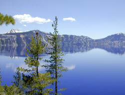
Crater Lake (Fig. 1) is located in south central Oregon (Fig. 2) within the Cascades Range, a chain of volcanoes that stretches from northern California to southern British Columbia. Crater Lake is the collapsed caldera of Mt. Mazama from a climatic eruption about 7700-yr ago (Nelson et al., 1988; Bacon and Lanphere, 1990; Bacon et al., 1997).
 |
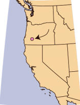 |
| Figure 1. Panoramic view of Crater Lake | Figure 2. Location of Crater Lake, Oregon (red circle). |
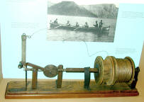
The floor of Crater Lake has only been mapped three times since the lake was first stumbled upon by gold prospectors in the 1853. The first survey was carried by out by William G. Steel during a joint USGS-US Army expedition under the direction of Maj. Clarence E. Dutton in 1886 (Dutton, 1889). Steel’s mapping survey collected 186 soundings using a Millers lead-line sounding machine (Fig.3). The resulting map (Fig.4) shows only soundings and no attempts were made to generate contours.
 |
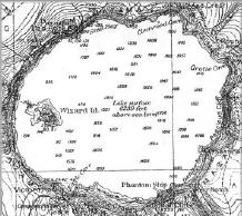 |
| Figure 3. Sounding machine used by Dutton’s 1886 expedition. | Figure 4. Map of soundings collected by Wm. Dutton’s 1886 expedition. Steel during the 1886 expedition. |
The second survey, conducted in 1959 by the US Coast and Geodetic Survey, mapped the bathymetry of Crater Lake with an acoustic echo sounder using radar navigation and collected 4000 soundings. The data were contoured by Williams (1961) and Byrne (1962) and the result is a fairly detailed map of the large-scale features of Crater Lake (Fig. 5). The third mapping survey, the one of this report, was a joint USGS-NPS project carried out under a Cooperative Agreement with the Center for Coastal and Ocean Mapping, University of New Hampshire. The 2000 survey used a Kongsberg Simrad EM1002 high-resolution multibeam mapping system owned and operated by C&C Technologies, Inc. of Lafayette, LA.
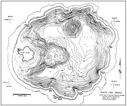 |
| Figure 5. Bathymetry of Crater Lake from 1959 Coast & Geodetic Survey Hydro Survey No. 8498. After Byrne (1961). |
***previous*** — ***next***