
Hydrology of Crater, East and Davis Lakes, Oregon by Kenneth N. Phillips
EAST LAKE
RECORDS OF LAKE LEVEL
Within the present century East Lake has fluctuated over a known range of about 16 feet, from 6,366 to 6,382.5 feet altitude. Data on its level are fragmentary (table 10). In any given calendar year, the observed fluctuation in water level has not exceeded 2 feet. The rather small annual fluctuation in stage is due to the lack of surface streams tributary to the lake, the rather close balance between annual precipitation and evaporation, and the apparently low rate of seepage loss.
| TABLE 10.-Altitude of water surface in East Lake |
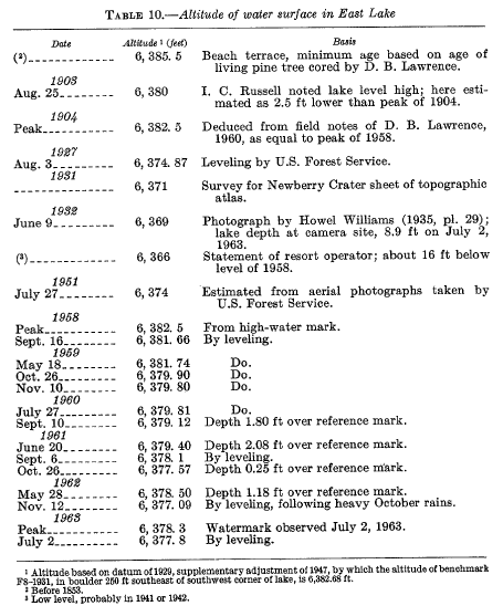 |
The earliest known reference to the water level of East Lake was recorded by Russell (1905, p. 101), who visited the lake August 25, 1903. Russell stated:
Like many enclosed lakes, it bears evidence of considerable fluctuations in level, the most conspicuous of which is a grove of dead spruce trees near its western shore which rise from about 3 feet of water. The trees are about 30 feet high, 10 to 12 inches in diameter, stand erect and still retain their branches. There is no indication that they were carried into the lake by a landslide, but every probability that they grew where they now stand and were killed by a rise of the lake which submerged the surface in which they were rooted.
A remarkable confirmation of Russell’s observation of a high lake level in 1903 was obtained in 1959 by D. B. Lawrence, of the University of Minnesota, who observed the stump of a lodgepole pine tree that had grown on a point of land at the northeast shore of East Lake, near Cinder Hill Forest Camp, and was living until cut down in 1957 or 1958. Lawrence stated in his field notes (written commun., 1963):
Symmetry of its central rings from time of germination about 1870 to 1904 showed that it had grown erect as a member of a dense forest there during that period. Erosion by high water apparently occurred about 1904, removing support from about half of the root system, allowing the tree to tilt strongly toward the north. The tree continued to grow, producing asymmetrical rings, wide on the lower side. The high water of 1958 seems to have reached about the same level as that which caused the erosion that resulted in tilting about 1904 or 1905.