
Hydrology of Crater, East and Davis Lakes, Oregon by Kenneth N. Phillips
CRATER LAKE
PHYSIOGRAPHIC AND GEOLOGIC SETTING
Crater Lake (fig. 2), the deepest lake in the United States, lies in the caldera of Mount Mazama, an extinct volcano that rises on the crest of the Cascade Range in southern Oregon, 120 miles inland from the Pacific Ocean. The lake is 41½2 to 6 miles in diameter and 1,932 feet deep. Its water surface is about 6,175 feet above mean sea level. The walls of the caldera descend steeply into the water, so that an observer on the rim above may see the narrow fringe of green shallow water near the shore merging within a short distance into the intense blue color of great depth. The lake has no surface outlet and no perennial inflowing streams.
‘Crater Lake has a surface area of 20.53 square miles (13,140 acres) at altitude 6,176 feet. The area between the encircling rim and the lake is 5.17 square miles, and Wizard Island, a volcanic cone rising 770 feet above the water surface, covers 0.47 square mile. The lake contains about 14 million acre-feet (4.2 cubic miles) of water. That volume represents 150 times the present average annual water supply. The water level has fluctuated about 16 feet.
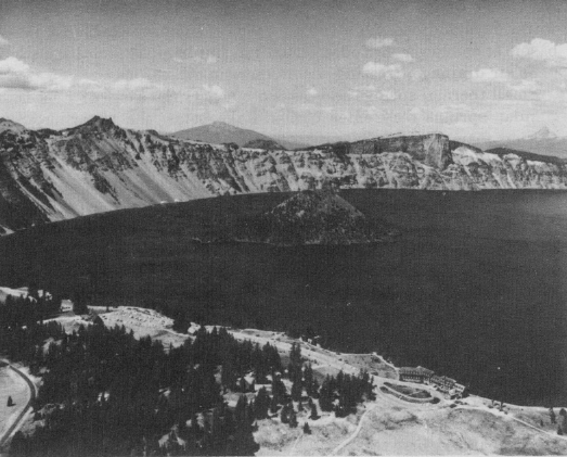 |
| Figure 2.-Western half of Crater Lake, view looking northward toward Mount Thielsen (right skyline). Wizard Island (center) is a volcanic cone that was formed within the caldera before the lake had attained its present height. (Oregon State Highway Dept. photograph 6639.) |
A bathymetric survey in 1959 (fig. 3) disclosed a, rather flat lake floor more than 1,500 feet below the water surface, from which a conical hillock (Merriam Cone) rises to within 500 feet of the surface. The lake has a depth of at least 1,920 feet over an area of 1.0 square mile.
In places, the soil cover -of the steep slopes around the shores of the lake has been removed -by landslides or avalanches; elsewhere, a moderately dense stand of pines, firs, and poplars covers the slopes down to the edge of the lake. When the lake is at a low stage, seedlings may be found growing below recent high-water levels, and Nelson (1961, p. 30) cited a report of the discovery in 1956 of the stump of a tree that may either have grown at altitude 6,129 feet or have been carried to that level by a local landslide. There are no confirmed reports of large trees having grown below about 6,178 feet, or of any trees below altitude 6,165 feet.