
Hydrology of Crater, East and Davis Lakes, Oregon by Kenneth N. Phillips
HYDROLOGIC AND CHEMICAL DATA
| TABLE 1.-Monthly and annual temperature and precipitation at Crater Lake I |
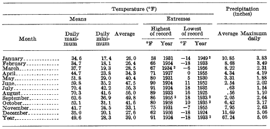 |
1 Average and extreme temperatures and precipitation are based on 27 years of complete records in the period 1924-61. Data furnished by U.S. Weather Bureau from station at park headquarters, 2 miles south of Crater Lake rim.
2 Also in other years.
| TABLE 2.-Precipitation, in inches, at Crater Lake Weather Station for years ending June S0, 1981-62 1 |
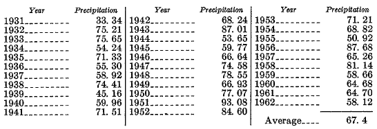 |
1 Records for August 1930 observed at south rim of Crater Lake, altitude 7,086 feet; records for July, September, and October 1930 estimated for this report. From November 1930 through 1962, precipitation station has been at altitude 6,475 feet. Records for most months, November 1942 to June 1946, were estimated by U.S. Weather Bureau using correlation techniques.
| TABLE 3.-Rise in level of Crater Lake in selected periods of heavy precipitation, 1961-62 |
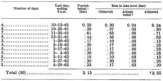 |
1 From records of U.S. Weather Bureau.
2 Adjustment applied to change in lake stage to compensate for tributary inflow estimated at 14 cfs (equivalent to 0.002 ft depth per day on lake surface) and outflow by seepage at 89 cfs (equivalent to 0.0134 ft per day on the lake surface).
3 Ratio of total adjusted changes in lake level to total precipitation is 1.07.
| TABLE 4.-Fall in level of Crater Lake in selected periods of no precipitation, 1961-62 |
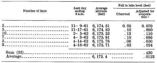 |
1 Evaporation rate of 0.002 foot per day assumed.