
From 1951 to 1960, attempts were made to increase winter precipitation and summer runoff in the adjacent basins of Rogue, Umpqua, and Klamath Rivers by cloud seeding in periods thought to be favorable for that purpose. These attempts produced no statistically significant results in streamflow (Calvin and Peterson, 1960, p. 3) and probably did not change significantly the water supply of Crater Lake.
Information on evaporation loss from Crater Lake is scanty. In 1901, Diller made the only known attempt to measure evaporation (Diller and Patton, 1902, p. 58). Diller used (1) a brown floating pan, 13 by 13 inches by 6 inches deep, (2) a similar land pan, and (3) a bright land pan of the same dimensions. In a 9-day period in mid-July, observations at the floating pan showed water loss at an average rate of 0.014 foot per day (4.9 in. per month). The land pans showed considerably more loss. All his tests were of short duration, and none was made with equipment that meets present standards.
Evaporation has been measured from a 4-foot-diameter floating pan at Lake Tahoe, about 265 miles south of Crater Lake, at an altitude of 6,230 feet on the eastern slope of the Sierra Nevada. For the period May 1 to October 31, the average evaporation loss there is 25.8 inches (Blaney and Corey, 1955, table 44), and the average annual evaporation loss has been estimated at 3.07 feet (Harding, 1965, p. 20).
Evaporation has also been measured from a land pan at Odell Lake, 42 miles north of Crater Lake, at an altitude of about 4,800 feet on the eastern slope of the Cascade Range (table 11). The average evaporation loss from May 1 to October 31 is 19.3 inches, and the average for the year is estimated at 24 inches. The corresponding loss from an open water surface would be somewhat less.
The evaporation loss from Crater Lake in the period May to October is probably less than, at Lake Tahoe, because Crater Lake lies 265 miles farther north and in a much more humid climate. Odell Lake is lower than Crater Lake but has comparable annual precipitation. On the basis of comparative latitude, altitude, and annual precipitation, the evaporation loss from Crater Lake is probably similar to or less than that of Odell Lake.
At Medford, 46 miles southwest of Crater Lake, evaporation has been measured for 24 years (U.S. Weather Bureau, 1962, p. 231). The Medford Weather Station is the only one that is situated on or near the path of most of the airmasses that pass over Crater Lake and has records for the entire year over a long period. The precipitation and relative humidity at Medford are lower, and the average temperature is higher, than at Crater Lake. At Medford, the average annual evaporation loss from a class A land pan at altitude 1,457 feet is 44.8 inches, of which 79 percent occurs in the period May to October.
Relatively high humidity prevails at Crater Lake from November to April, so that probably not less than 80 percent of the total annual evaporation loss there occurs in the period May to October. For this report no attempt was made to ascertain evaporation loss at Crater Lake by direct measurement of evaporation or of the factors that influence it. Rather, annual evaporation loss is considered to be the residual after the loss by seepage has been deducted from the annual water supply (see p. E20). Therefore, any error in ascertaining precipitation, inflow, or seepage introduces an error of like amount in the computed evaporation loss.
| TABLE 1.-Monthly and annual temperature and precipitation at Crater Lake I |
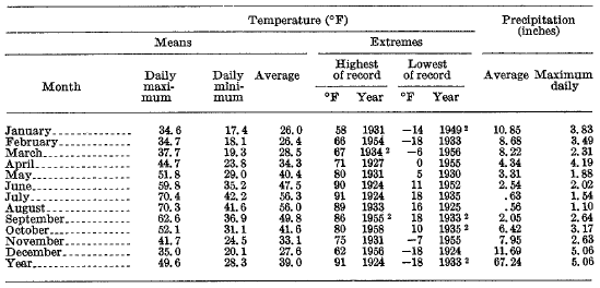 |
1 Average and extreme temperatures and precipitation are based on 27 years of complete records in the period 1924-61. Data furnished by U.S. Weather Bureau from station at park headquarters, 2 miles south of Crater Lake rim.
2 Also in other years.
***previous*** — ***next***