
Hydrology of Crater, East and Davis Lakes, Oregon by Kenneth N. Phillips
EAST LAKE
PHYSIOGRAPHIC AND GEOLOGIC SETTING
East Lake is a small body of fresh water in southern Deschutes County (fig. 1). It occupies the eastern part of Newberry Crater, a volcanic caldera nearly 5 miles in diameter. The western part is occupied by the slightly larger and lower Paulina Lake. The two lakes are separated by a barrier of subsidiary volcanic cones and lava flows of Holocene age that form a ridge about 1.2 miles wide and divide the caldera near the middle along a north-south line (fig. 6).
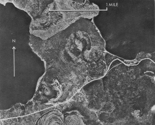 |
| Figure 6.-Part of Newberry Crater; view showing cinder cones and lava flow separating East Lake (right) from Paulina Lake. Photograph by U.S. Forest Service, July 27,1951. |
The crater rim rises steeply for several hundred feet around both lakes to altitudes of 7,000 feet or more, except where Paulina Lake has breached the rim to form a perennial outlet to Deschutes River basin by way of Paulina Creek.
East Lake has a surface area of 1,030 acres at high level and 940 acres at average level. Its maximum depth is about 170 feet. The part of the caldera surrounding and topographically tributary to East Lake covers 7.46 square miles, including the lake itself. The lake has a volume at high level of about 68,000 acre-feet. The volume within the historic range of observed water level is about 15,000 acre-feet.
The hydrology of East Lake cannot be studied without also considering Paulina Lake, which is closely associated with it. Paulina Lake covers 2.10 square miles and has a maximum depth of 252 feet. The water surface ranges from 6,330 to 6,333 feet in altitude and has continuous outflow. The entire area of Newberry caldera (17.5 square miles including East Lake and its basin) is topographically tributary to Paulina Lake. East Lake basin, however, seems to be a hydraulically separate entity.
East Lake is 40 to 50 feet higher than Paulina Lake. The hydraulic gradient of 35 to 42 feet per mile from East Lake to Paulina Lake is greater than is normally observed in recent lava flows; hence it is inferred that the blocky lava flow near the north end of the separating ridge is underlain by less permeable cemented deposits. Such deposits may be seen near the southeastern shore of East Lake and along the eastern shore of Paulina Lake, and extend from levels lower than the lake surfaces to levels well above them.
Surrounding East Lake is a forest cover of a type common in high mountain areas of Oregon where precipitation is moderate. Lodgepole pine trees grow abundantly from the edge of the lake up to the caldera rim, yellow pines are scattered on the steep slopes, and some hemlocks and alders are present.