
Hydrology of Crater, East and Davis Lakes, Oregon by Kenneth N. Phillips
DAVIS LAKE
WATER LOSS FROM THE LAKE
EVAPORATION LOSS
Evaporation at Davis Lake is probably a little less than at Wickiup Dam, 10 miles to the northeast, where the average loss from a class A land pan has been measured as 34.09 inches in the period May to September (table 11). The average annual evaporation loss from the surface of Wickiup Reservoir is probably about 32 inches, and that from Davis Lake is estimated at 30 inches for this report. The volume of that loss depends upon the stage and surface area of the lake during the summer season. That area ranges from 470 acres at altitude 4,378 feet to 3,670 acres at altitude 4,391 feet. The lake area is usually greater in the summer evaporation season than in the winter precipitation season; hence, an average annual evaporation loss of 30 inches may fully offset an infalling precipitation increment of 36 inches. In any event, the average evaporation loss is less than 10 percent of the total water supply.
| TABLE 11. Monthly and annual average temperature, precipitation, and evaporation at Odell Lake I and Wickiup Dam, I near Davis Lake |
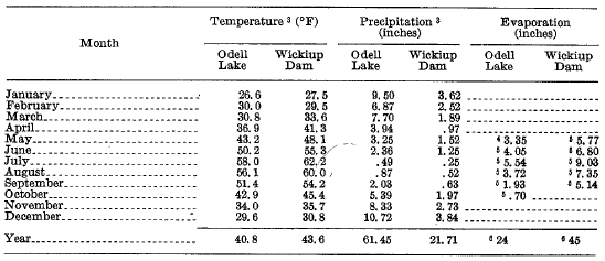 |
1 Weather station altitude, 4,795 ft.
2 Weather station altitude, 4,358 ft.
3 From records of U.S. Weather Bureau for the period January 1950 to December 1964, not adjusted to long-term average.
4 Average of land-pan values for May 1951-63.
5 Normal evaporation from land pans (records of U.S. Weather Bureau).
6 Estimated for this report.
***previous*** — ***next***