
Hydrology of Crater, East and Davis Lakes, Oregon by Kenneth N. Phillips
CRATER LAKE
WATER SUPPLY TO THE LAKE
PRECIPITATION ON THE LAKE
The lake covers 20.53 square miles of the 26.17-square-mile total drainage area. The peripheral tributary area is subject to some loss of water by evapotranspiration; hence, precipitation falling directly into the lake must account for more than 78 percent of the total water supply. It is therefore desirable to measure that precipitation as accurately as possible.
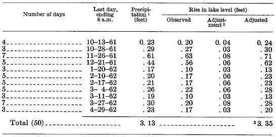
The response of lake level to heavy precipitation provides a clue to the relationship of observed precipitation at the weather station to that over the lake itself. In table 3, records of heavy precipitation in 1961-62 are compared with records of lake level. In the 50 days studied (table 3), more than 60 percent of the total precipitation for the entire water year ending September 30 occurred. For these humid periods, loss by evaporation is disregarded, and outflow seepage is assumed to be steady at 89 cfs, as ascertained for periods of no precipitation in 1961-62 (p. E17). Although most of the precipitation was in the form of snow, the average inflow from the tributary area is assumed to be equivalent to 14 cfs (0.002 ft per day on the lake area), about 3 percent of the total supply for these wet periods.
For a total observed precipitation of 3.13 feet in 50 days, the lake response (adjusted for inflow and seepage) was 3.35 feet, or 7 percent more than the total precipitation observed at the weather station. The difference in periods of high wind may be due to under-registering of precipitation that fell as, snow at the weather station, or to snow drifting over the rim into the lake, or to avalanching of accumulated snow into the lake during the storms. The relationship between measured precipitation and lake-level rise varied in different storms.
Annual precipitation at the weather station, summarized in table 2, has been totalized for the years ending June 30, 1931-62, to facilitate comparisons with observations of lake level, which are generally available only for the summer. The average observed annual precipitation in the 32-year period is 67.4 inches, and in the same period the average precipitation inside the lake rim is computed as 67.4 x 1.07, or 72 inches. This was not a normal or equilibrium period-in fact, the lake level in the summer of 1962 was about 8.7 feet higher than in 1930. Adjustment for storage in the lake during this period reduces the average long-term annual precipitation on the lake from 72 to 69 inches, and that at the weather station from 67.4 (1930-62) to about 64.8 inches.
| TABLE 2.-Precipitation, in inches, at Crater Lake Weather Station for years ending June S0, 1981-62 1 |
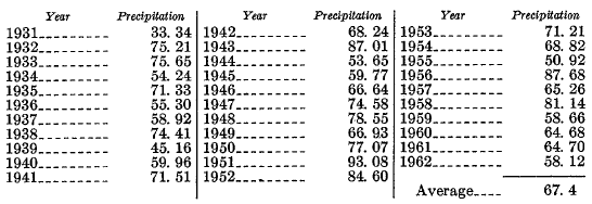 |
1 Records for August 1930 observed at south rim of Crater Lake, altitude 7,086 feet; records for July, September, and October 1930 estimated for this report. From November 1930 through 1962, precipitation station has been at altitude 6,475 feet. Records for most months, November 1942 to June 1946, were estimated by U.S. Weather Bureau using correlation techniques.
| TABLE 3.-Rise in level of Crater Lake in selected periods of heavy precipitation, 1961-62 |
 |
1 From records of U.S. Weather Bureau.
2 Adjustment applied to change in lake stage to compensate for tributary inflow estimated at 14 cfs (equivalent to 0.002 ft depth per day on lake surface) and outflow by seepage at 89 cfs (equivalent to 0.0134 ft per day on the lake surface).
3 Ratio of total adjusted changes in lake level to total precipitation is 1.07.
***previous*** — ***next***