
Klamath Network Water Quality Report (Phase II)
Section 2: Locations of Active Monitoring Stations in the Klamath Network Region
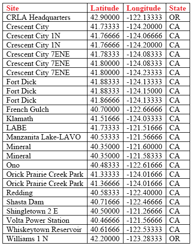
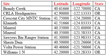
Tables 2-7 list the locations of geo-referenced climatic and hydrologic monitoring stations in or near Klamath Network park units. In addition to these monitoring stations, past water quality sampling sites in or near Lassen, Lava Beds, Oregon Caves and Whiskeytown are listed in a Horizon Report for each park unit (i.e., LAVO = NPS-WRD 1999a, pages 51-54; LABE = NPS-WRD 1999b, page 39; ORCA = NPS-WRD 1998, page 45; WHIS = NPS-WRD 2000, pages 45-47). Horizon Reports have not been completed for Crater Lake and Redwoods. The Horizon Reports are baseline water quality data inventories that detail historical water quality sampling and monitoring efforts in network park units. These reports have been developed by the National Park Service Water Resources Division and Service-wide Inventory and Monitoring Program. The network will emphasize verifying and geo-referencing additional locations and will link spatial files with corresponding tabular records in the NPS database for cataloging datasets and related metadata.
| TABLE 2: Daily Precipitation Monitoring Stations as of 2005 in the Klamath Network Region |
 |
| TABLE 3: Hourly Precipitation Monitoring Stations as of 2005 in the NPS Klamath Region |
 |