
Klamath Network Water Quality Report (Phase II)
Section 3: Past Inventory, Monitoring, and Research Activities in the Klamath Network Park Units
| Crater Lake National Park (CRLA) |
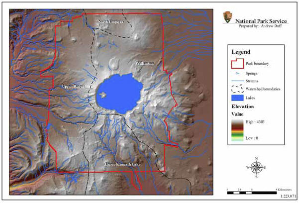 |
| FIGURE 3: Aquatic Resources and Watershed Boundaries of Crater Lake National Park, Oregon, NPS Klamath Network |
General Summary of Past Activities: Crater Lake National Park has focused primarily on monitoring the water quality of Crater Lake. A long-term lake monitoring program has been active since 1983. Less comprehensive water quality inventories have been completed for ponds/lakes and streams located outside of the Mt. Mazama caldera. A Sun Creek bull trout restoration project and a survey of amphibians in the Whitehorse Ponds have also been initiated and/or completed.
Crater Lake National Park (Figure 3) was established by Presidential Proclamation on May 22, 1902. The 74,140 ha (182,304 ac) park is located at the southern end of the Cascade Mountains in south-central Oregon. The park is dominated by a large natural caldera lake formed after the eruption of Mt. Mazama, approximately 7700 years ago (Ramsey et al. 2003; accessed June 6, 2005 at http://geopubs.wr.usgs.gov/imap/i2790/i2790.pdf). The lake that is now in existence usually fluctuates seasonally between 1881 and 1882 m (573 – 574 ft) in surface elevation. However, fluctuations of up to five meters have been recorded (Redmond 1990). Crater Lake is the clearest and seventh deepest lake (592 m, 1942 ft) in the world, and has a strikingly deep blue color. Secchi disk clarity readings have been recorded as deep as 40 m (131 ft).
The water quality of Crater Lake and other freshwater resources in Crater Lake National Park has been an important management focus for over 100 years. Water quality monitoring of Crater Lake began in 1892 when Diller and Patton initiated the recording of Crater Lake water level (Larson 1987). Numerous inventory, monitoring, and research projects and programs have been completed or are being conducted within the caldera and focused on Crater Lake, or at sites located outside of the caldera.
Intra-Caldera Monitoring and Research
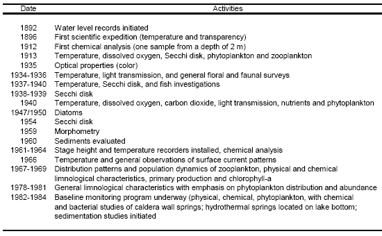
Monitoring and research activities from 1892-1984 that were designed to document the physical, chemical, and biological characteristics of Crater Lake are listed in Table 8. Most of these activities were of short duration and limited in scope (Larson 1987). A long-term Crater Lake water quality monitoring program, that is now 22 years old, was initiated in June 1983. Sampling has been most often conducted during July, August, and September, however, sampling also has been conducted in January, March, April, May, June, and October. Samples for the determination of lake water quality have been collected at predetermined depths from 0–550 m, and from intra-caldera springs (Larson 1987, 1990, 1996). Initially, up to 41 springs were sampled, but this number was reduced to five springs beginning in 1990. Water quality variables monitored as part of the longterm monitoring program (1983-present) are listed in Table 9. Introduced rainbow trout (Oncorhynchus mykiss) and kokanee salmon (Oncorhynchus nerka) have also been studied as part of the monitoring program. Detailed information concerning the long-term water quality monitoring program is available in Larson 1987, 1990, and 1996.
| TABLE 8: Highlights of Crater Lake Monitoring and Research Activities, 1892-1984 (from Larson 1987) |
 |