
Klamath Network Water Quality Report (Phase II)
Section 3: Past Inventory, Monitoring, and Research Activities in the Klamath Network Park Units
| Lassen Volcanic National Park (LAVO) |
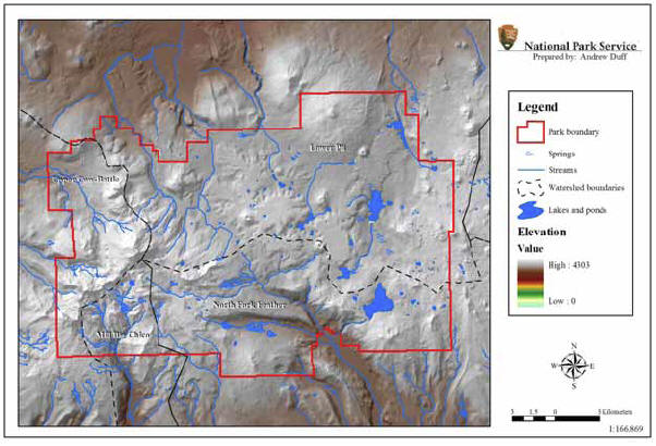 |
| FIGURE 4: Aquatic Resources and Watershed Boundaries of Lassen Volcanic National park, California, NPS Klamath Network |
General Summary of Past Activities: Surveys of Lassen Volcanic National Park ponds/lakes, wetlands and streams have focused primarily on documenting baseline ecological condition and developing management and research alternatives for these resources. The status of aquatic invertebrates, native amphibians and nonnative fish in Lassen lentic habitats has also been documented. Hydrothermal/geothermal resources have been continuously monitored since 1981, focusing on water quality characteristics, potential impacts of these resources on visitors, and potential visitor impacts on the resources.
Lassen Peak and Cinder Cone National Monuments were established on March 6, 1907, and combined into Lassen Volcanic National Park (Figure 4) on August 9, 1916. The park is located in the southern most part of the Cascade Mountains in northeastern California, and is part of the Cascade Physiographic Province. The park is 43,047 ha (106,372 ac) in size, and the landscape is dominated by volcanic processes; Lassen Peak is the southernmost volcano in the Cascade Range. The park contains up to 277 permanent and ephemeral lentic water bodies. Portions of five drainage basins are located within the park, and four of the drainage basins (about 99% of the park) drain into the Sacramento River. Many lakes have been historically stocked with nonnative trout for recreational fishing and now contain self-propagating populations. Mill Creek, which has no dams blocking anadromous fish passage, is one of very few stream courses remaining in the Sacramento River drainage with biological integrity preserved.
There are several aquatic vertebrate and invertebrate taxa within Lassen that are on the federal and/or state lists as protected species. Kings Creek caddisfly (Parapsyche extensa) is a federal species of concern; the Modoc sucker (Catostomus micorps) is listed as endangered on both lists; and the Cascades frog (Rana cascadae) is listed as a federal and state species of concern.
Horizon Report
The retrieval of surface water quality data from six of the US Environmental Protection Agency’s (EPA) national water resources databases included data generated by four agencies (i.e., National Park Service [NPS], US Geological Survey [USGS], EPA, and California Water Resources Control Board [CWRCB]; NPS-WRD 1999a). These data represent water quality analyses for samples collected from 281 sampling stations, of which 218 (NPS = 190, USGS = 14, EPA = 7, CWRCB = 7) were within the boundaries of Lassen. Park sampling stations (NPS-WRD 1999a, pages 51-54) were located at 29 lakes, 21 cold and hot streams, 60 hydrothermal sites, and 2 wetlands. Some sites had multiple sampling stations. A total of 169 water quality parameters (NPS-WRD 1999a, pages 55-57) were examined, although not all parameters were represented at all sampling locations. The period of time represented by these data from Lassen sampling sites was 1960-1994. The Horizon Report is available at: (http://nrdata.nps.gov/LAVO/nrdata/water/baseline_wq/docs/LAVOWQAA.pdf).