
Temperatures of springs in the vicinity of Crater Lake, Oregon, in relation to air and ground temperatures by Manuel Nathenson, 1990
AIR AND GROUND TEMPERATURES
Air temperatures for weather stations in an area of 30 longitude by 20 latitude are given in Table 1. Locations of the weather stations are shown on Figure 1, and temperatures are plotted versus elevation in Figure 2. These values are for a 30 year period and should be relatively stable. The area covered by these stations is relatively large, ranging from the Coast Range through the Cascade Range and into the Basin and Range. Stations from a large area are necessary to get an adequate range of elevations. Figure 2 shows that at each elevation there is a significant range of average annual temperatures, but it appears reasonable to fit a best straight line to the data. Using temperature as the dependent coordinate, the line has a slope of -4.6±0.40C/km and an intercept of 13.2±0.50C at sea level elevation (± values are standard error). The value for lapse rate is smaller in absolute value than that found by Bodell and Chapman (1982) for the Colorado Plateau but is similar to the ground temperature lapse rate given by Delisle (1988) for wet climates.
A search was made to find drill hole data for calculating average ground temperatures for the same area. Data from many drill holes indicate either hydrologic disturbances or near-surface disturbances that are not easily understood. Data from seven drill holes were found to be used easily for extrapolation, and the results are given in Table 2 and plotted on Figures 1 and 2. The ground temperature data are more restricted areally and in elevation range because of the significant influence of hydrology on near-surface temperatures in the higher elevations of the Cascades (e.g. Black and others, 1983a). Unlike the results for the Colorado Plateau, the distribution of ground temperatures is generally similar to that for air temperatures (Figure 2). More data might show that this is somehow a biased sample; however, the larger data set of Powell and others (1988) has no ground temperatures cooler than mean annual air temperatures whereas 3 out of 7 in Figure 2 are cooler than the air temperature best fit line. It seems likely that the difference reflects a difference in climate between the Cascade Range and the Colorado Plateau and is not an artifact of the data set.
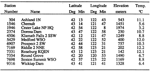 |
| Table 1. Mean annual temperatures from weather stations in the vicinity of Crater Lake (National Oceanic and Atmospheric Administration, 1982) |
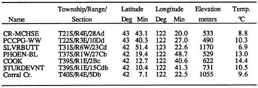 |
| Table 2. Ground temperatures for drill holes in the vicinity of Crater Lake obtained by projecting temperature versus depth to the surface. Data from Black and others (1983a, 1983b), Blackwell and others (1981, 1982, 1986), Hull and others (1977, 1978). |
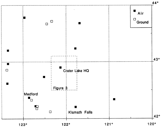 |
| Figure 1. Map of southern Oregon showing locations of weather stations, drill holes used to determine average ground temperatures, and outline of map of Figure 3. Names shown are for places near some of the weather stations. |
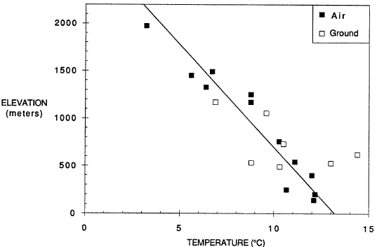 |
| Figure 2. Mean annual air temperatures and average ground temperatures versus elevation for locations given in Figure 1. Line shown is least-squares fit to air temperature versus elevation data. |
***previous*** — ***next***