
Crater Lake National Park Whitehorse Pond Limnological and Vascular Plant Study, 1993
1.0 INTRODUCTION
The study of the Whitehorse Pond Complex began in 1992 with the work of Roger Brandt (Brandt, 1992). Whitehorse ponds are located in Crater Lake National Park on Whitehorse Bluff just south of Highway 62 and west of the Pacific Crest Trail. From the top of the bluff one can see the highway. From the highway the bluff is seen above a one-hundred foot gray wall of rock to the south. The current study was initiated because of the author’s keen interest in both the Crater Lake environs as well as the quality of water in the High Cascades. His research proposal is included in Appendix I.
The White Horse Ponds are located on White Horse Bluff in Crater Lake National Park approximately 0.25 to 0.5 miles south and west of Highway 62. White Horse Bluff is a conspicuous outcrop of what appears to be andesitic lava achieving elevations of 6,300 to 6,350 feet national geodetic vertical datum (NGVD). Previous studies have identified 12 ponds (Brandt 1992). Some of the numbered ponds should be referred to as pond complexes, because more than one pond are associated with them. For example, Pond 7 includes four interconnected ponds. These ponds occupy topographic depressions in the lava with spill elevations two to four feet above the invert elevations of the pond bottoms. Ponds of only one to two feet of depth often become dry late in the summer, although the deepest ponds (e.g. Pond 3) remain inundated through most summers.
The Whitehorse pond area was visited five times during the summer of 1993. The author was accompanied on most trips by field researchers working in or around the Park on similar research. Studies included field and taxonomic observations of the flora surrounding the pond area, in situ aquatic monitoring of temperature, and pH. Grab samples included the collection water for the determination of dissolved oxygen, nutrient chemical concentrations, phytoplankton, and zooplankton. The chemical analyses were completed by the Cooperative Chemical Analytical Laboratory (CCAL) in Corvallis headed by Mr. Cameron Jones. This lab was established by memorandum of understanding no. PNW-82-187 between the USDA Forest Service and the Department of Forest Science, Oregon State University.
A survey of the flora in the Whitehorse ponds area was completed by Mr. David Hartesveldt. The observations documented in this report were limited by the single survey undertaken in August of 1993. The flora of Whitehorse Bluffs and, possibly, the ponds themselves, is almost certainly more diverse than is indicated in this report. Due to the varied phenology of the montane flora of Crater Lake, one field survey conducted late in the summer necessarily misses plants blooming earlier or later in the summer. No effort was made to collect or identify any of the various bryophytes (e.g. mosses and liverworts) associated with the White Horse Ponds. Yet, mosses were an important component of several ponds, particularly those which were dry at the time of the field survey. For a more complete understanding of the floristic relationships and successional processes of the White Horse Ponds, a more comprehensive floristic study of the ponds that includes the bryophytes would be warranted.
Eight ponds on White Horse Bluff, were sampled for zooplankton and phytoplankton. John Salinas collected 14 total samples, 11 zooplankton and 3 phytoplankton, during a period from July 14 through September 10, 1993. Mr. Robert Truitt analyzed pond water samples for phytoplankton and zooplankton.
This project also exposed students of Rogue Community College to field research. This was accomplished on the August 9th field day. About a dozen students recorded observations and collected pond samples for later analyses. Several of their reports are included in Appendix II.
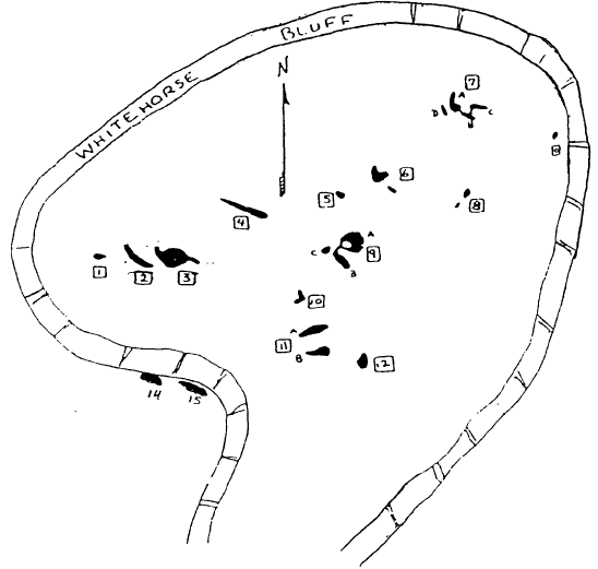
Roger Brandt’s pond numbering system was used to identify individual ponds (Figure 1). A shallow pond far to the east on the plateau was unnamed in Roger’s work and has been numbered Pond #0 in this report. A pond to the east of the Pond #9 complex has been called Pond #9 east or Pond #13. There also seem to be two ponds to the extreme southwest of the main pond group, these were called Ponds #14 and #15 and were not visited in this study. East of Ponds 10, 11, and 12 was another unnamed pond which was called Bear Tree pond because a bear had stripped a tree of its bark to about ten feet high.
Ground truthing of Roger’s map began as soon as this pond study began. Every effort was made to accurately document each sample with respect to pond location and name. However Roger’s map needs to be updated and each pond identified with a simple marker.
|
|
|
Figure I. A map of the Whitehorse Ponds at Crater Lake National Park. |
***previous*** — ***next***