
Ecology Of Elk Inhabiting
Crater Lake National Park And Vicinity
by Kurt Jenkins, Kevin Cooper, Edward Starkey
National Park Service Cooperative Park Studies Unit
College of Forestry, Oregon State University
Corvallis, OR 97331
CPSU/OSU 88-2
|
|

Introduction
Historically, Roosevelt elk (Cervus elaphus roosevelti) inhabited western Oregon from the Pacific Ocean to the Cascade Crest, including the area presently contained within Crater Lake National Park (CRLA). Early settlers in the western foothills and valleys of the Cascades were confronted with a seemingly endless supply of elk which they hunted excessively for hides, meat and teeth. By the late 1880’s the effects of unrestricted harvest were evident; elk populations were depleted in many areas throughout western Oregon and were reported to have disappeared altogether from the Crater Lake area (Harper 1985). In an effort to restore elk to the Oregon Cascades, they were completely protected from hunting at the turn of the century, and populations were later supplemented with Rocky Mountain elk from Yellowstone National Park. In 1917, 15 such elk were transferred to CRLA, and together with residual populations of native Roosevelt elk, they formed the nucleus for elk herds that presently summer within the park.
 Potential elk management problems in CRLA are common to relatively small parks that contain only a small fraction of the available annual range. Elk of CRLA cross several ownership boundaries in their annual movements. Consequently, they are exposed to diverse management practices which may influence population levels and distribution patterns. Forests on the west slope of the Cascades are managed intensively for wood-fiber production. Such management practices could have both beneficial and adverse effects on elk numbers, depending on cutting prescriptions, timing and spacing of cutting units, and factors relating to human disturbance (Witmer et al. 1985). Additionally, elk are subject to intensive sport hunting outside CRLA, which also could have variable influences on park elk depending on elk movement patterns in response to hunting seasons.Records of the reestablishment of elk to CRLA are incomplete. Elk herds were reported in the high Cascades within and adjacent to CRLA in 1929, specifically on Mount Scott, Mount McLoughlin, and in Red Blanket Canyon (Anon., 1929). By the late 1960’s, CRLA was believed to be visited each summer by a stable population of 50-75 elk. The first systematic surveys of elk during the 1970’s suggested that a minimum of 140-160 elk summered within the park (Manning 1974, Hill 1976). Landowners in the Fort Klamath area south of CRLA reported seeing 40-60 elk feeding in their pastures each spring in the 1950’s and 1960’s. However, 150 elk are now commonly counted during spring (John Toman, Pers. Comm.). Such information, though not well documented, suggests that the Crater Lake elk herd may have increased in the last decade.
The first step to enable park managers and scientists to interpret the effect of land management and hunting on elk is to determine population characteristics, seasonal movements, and habitat use patterns of park elk herds. Initially, the greatest need is for descriptive information as a basis for identifying important management areas for park elk, and for formulating and testing specific hypotheses for future research. The objectives of this research in CRLA were:
- to determine indices of herd sizes and composition,
- to describe elk seasonal movements, migratory routes, and seasonal ranges,
- to determine habitat use patterns of elk within and adjacent to the park.
Acknowledgments This research was conducted cooperatively by the National Park Service (NPS), Oregon Department of Fish and Wildlife (ODFW), the Klamath Indian Tribe, and the United States Forest Service (USFS), each of which shared a common interest in Crater Lake elk and their habitats. The National Park Service provided funding and personnel for this study through the Cooperative Park Studies Unit at Oregon State University. ODFW provided personnel, planning and materials for the construction of elk traps and the ensuing elk trapping efforts. Oregon State Police (OSP) provided pilots and aircraft for aerial radio-telemetry studies, the Klamath Indian Tribe provided radio-telemetry equipment, and the USFS and NPS provided housing. Individuals from each agency provided logistical support, as well as the benefits of their individual experiences in elk research and management. We would particularly like to thank Jon Jarvis, Bob Benton, George Phillips, and Roger Andrasik of CRLA, John Toman, Ralph Opp, Rick Werner, and Steve Hutchinson of ODFW, Larry Throop and Jack Inman of USFS, Craig Bienz of the Klamath Tribe, John Rizzo of OSP, and Carl Scheeler and Patricia Happe of the Oregon State University Cooperative Park Studies Unit for all their generous assistance.
Study Area
Movements of elk were investigated within CRLA and in surrounding lowlands south and west of the park. The study area encompassed three geographic areas corresponding to the seasonal ranges of elk, including: (1) much of the south and west side of CRLA (summer range), (2) portions of the Rogue River National Forest on the west slope of the Cascades (winter range), and (3) the Winema National Forest on the east slope, south of the park (spring range). Private and state-owned lands were common at low elevations adjacent to the Rogue River and Winema National Forests.
The study area lies between 43°00? and 42°44? latitude and 122°02’30” and 122°07’00” longitude in the southern High Cascade and western Cascades physiographic provinces (Franklin and Dyrness 1973). The dominant physiographic feature in and around the park is Crater Lake itself, the remnant of the ancestral Mount Mazama. The surrounding landscape is dominated by Mount Scott, Union and Crater Peaks, several lesser volcanic cones, and extensive pumice flats and lava flows. Lowlands of the Rogue Valley to the west of CRLA contain broad east to west-facing valleys separated by steep densely forested uplands. East slopes of the Cascades bordering on the Upper Klamath Basin are typified by deep pumice soils, steep, heavily dissected topography, and a series of west to east-flowing perennial streams flowing into the Klamath Basin. Elevations in the study area ranged from 2600 ft near Prospect in the Rogue Valley to 8926 ft on Mount Scott, the highest point in CRLA. Elevations of the Fort Klamath meadowlands averaged approximately 4000 ft.
Climatic patterns are extremely variable throughout the study area, reflecting large elevational gradients and orographic effects of the Cascades Mountains. Overall, the region is characterized by warm, dry summers and cool, moist winters. Temperatures are lowest and precipitation greatest atop the Cascade Crest in CRLA. Annual precipitation exceeds 60 inches, most of which falls as snow (Phillips 1968). Total precipitation is less in Fort Klamath than in Prospect due to the orographic rain shadow, but because winter temperatures are cooler on the east side of the Cascades, significantly greater snowfall occurs in Fort Klamath than in Prospect.
Vegetation in the study area reflects the wide variation in elevation and moisture across the Cascade Mountains. The study area falls primarily within the mixed conifer, Shasta red fir (Abies magnifica shastensis), white fir (Abies concolor), and mountain hemlock (Tsuga mertensiana) vegetation zones (Franklin and Dyrness 1972).
High elevations within CRLA and the surrounding areas lie primarily within the white fir, Shasta red fir, and mountain hemlock forest zones (Franklin and Dyrness 1973). Additionally, Ziegler (1978) identified 11 communities dominated by lodgepole pine (Pinus contorta) within Crater Lake National Park , four of which were considered climax on pumice soils. Oregon boxwood (Pachystima myrsinites), pine-mat manzanita, and western serviceberry (Amelanchier alnifolia) were commonly reported shrub species, whereas sedges (Carex spp.), lupines (Lupinus spp.), grasses, and smooth woodrush (Luzula glabrata) were frequently reported in the understories.
Lowlands along the Rogue River fall primarily within the mixed conifer zone. Major forest tree species are Douglas-fir, white fir, incense cedar (Libocedrus decurrens), ponderosa pine (Pinus ponderosa), and western hemlock (Tsuga heterophylla). Common shrubs and herbs include Oregon grape (Berberis nervosa), pine-mat manzanita (Arctostaphylous nevadensis), twinflower (Linnaea borealis), princes pine (Chimaphilla umbellata) and whipple vine (Whipplea modesta) in mature forest communities. Dense brushfields, dominated by deerbrush (Ceanothus spp.), are common in low-elevation cutover sites within the mixed conifer zone.
In east-slope forests along the Upper Klamath Basin, Hopkins (1979) reported nine climax forest associations dominated by lodgepole pine, white fir, Shasta red fir, and mountain hemlock, much the same as within the park. Common understory species included grouse huckleberry (Vaccinium scoparium), pine-mat manzanita, chinkapin (Castanopsis chrysophylla), snowberry (Symphoricarpos albus) and various sedges, grasses and forbs. Pasturelands abutting the forest in the Upper Klamath Basin are dominated by a variety of perennial grasses.
The mosaic of land-ownerships in the study area produce contrasting patterns of land management practices. The National Park Service adheres closely to a policy of wilderness preservation, whereas the USFS, state, and private owners manage lands primarily for wood-fiber or livestock production. Clearcutting, followed by slash-burning and reforestation, and partial-cutting are common land management practices on lands adjacent to CRLA.
Methods
Capturing and Collaring
Elk were trapped primarily during May 1985 in five portable corral traps (Harper 1985) located in the Winema National Forest just south of the park boundary. Traps were prebaited with salt and mineral blocks during fall 1984 and 1985, and baits persisted through trapping periods each of the following springs. Trapped elk were immobilized using powdered succinylcholine chloride administered using a CO2 powered Cap-chur (TM) rifle and reloadable Pneu-darts. Immobilized cow elk were fitted with color-coded Telonics radio-transmitter collars that transmitted in the 151 mHz range. Sub-adult bulls and cows were marked with numbered eartags and vinyl ear streamers.
Radio-tracking Procedures
Radio-collared elk were relocated for 18 months between May 1985 to October 1986. Three seasonal periods were recognized for data collection and analysis, including:
| spring: | 15 May – 15 June, 1985, 1 April – 15 June 1986 |
| summer: | 15 June – 15 October 1985, 1986 |
| winter: | 1 November – 15 April 1985-86 |
Seasonal periods correspond to approximate dates of arrival of radio-collared elk on discrete spring, summer, and winter ranges, respectively.
Due to seasonal differences in the accessibility of the study animals, a variety of telemetry sampling schedules and techniques were employed throughout the seasons. During spring, elk were easily monitored from extensive road networks. Elk were relocated one to three times daily during early morning, midday, and late-night sampling periods. To obtain each relocation, bearings were taken from two to six telemetry stations along roads until the elk’s location could be established by plotting bearings on a gridded map of the study area. To minimize telemetry errors, telemetry stations were chosen as close as possible to the elk’s location, and such that angles of intersecting bearings averaged between 60° – 120°. If bearings did not intersect, if elk were further than 1 km from a road, or if accuracy of the location was doubtful, telemetry equipment was used to approach the elk and verify its location. Coordinates of such points were recorded using a Universal Transverse Mercator (UTM) grid system, for subsequent assignments of vegetation classes of elk locations.
During winter, summer, and intervening migration periods, an attempt was made to adhere to the same sampling schedule used during spring. However, elk frequently inhabited remote roadless areas or areas that were inaccessible because of deep snow, preventing a systematic sampling regime. During such times, elk were relocated at least once a week from fixed-wing aircraft equipped with strut-mounted yagi antennae. Attempts were also made to approach each collared elk on the ground each week, either on foot, horseback, or off-road vehicle. A total of 1-7 relocations of radio-collared elk were thus obtained each week depending on season and ease of access.
Population Characteristics
Efforts to monitor herd numbers and composition were concentrated on spring range in the Upper Klamath Basin, where elk could be observed grazing in pastures without disturbing them. During April – May 1985, prior to calving season, elk were counted each morning between 0530 and 0700 by driving a fixed route along pasture perimeters. The survey route originated at the USFS Seven Mile Guard Station, proceeded east on Seven Mile Road to Highway 62 and northwest on highway 62 to USFS Road 3227. All observed elk were classed as calves (<1 year old), adult females (>1 year old), yearling males (spike antlers) or adult males (branched-antlered males). No special efforts were made to obtain visual contacts with elk during the remainder of the year, because dense vegetation generally obscured portions of the herds, and because it was felt that associated disturbance factors would bias habitat use patterns. Nonetheless, all incidentally observed elk were classified throughout the study, which yielded some supplemental information on population characteristics.
Seasonal Movements and Home Range
Home range is the area used by an animal to obtain necessary nutrients. shelter and security requirements, as well as potential mates and areas for reproduction. These resources are obtained either within a single annual home range or, as was the case in this study, among several sequentially used seasonal home ranges connected by migratory pathways.
Home ranges of radio-collared elk were delimited for each seasonal period using the harmonic mean method (Dixon and Chapman 1980). The harmonic mean home range method generates contour intervals that encompass specified percentages of the spatial distribution patterns of animals. For this analysis, seasonal home ranges were based on contours that encompassed 80% of the probability distribution of all elk locations. Home ranges were based on composited locations of all radio-collared elk to provide an overview of the population distribution patterns. All maps of elk home ranges were generated using MCPAAL software for IBM-compatible microcomputers (Stuwe and Blohowiak, undated).
Habitat Use Patterns
Elk habitat use was evaluated by season to determine vegetation characteristics that were used by radio-collared elk significantly more (i.e., preference) or less (i.e., avoidance) than random use. The analyses of vegetation types used by elk varied among the three seasonal ranges, reflecting differences in vegetation maps available for the areas. On the summer ranges within CRLA, vegetation had been classified and mapped according to dominant overstory tree species (Walsh 1977). On spring ranges of the Winema National Forest, stands were mapped according to dominant overstory species, stand size-classes, and densities. On winter ranges of the Rogue River National Forest, vegetation had been mapped according to designated elk habitat components and tree size-classes. Elk habitat components on winter range included foraging areas (<60% shrub or tree overstory closure), hiding cover (vegetation capable of hiding 90% of a standing elk at 200 feet), thermal cover (overstory >40 feet tall and >70 feet enclosure), and optimal cover (dominant trees >21? dbh and >70% crown closure. Additional descriptions of elk habitat components are provided by Witmer et al. (1985).
Vegetation preferences (or avoidance) were determined by comparing use by elk of each of those vegetation classes to their availability within the seasonal composite home range. Seasonal use was determined as the proportion of pooled telemetry locations that fell within a vegetation class. Availability was determined as the proportion of a composite home range area occupied by each vegetation class. Land areas used to estimate availabilities of vegetation classes were measured directly from vegetation maps using a digital planimeter. Use of vegetation classes by elk that was significantly greater or less than availability was detected using Bonferroni z-tests for equality of proportions (Neu et al. 1974). Experiment-wise error rates for multiple comparisons were controlled at p <10.
Results and Discussion
Capture and Collaring
Seventeen elk were trapped and immobilized in Upper Klamath Basin, primarily during spring 1985 (Appendix A). Eleven cow elk were successfully trapped and radio-collared; three yearling males were successfully ear-tagged, and three adult cow elk died during the capture process. Eighteen mg of succinylcholine chloride was sufficient to immobilize adult cow elk, whereas only 14-16 mg was administered to yearling cows and bulls. Deaths of three adult cow elk were related to trapping injuries or poor physical condition.
Population Characteristics
A total of 844 elk were observed during routine censuses in the Upper Klamath Basin between 22 April – 24 May 1985. Numbers of elk using pasturelands north and west of Seven Mile Road and Highway 62, respectively, were low in late April, gradually increased to a peak on 8 May, and decreased steadily until the third week in May (Fig. 1). Those data suggest a gradual arrival of spring migrants to the Upper Klamath Basin in late April and throughout the first week of May. Although timing of the arrival of elk to the Upper Klamath Basin undoubtedly varies among years, reflecting differences in spring weather and snowpack, our results suggest that trends of elk numbers in the Crater Lake area could perhaps be monitored by conducting intensive spring surveys of elk in pastures immediately to the south of CRLA in the Upper Klamath Basin.
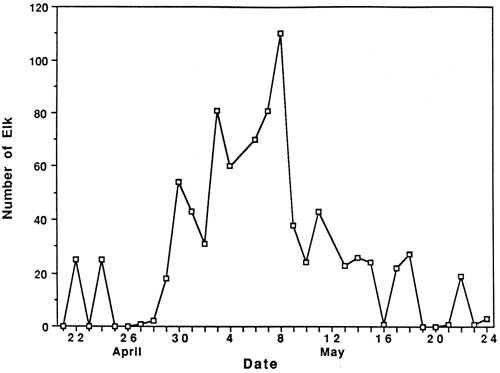
Fig. 1 Numbers of elk observed between 0530-0700 hrs. along an 8 mile road transect through open pasture in the Upper Klamath Basin, 22 April – 24 May 1985.
Reasons for the sudden decrease in elk observations following May 8th are unknown; however, it coincided with several important factors, including: (1) snow disappearance and greenup of adjacent forests and clearcuts, (2) increased rancher activities in pastures, (3) arrival of cattle in pastures, (4) increased wood cutting and recreational activities in surrounding areas, and (5) onset of calving. The rather abrupt arrival and dispersal of elk in the Upper Klamath Basin would place narrow seasonal constraints on any future elk monitoring activities in the Basin. Also, additional years of data would be necessary to assess year-to-year variability in elk numbers, and hence, the reliability of the trend index.
A total of 81 elk wee classified as calves or cows on summer ranges within CRLA during 1986, and 220 were classified on spring range adjacent to the park during 1985. Calf production as estimated from summer counts was 55 calves per 100 cows, not accounting for neonates that might have died prior to summer. Such productivity appeared to be greater than average estimates of 27 calves per 100 cows obtained in CRLA during the 1970’s (Hill 1976). Hill suggested that the earlier estimates may have been biased because many calves may not have been observed when only portions of herds were counted. This commonly occurs when calves form nursery groups on the perimeter of cow herds. If only groups that contained both cows and calves are counted, then production of calves during the 1970’s averaged 60 calves per 100 cows, which as Hill (1976) pointed out, is near the biotic potential of an elk herd. Although productivity of elk herds in CRLA appears to be high, calf ratios obtained during spring 1985 (25:100) were typical of those found throughout western Oregon (Harper 1985, Witmer 1980) and Washington (Jenkins 1981, Smith 1980). Sequential counts of calves and cows obtained during summer and the following spring have frequently been used as indices of calf survivorship. Unfortunately, overwinter survival of calves cannot be compiled from our data because counts were obtained during the spring prior to, rather than following, the summer classification counts. However, assuming no large differences existed in calf production between 1985 and 1986, comparisons of calf ratios from summer 1985 (55:100) and spring 1985 (25:100) suggest large reductions in the abundance of calves may occur over winter. Although several authors have observed low calf survivorship in Roosevelt elk (Witmer 1982, Merrill 1985), additional intensive surveys of calf ratios on summer ranges, and on spring ranges south of the park will be needed to better understand herd dynamics in CRLA. Such surveys will be very difficult because all elk in each herd must be classified, not just the easily observable portions of herds.
Seasonal Movements and Home Range
Radio-collared elk in the Crater Lake ecosystem migrated between winter ranges on the west slope of the Cascades, spring ranges on the east side, and summer ranges on the Cascade Crest. Spring migrations averaged 35 km between winter range on the Rogue River National Forest and spring range on the Winema National Forest. Late-spring migrations to summer range within Crater Lake National Park added approximately 16 km to the total migration distance between winter and summer ranges. Seasonal ranges of radio-collared elk are shown in Figs. 2-6, and are described in greater detail below.
Cow elk trapped during spring in the Upper Klamath Basin concentrated their activities along the eastern boundary of the Winema National Forest from Seven Mile Guard Station north to the park boundary. Elk arrived on spring range primarily between 20 April – 8 May during 1985, judging from the survey results (Fig. 1). During 1986, some radio-collared elk arrived on spring range as early as 1 April, and the majority had arrived by 21 April. Three late-comers did not arrive until sometime after 3 May. Telemetry data indicated that migration from winter to spring ranges was highly individualistic and occurred over at least a one-month period.
Movements of radio-collared elk were generally quite predictable on spring range. Most elk used clearcuts and private pastures along the USFS boundary for late night and early morning foraging bouts, and retreated westward to forested hillsides by day. Movements of two radio-collared cows deviated from the norm. One cow (designated cow #2) departed during early May 1985 and occupied a spring range partially separate from the others along Annie Creek and Sun Creek near the park’s panhandle (Fig. 2). Another cow, one of the early spring arrivals and the first elk trapped in 1985, traveled from Seven Mile Guard Station to a location 15 km west across the Cascade Crest, where she remained for 10 days before returning to spring range.
Radio-collared elk used the same spring ranges both years (Figs. 2-3). Annual differences in the distribution of elk in 1985 and 1986 were related to the trapping effort in 1985 and the resulting differences in sampling schedules. In 1985, we did not begin actively radio-tracking elk until most elk were captured in late May. In 1986, all except one elk were already radio-collared when they arrived on spring range, and they were radio-tracked beginning in early April. Distribution patterns of radio-collared elk in 1986 delineate the spring range of CRLA elk, whereas data from 1985 represent the late-season transition to summer range and the distribution of collared elk during calving season. Primary calving grounds of CRLA elk were in the remote headwaters of Seven Mile Creek, Dry Creek and the surrounding areas.
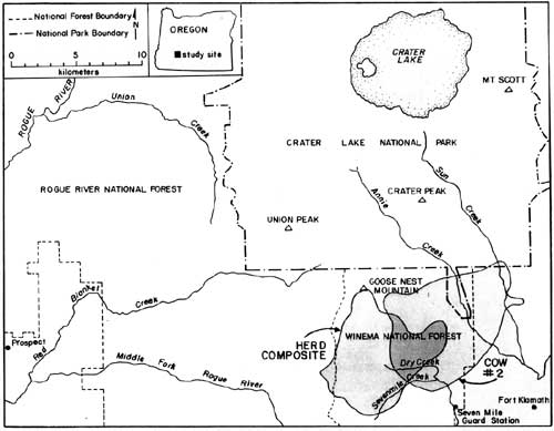
Fig. 2 – Elk home ranges, Spring 1985.
Migration of radio-collared elk from spring range to summer range consisted of gradual westerly and northerly upslope movements from the spring range. Migration to summer range had no discrete starting date, but distributions of elk began to shift in mid-May. Most elk were observed in the southern portion of their summer range near Goose Nest Mountain by 15 June 1985 and 1986.
Radio-collared elk returned to the same summer ranges both years (Fig. 4-5). The majority of radio-collared elk summered from the south slopes of Goose Nest Mountain throughout the west side of the park north to Highway 62. Composite home ranges of radio-equipped elk were approximately 60-75% within the park. Cow #2 inhabited a summer range in the Crater Peak area separate from the remaining collared elk. These two home range areas, in the southwest and southeast of the park, correspond to two previously identified concentration areas of elk in CRLA (Manning 1974, Hill 1974). None of our radio-collared elk inhabited the northern half of the park, although previous investigators and our observations indicated lesser numbers of elk also inhabit the northern half of the park, primarily in the northwest. In October 1985, a radio-collared bull elk from another study, collared in the Umpqua drainage, was located in the northwestern corner of the park. He remained there until early November, then he joined elk from the southwest corner of the park and migrated with them to winter range.
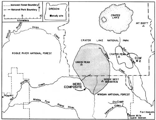
Fig. 4 – Elk home ranges, Summer 1985.
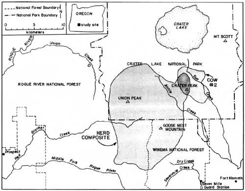
Fig. 5 – Elk home ranges, Summer 1986.
Migration of radio-collared elk from summer to winter range varied between 1985 and 1986. During 1985, 10 inches of snow fell in mid-September causing elk to move downslope toward spring range for three days. They returned to summer range as the snow melted. During the third week in October, snow accumulated to two feet on summer range, again forcing elk to their spring range near Seven Mile Guard Station, where they remained for two weeks. The elk crossed over the Cascade Crest to the upper basins of Red Blanket Canyon in early November, and moved slowly down Red Blanket Creek arriving on winter range in mid-November (Fig. 6). Cow #2, from the Crater Peak area, remained on spring range near Annie Creek for two weeks and then migrated through 4-5 feet of snow on the Cascade Crest down the Middle Fork of the Rogue River between 25-29 November.