
Stuart Falls Trail – Crater Lake National Park
| Difficulty: Moderate
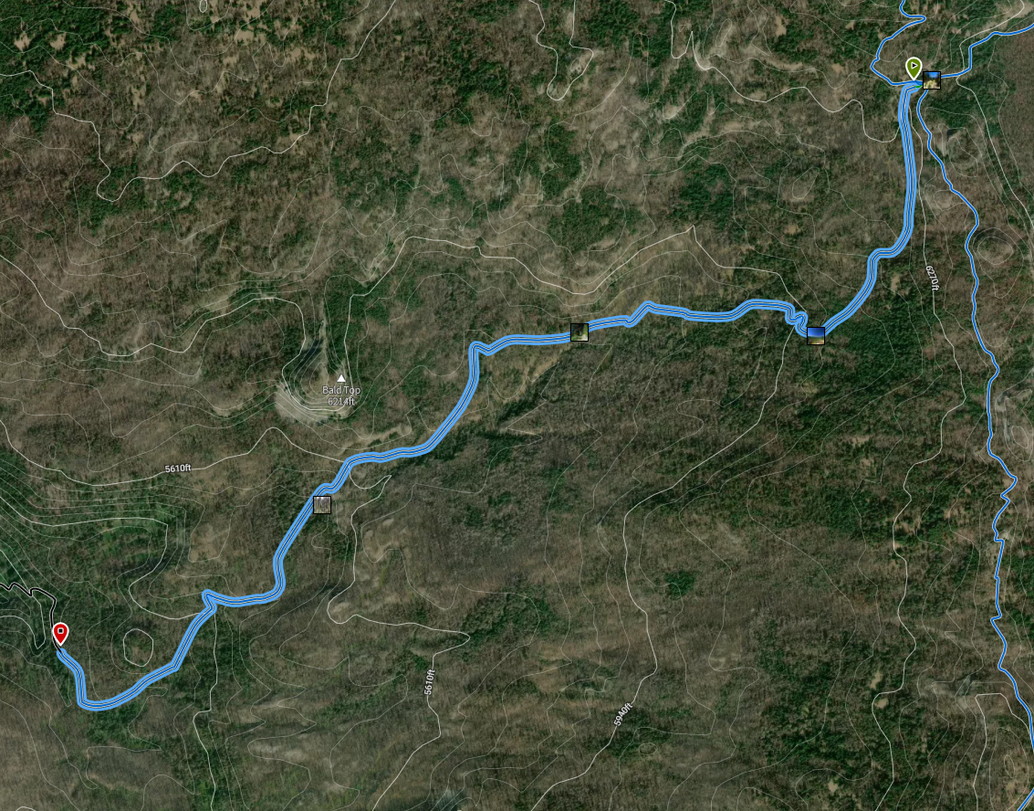
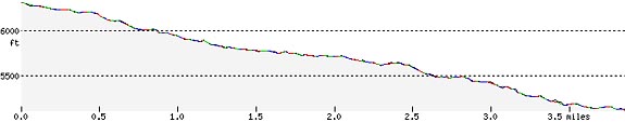
Length: 3.84 mi (6.2 km) Elevation: 5092* – 6299 ft (1552* – 1920 m) |
Trailhead coordinates:
Latitude: N +42° 48.96 or 42.81601 Longitude: W -122° 10.83 or -122.18052 Altitude: 6299 ft (1920 m) |
*intersection with Red Blanket Creek trails on Forest Service
REI Trails Project partners with Crater Lake Institute to produce their trails app. Click the map below, get the app – then come back, we offer more.
Trail Description
|
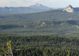
Union Peak is at the far right foreground and the Stuart Falls Trail lies behind it and in front of Mount McLoughlin, which is in the background and left of Union Peak, photo by Robert Mutch |

This section of trail connects the southern section of the Pacific Crest Trail with the Red Blanket Falls Trail on the adjoining Sky Lakes Wilderness. The northern half of this trail ends at the Crater Lake National Park southern border.
The forest overstory is a mixture of shasta red fir, mountain hemlock and lodgepole pine.
Trailhead location: Trailhead coordinates are given above for the location where the Stuart Falls Trail departs from the southern end of the Pacific Crest Trail. This trailhead can be reached from where Highway 62 meets with the PCT near the Annie Springs Entrance and south of the Annie Springs Entrance at a turnout.
Seasonal Information: Expect the trail to be covered in snow from October to early July, however, conditions vary somewhat from year to year. See Crater Lake Current Conditions for more information.
Stuart Falls Trail Elevation Profile
Related Maps
Digital USGS topographic maps (PDF files) – the following maps are relevant to the Stuart Falls trail. See more Crater Lake Institute online USGS digital maps.
| Series | Name | Year | Scale | Contour Interval | File |
| USGS 7.5′ | Union Peak | 1985 | 1:24,000 | 40 ft | usgs-union-peak-7.5 |
| USGS 30′ x 60′ | Crater Lake | 1989 | 1:100,000 | 50 m | usgs-crater-lake-30-minute |
| USGS 30′ x 60′ | Diamond Lake | 1978 | 1:100,000 | 50 m | usgs-diamond-lake-30-minute |
| USGS 1° x 2° | Klamath Falls | 1970 | 1:250,000 | 200 ft | usgs-klamath-falls-1-2 |
| USGS 1° x 2° | Medford | 1976 | 1:250,000 | 200 ft | usgs-medford-1-2 |
| USGS 1° x 2° | Roseburg | 1970 | 1:250,000 | 200 ft | usgs-roseburg-1-2 |
![]()
Please remember to practice “leave no trace outdoor ethics” when you are out on Crater Lake National Park’s trails…and have fun!
Other pages in this section
- Pacific Crest Trail
- Anderson Bluffs Trail
- Anne Creek Canyon Trail
- Anne Springs Cutoff Trail
- Bald Crater Loop Trail
- Bert Creek Trail
- Boundary Springs Trail
- Castle Crest Wildflower Trail
- Cleatwood Cove Trail
- Crater Peak Trail
- Discovery Point Trail
- Dutton Creek Trail
- Fumarole Bay Trail
- Garfield Peak Trail
- Godfrey Glenn Trail
- Lightning Spring Trail
- Llaos Hallway
- Mount Scott Trail
- Park Headquarters Historic Trail
- Pinnacles Valley Trail
- Plaikni Falls Trail
- Pumice Flat Trail
- Sun Notch Trail
- Union Peak Trail
- Watchman Peak Trail
- Wizard Island Summit Trail
- Hiking Rules and Regulations
- Best Trails at Crater Lake