
Crater Lake mapping boat gets a lift
Mail Tribune
Medford, Oregon
July 29, 2000
By PAUL FATTIG
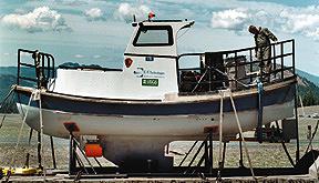
Bob Pennell photo
Army Reserve Sgt. Stephen Rhoads readies a Louisiana contractor’s boat, loaded with high-tech underwater mapping gear, for its trip into the caldera at Crater Lake National Park.
Scientists hit bottom
CRATER LAKE — Scientists using the latest deep-sea technology began mapping the bottom of the nation’s deepest lake late Friday afternoon.
A huge, olive-drab Chinook CH-47D helicopter with an Army reserve crew from Fort Lewis, Wash., transported the research vessel filled with sonar equipment from the rim of the lake onto the lake’s surface.
The 26-foot boat, dubbed the Surf Surveyor, had been dry-docked for a week on the rim while the National Park Service and U.S. Geological Survey scrambled to find a commercial helicopter capable of lifting the 11,200-pound craft into the lake. They turned to the military after a commercial aircraft could not be found.
“The biggest challenge so far has just been getting the boat into the lake,” said professor Larry Mayer, a marine geologist from the University of New Hampshire’s Center for Coastal and Ocean Mapping.
“The lake is very deep, so that will make it easier to map,” he said, noting that shallow bodies of water are more difficult to map because of the reduced swath of the sonar.
“Our plan is to start along the edge, then start criss-crossing the lake,” he said. “It should go real well.”
One of the two pilots was Phillip Raschke, chief warrant officer 3, a Seattle firefighter when he isn’t piloting a military helicopter.
“Lifting this is no problem for us,” he said of the boat. “The most difficult part will be getting the boat off the trailer without breaking anything.”
The Chinook, capable of lifting up to 26,000 pounds of cargo, didn’t break a thing as it gently lifted the craft and set it carefully in the lake.
The nearly $200,000 project is the first attempt to map the scenic lake since 1959. The focal point will be geothermal vents on the lake floor, which is 1,932 feet below the surface at its deepest point. The lake is the remnant of a 12,000-foot volcano that blew its top 7,700 years ago.
Researchers plan to post online computer images of color topographic maps of each day’s mapping. The newest maps of Crater Lake will be posted next week at http://tahoe.usgs.gov/craterlake/
The goal of the mapping is to learn more about the unusual lake, said Mac Brock, spokesman for Crater Lake National Park.
“It is a natural outdoor laboratory for world-renowned research,” he said. “Knowing more about the lake bottom helps scientists worldwide know more about volcanic lakes worldwide.”
In 1988, scientists in a tiny submarine surveyed about 2 percent of the lake floor. During that survey, they discovered hydrothermal vents with bacterial mats and tiny mites living around them.
Today’s researchers are armed with technology scientists back in 1959 had not dreamed of, said Jim Gardner, a marine geologist who is chief of Pacific seafloor mapping for USGS in Menlo Park, Calif.
“They mapped with acoustics like we’re doing, but they only had one beam that pointed straight down,” he said. “The problem is that beam spreads out. By the time it gets to 500 meters, it’s maybe 20 and 30 meters in diameter. And the shallowest spot in that big footprint is the one that gets recorded as the depth of the lake. It wasn’t very exact.”
The scientists are relying on high-resolution multibeam echo-sounder, which sends out pulses of sound two to three times a second, Gardner said. Those pulses break into 111 beams covering an arc of 160 degrees, he added.
In 1959, underwater mappers collected results from about 6,000 sound beams. When the current mapping is completed Thursday, about 50 million beams will be collected, Gardner said. Each will be accurate to within 50 centimeters, he said.
Owned by C&C Technologies Inc., of Lafayette, La., the craft contains about $3 million in sophisticated equipment, said Art Kleiner, a hydrographer who maps underwater features.
He and a co-worker will work in the boat for about 12 hours each day.
“We did Lake Tahoe two years ago, so we are somewhat familiar with high lakes,” Kleiner said. “Once the boat is in the water, we’ll just be doing our job as usual, only in beautiful scenery.”
Other pages in this section