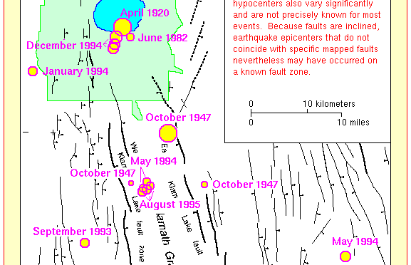

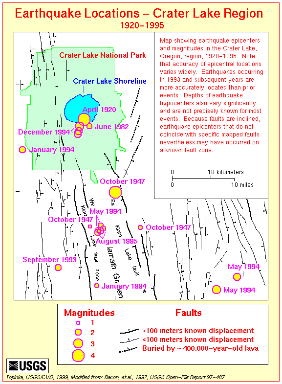
Map showing earthquake epicenters, and magnitudes in the Crater Lake, Oregon region, 1928-1995, Crater Lake, Oregon: Historical Earthquakes by Charles R. Bacon, Larry G. Mastin, Kevin M. Scott and Manuel Nathenson |
Prior to the 1993 Klamath Falls earthquakes, seismometers have been too few and too distant from Crater Lake to detect and accurately locate small earthquakes. There is, however, a sparse record of seismicity at Crater Lake and its vicinity.
The largest event took place in 1920 before there were many seismometers in Oregon. It is known to have been felt at Intensity V3, and had an estimated magnitude of 4+. The earthquake’s location is quite uncertain, though it is thought to have been near Crater Lake.
In 1947 there was an event with estimated magnitude of 3.7 south of Crater Lake near the town of Fort Klamath. One felt event in 1982 occurred near Crater Lake while a temporary array of seismic stations was deployed in Oregon …. [Crater Lake, Oregon: Historical Earthquakes by Charles R. Bacon, Larry G. Mastin, Kevin M. Scott and Manuel Nathenson].
Related Materials
- Volcano and Earthquake Hazards in the Crater Lake Region, Oregon by Charles R. Bacon, Larry G. Mastin, Kevin M. Scott and Manuel Nathenson
- Volcanic Evolution of the Crater Lake Region, Investigator’s Annual Report 12806, by Charles Bacon
Other pages in this section
*** previous title *** --- *** next title ***