

Stream, Running Water Erosion at Crater Lake National Park
|
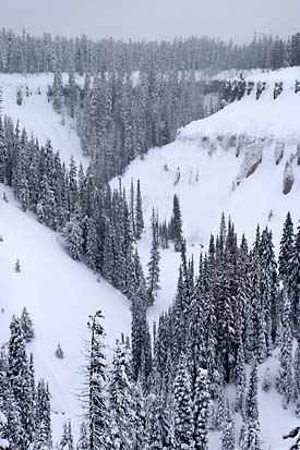
Winter photo of the deep stream-carved canyon of Annie Creek, Crater Lake National Park, Oregon, photo by Robert Mutch |
Water erosion is most often in the form of melting snow and groundwater flow (streams).
The original topography of Crater Lake National Park was buried under meters of pumice and other materials with the climactic eruption of Mount Mazama. These young deposits of pumice are strongly susceptible to water erosion which is most evident in the deeply eroded stream canyons around the park.
In addition to the erosive work of streams, the topography around Crater Lake’s caldera rim is also greatly affected by the work of water erosion. The inner caldera rim’s precipitous walls are made up of unconsolidated volcanic and glacial material and is subject to rockfalls and cavitation caused by wind and water erosion. Water erosion was one factor in its creation. Much of the water erosion within the rim is in the form of melting snow, but, there are also a few springs within the crater rim. [The Canyons of Crater Lake National Park, Warren D. Smith, Nature Notes From Crater Lake, 1935].
Articles and Books about Erosion
Nature Notes From Crater Lake
- The Pinnacles – D. S. Libbey, Vol. 4 No. 3 – September 1931
- Llao’s Hallway – Warren G. Moody, Vol. 6, No. 2 – 1933
- A Journey Into Llaos Hallway – Willis G. Downing, Vol. 22, 1956
- Repeat Photography and Landscape Change – Ron Mastrogiuseppe and John Salinas, Vol. 28, 1997 – repeat photography for erosional changes
- How Fast Is The Rim Retreating? – Earl W. Count, Vol. 6, No. 2 – 1933
- Fish and Stream Survey – O. L. Wallis, Vol. 13, 1947
- The Portals of Whitehorse Creek – Steve Mark, Vol. 30, 1999
Other pages in this section
*** previous title *** --- *** next title ***