
Geological History of Crater Lake
The first Geological Survey party visited the lake in 1883, when Everett Hayden and the writer, after spending several days in examining the rim, tumbled logs over the cliffs to the water’s edge, lashed them together with ropes to make a raft, and paddled over to the island. In 1886, under the direction of Capt. C. E. Dutton, many soundings of the lake were made by W. G. Steel, and a topographic map of the vicinity was prepared by Mark B. Kerr and Eugene Ricksecker. Dutton was the first to discover the more novel and salient features in the geological history of the lake, of which he has given for his entertaining pen an all too brief account.5
 |
|
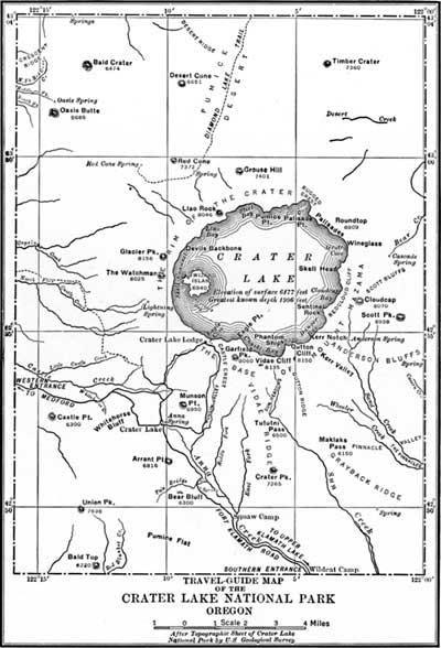
Figure 2. Map of Crater Lake National Park. |
Under the inspiration of the “Mazamas,” a society of mountain climbers in Portland, Oreg.,6 a more extended study of the lake was made by Government parties from the Department of Agriculture, the Fish Commission, and the Geological Survey.7
1 The Mountains of Oregon, by W. G. Steel, 1890, p. 13.
2 The discovery and early history of crater Lake, by M. W. Gorman, Mazama, Vol. I, No. 2, Crater Lake number, 1897, 159 pages. This number contains much valuable information concerning Crater Lake in addition to that referred to.
3 The names Watchman, Glacier, Llao, and Vidae, which appear on the map of the lake, have been adopted by the United States Board on Geographic Names.
4 Atlantis Arisen, by Mrs. Francis Fuller Victor. p. 179.
5 Science, Vol. VII, 1886, p. 179-182, and Eighth Annual Report of the United States Geological Survey, p. 156-159.
6 The National Geographic Magazine, Vol. VIII, 1897, page 58.
7 Crater Lake National Park, United States Geological Survey Professional Paper No. 3, 1902, 167 pages, 12 plates, by J. S. Diller, and H. B. Patton.