
The Geology and Petrography of Crater Lake National Park, 1902
PART I.
MOUNT MAZAMA.
GENERAL FEATURES.
The rim encircling Crater Lake, when seen from a distance from any side, appears as a broad cluster of gently sloping peaks rising about 1,000 feet above the general crest of the range on which they stand. A good view is obtained from the road along Anna Creek, where the southern portion of the rim appears as shown on Pl. III, B. Here Castle Crest and Vidae Peak are the most prominent features, with the canyon of Anna Creek in the foreground. The topographic prominence of Mount Mazama can be more fully realized when it is considered that it is close to the head of Rogue, Klamath, and Umpqua rivers. These are the only large streams breaking through the mountains to the sea between the Columbia and the Sacramento, and their watershed might be expected to be the principal peak of the Cascade Range.
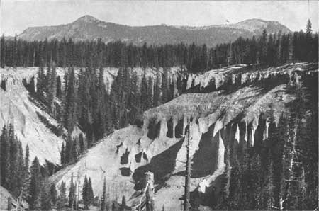
Plate III.—B. RIM OF CRATER LAKE ACROSS CANYON OF ANNA CREEK
In the foreground is the canyon of Anna Creek; in the background Castle Crest is seen on the left and Vidae Peak on the right.
To one arriving by the road at the crest of the rim, the lake in all its majestic beauty (Pl. IV) appears suddenly upon the scene, and is profoundly impressive. The eye beholds 20 miles of unbroken cliffs, the remnant of Mount Mazama, ranging from over 500 to nearly 2,000 feet in height, encircling a deep, blue sheet of placid water in which the mirrored walls vie with the original slopes in brilliancy and greatly enhance the depth of the prospect. The lake is about 4-1/4 miles wide and 6-1/4 miles long, with an area of nearly 20-1/2 square miles.
sorry, this plate was unavailable to show
Plate IV.—PANORAMIC VIEW OF CRATER LAKE.
(click on image for an enlargement in a new window)
From the wooded slope a short distance within the rim at Victor Rock, an excellent general view of the lake may be obtained. The first point to catch the eye is Wizard Island, lying nearly 2 miles away, near the western margin of the lake. Its irregular western edge and the steep but symmetrical truncated cone in the eastern portion are very suggestive of volcanic origin. We can not, however, indulge our first impulse to go at once to the island, for the various features of the rim are of greater importance in unraveling the earlier stages of its geological history.
On the left is the western border of the lake shown in Pl. IV, with the Watchman, Glacier Peak, and Devils Backbone opposite Wizard Island, and Llao Rock beyond. These features, with Victor Rock in the foreground instead of the Watchman, are much more clearly shown in Pl. V, from an excellent photograph by Mr. Cunningham. On the right is the southern border of the lake. Castle Crest, Kerr Notch, Scott Peak, Sentinel Rock, and Cloud Cap appear in the distance along the rim. The boldest part of the southern rim is cut off from this view by Castle Crest. A more complete general idea of Crater Lake and its surroundings may be obtained from the map, Pl. VI. The broad, gentle outer slope, with an inclination ranging from 10° to 15°, is in strong contrast with the abrupt inner slope, with its many cliffs. This difference is well expressed by the relative position of the contours in the map. The vertical interval of the contours is 100 feet. On the inner slope the contours are crowded close together to show an incline so steep that one needs to travel but a short way to descend 100 feet, while on the outer slope the contours are so far apart that one needs to travel a considerable portion of a mile to descend the same distance. The outer slope at all points is away from the lake; and as the rim rises at least a thousand feet above the general level of the crest of the range it is evidently the basal portion of a great hollow cone in which the lake is contained.
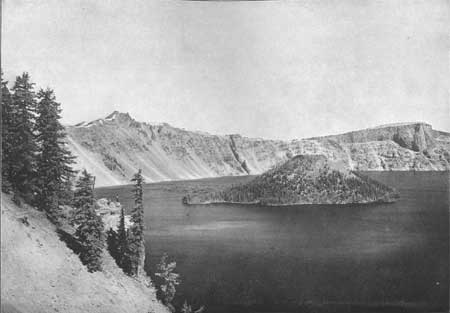
Plate V—WESTERN BORDER OF CRATER LAKE FROM VICTOR ROCK TO LLAO ROCK.
In addition to the strong contrast between the outer and inner slopes of the rim the map shows the occurrence of a number of small cones on the outer slope of the great cone. These adnate cones have peculiar significance when we come to consider the volcanic rocks of which the region is composed. The rim is ribbed by ridges and spurs radiating from the lake, and the head of each spur is marked by a prominence on the crest of the rim. The variation in the altitude of the rim crest is 1,460 feet, with seven points rising above 8,000 feet. The crest generally is passable, so that a pedestrian may follow it continuously around the lake, with the exception of short intervals on the southern side where the sharpest portion of the rim occurs in Castle Crest. At many points around the rim of the lake the best route is on the inner side, where the open slope, generally well marked with deer trails over beds of pumice, affords an unobstructed view of the majestic sheet of water.
The best way to get a comprehensive view of the base of Mount Mazama is to travel around the crest of the rim, but the structure is seen to greatest advantage from a boat on the lake.