
The Geology and Petrography of Crater Lake National Park, 1902
PART I.
MOUNT MAZAMA.
GLACIATION OF MOUNT MAZAMA.
The glaciers of Mount Mazama have left distinct records in the form of striae and moraines, with their outwash plains lower down upon the mountain slopes. The radial arrangement of the striae across the very crest of the rim overlooking the lake is clearly displayed, as shown on the map (Pl. VI). The rocks are well striated, especially upon the western and southern crest, and the glacial cutting has been sufficiently deep to remove all the surface features of the lava flows on the outer slope of the rim. On the adjacent slope toward the lake the same rocks present rough fracture surfaces showing no striae. The glaciation of the rim is a feature of the outer slope only, but it reaches the very crest. The glaciers that striated the crown of the rim carried stones in their lower parts, and must have come down from above. The central peak from which the glaciers radiated has disappeared, as it is evident that the topographic conditions of to-day afford no such source of supply.
The only portion of the rim along which positive signs of glaciation were not observed is opposite Scott Peak, and yet it is altogether probable that glaciers existed here, for near Sentinel Rock there appear to be two layers of gravel of glacial origin, and there are evidences of glaciation in the valley heading between Cloud Cap and Scott Peak and draining this portion of the crest. Below the cascade on the South Fork of Bear Creek the valley is bordered by one of the finest lateral moraines of the region. It is practically certain, therefore, that the crest of the rim has been glaciated throughout its entire circuit, excepting possibly Glacier Peak and the two highest points in the southern rim, and yet along these portions of the rim there is the clearest evidence of deep glacial cutting.
On the lower slope of Mount Mazama, the glaciers were broken up into tongues of glacial ice which occupied the valleys only, following closely the lines of drainage. One of the largest of these masses occupied the valley of Anna Creek, in the bottom of which glacial striae have been found at a distance of over 3 miles from the lake. Beyond this point all the lava flows in the middle portion of the valley are concealed by a thick coating of fine volcanic detritus washed down from the higher slopes of the volcano, filling the valleys to great depths and effectually obscuring the records made by the glacier at the time of its greatest extension.
The moraine of the Anna Creek glacier on the rim near Victor Rock has a thickness of over a hundred feet. It is composed of angular fragments up to 8 feet in diameter, commingled with sand and clay. Near by, on the outer slope, at the head of the main divide between Anna and Castle creeks, it is bowlder covered.
On descending from the crest to the springs at the head of Anna Creek, terraces may be seen bordering a sharp V-shaped canyon cut wholly in morainal material containing smoothed bowlders of andesite. Some of them are dark colored and inclose gray secretions. The U-shaped glacial valley of Anna Creek, a short distance below the crest, is 120 feet deep, with moraines on the sides and on an irregular bottom 50 yards in width. The canyon heads against cliffs over which several streams cascade, to disappear in the debris below. They are fed by the snow banks near the crest, in which the Anna Creek glacier has not made a decided notch, as have the glaciers of Sun and Sand creeks.
The moraine-filled valley of Anna Creek, 1-1/2 miles from the lake, has a width of nearly half a mile where meadows begin. The meadows become swampy in places, with fine pasture on somewhat irregular bottom, and continue to a morainal ridge 20 or 30 feet in height crossing the valley diagonally to the southwest, where the principal stream breaks through. At this terminal moraine the swampy patches cease and the valley becomes broad and dry. The stream near the west side, after passing the moraine, soon begins to cut into the somewhat irregular surface, where it becomes a well-marked plain covered with pumice and studded with pines and firs of moderate size. The stream cuts deeper and deeper into the plain as it advances, revealing a mass of fragmental material without definite stratification, although in places there are lines parallel to the surface of the pumice-covered plain. Three miles from the crest, and at least a mile beyond the small terminal moraine noted above, the stream exposes the rocky floor of the valley, which is clearly glaciated. The main stream at its junction with the west fork, which flows from the large spring near the wagon road, is a canyon 300 feet deep in comparatively fine volcanic material, like that of the plain above. The wagon road down the right bank of Anna Creek follows the plain for miles and affords fine views of the canyon. At the mouth of Pole Bridge Creek the plain is hummocky. It has not been leveled off and appears to be morainal, perhaps a portion of an earlier terminal moraine of the Anna Creek glacier, or of a side glacier along Pole Bridge Creek from Union Peak. This small valley is full of morainal material from the Union Peak region, which was also a glacial center, as is shown by the striae near the southwest corner of the park. The striae evidently record an ice movement from the Union Peak region north and northwest to join the Rogue River glacier from Mount Mazama. The distribution of the morainal material suggests another branch down Pole Bridge Creek to the Anna Creek glacier. The canyon of Anna Creek above the mouth of Pole Bridge Creek is shown in Pl. III, B. Below that point it has a depth of 300 to 400 feet, with almost inaccessible walls frequently ornamented by columns and other carved forms composed wholly of volcanic material. There are but few places where the stream can be reached. It is completely boxed in by cliffs, in which the jointed structure (Pl. XI) of the material is prominent.
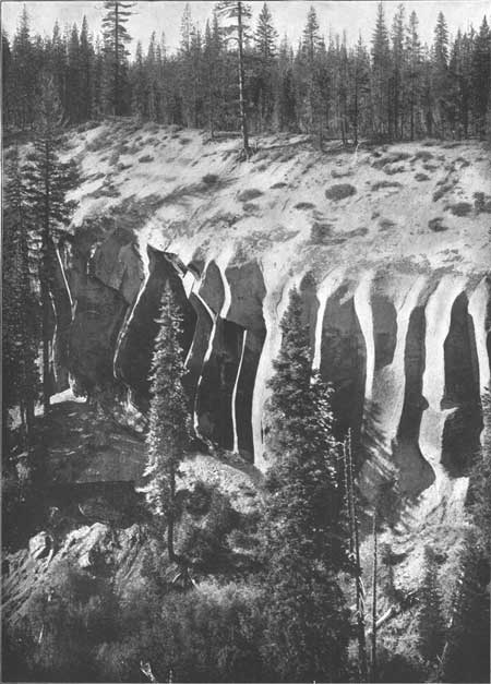
Plate XI.—JOINTED TUFF OF ANNA CREEK.
The ice at the mouth of Pole Bridge Creek may have been not less than a thousand feet thick, for it polished the rocks at an elevation of 6,500 feet on the summit immediately south of that stream. The terminal moraine of the Anna Creek glacier at the time of its greatest extension may have been buried by the deposits of the Wood River Valley or the Klamath lakes.
The glacial phenomena of Anna Creek illustrate quite fully those of all the other important streams heading in Mount Mazama and may be taken as a type. In general, the moraines of the upper slopes are succeeded by extensive plains of sand and pumice, which fill the valleys to great depths and give rise to the box canyons in which the streams leave the lower slopes of that great volcano.
Anna Creek carries a larger proportion of water from the rim of Crater Lake than any other stream, for the reason, most likely, that it receives much of its supply from the great snowdrifts caught within the southwest portion of the rim crest. East of it lie Sun and Sand creeks, both of which occupy well-marked glacial canyons. In strong contrast to these are the valleys of Castle Creek and other streams which drain the western slope of Mount Mazama into Rogue River without perceptibly notching that portion of the rim, unless we consider the gap between Glacial Peak and Llao Rock as such. The bowldery moraine surface on the Rogue River side of the rim is best displayed at the head of Castle Creek. Along the road to the lake and below it are great plains of sand and pumice stretching for many miles down Rogue River. Ground moraine is widespread, but no conspicuous terminal moraine was noted anywhere on the western slope. Possibly it has been covered up, or may have been inconspicuous and overlooked.
A large glacial stream filled the broad valley between Glacier Peak and Llao Rock and spread over the broad plain west of Red Cone to the western border of the park, where a remarkable series of meadows occurs, due, most likely, to glacial dams at their lower ends. The Rogue River glacier had a width, measured along the crest, of over 4 miles, and was probably by far the largest glacier of Mount Mazama.
The canyons of Sand and Sun creeks are among the most striking glacial phenomena of Mount Mazama. The notches they make in the rim are prominent features. The canyons are clearly of the glacial form. Their walls are glaciated and their floors strewn with morainal deposits, which on Sand Creek are succeeded below by the usual box canyon cut in the plain, underlain by thick deposits of volcanic material. The canyon is not so deep as that of Anna Creek, and the descent to the plain of Klamath Marsh, at the east foot of the mountain, is gradual. In the case of Sun Creek the conditions are somewhat different. For 2 miles from the crest the grade is gentle and the broad even floor is on glacial debris; then the creek descends abruptly, by falls hundreds of feet in height, to a relatively narrow canyon, which attains a depth of over a thousand feet, and continues to the plain of the Klamath lakes. The canyon walls are composed of dacite, terraced by successive flows much older than the gorge. The canyon, which is the great one opposite Crater Peak, has a floor of fine material three-fourths of a mile wide, in which the present stream has cut an inner canyon 200 feet in depth. This canyon may differ from that of Anna and Sand creeks in the amount of filling, but we have no full measure of their depth. On the other hand, it is possible that this deep rocky canyon records a condition not found elsewhere about Crater Lake.
The cutting of the canyons of Sun and Sand creeks was the final glacial work of Mount Mazama. They are the only ones coming down from the upper portion of the mountain and must represent its principal streams. They would, therefore, contain the glaciers which remained after the epoch of general glaciation, during which the broad divides between the canyons were ice covered.
The northeast slope of the rim was well glaciated by masses descending into the forks of Bear Creek, especially the South Fork, where the moraine field is large and covered with but little timber. A short distance northeast of the cascade on the South Fork there is a well-marked lateral moraine, the finest seen anywhere in the region. It is a smooth, even ridge 200 feet in height, containing many rounded pebbles and bowlders, often striated, and having a final thin coating of pumice. It was bordered by two glacial lobes in the lee of a spur heading between Cloud Cap and Scott Peak.