
Abstract
|
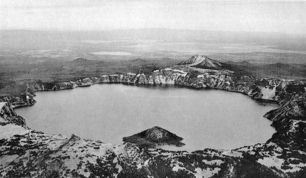
Photograph by 116th Photo Section, Washington National Guard Crater Lake viewed from the west Plate 1. The Watchman, one of the Northern Arc of Vents, rises on the caldera rim in front and to the left of Wizard Island. To the north (left) rises Hillman Peak, connected by a ridge with the parasitic cinder cone known as Forgotten Crater. Next to the left is the great dacite flow of Llao Rock. Continuing along the caldera rim, the white-topped cliff is Pumice Point, beyond which lies Cleetwood Cove, overlooked by the Cleetwood dacite flow. Farther on, where the caldera wall is low, are the thick andesite flows of the Palisades and Roundtop, which rest on glacial deposits. The conspicuous V-shaped cliff on the distant wall is formed by the Redcloud dacite flow; beyond it rises Mount Scott. The numerous hills on the outer slopes of Mount Mazama, behind Mount Scott, are parasitic dome of andesite and dacite. Still farther away is the interior plateau, thickly covered a with the deposits of pumice flows (nuées ardentes). |
IN LATE Cretaceous times, the site of the Oregon Cascades was largely if not entirely occupied by a shallow sea. During the Eocene period, widespread uplift drove the coast westward beyond the line of the Cascade Range, never to return. Volcanism began in eastern Washington during the early Eocene and gradually spread southward over Oregon. By late Eocene times, volcanoes were active throughout the present Cascade belt and on the plateau of central Oregon. The climate of Oregon was then warm temperate or subtropical, and a low plain spread far inland. During Oligocene and Miocene times, volcanism continued on a grand scale. Farther east, the volcanic deposits of the John Day formation had been laid down over an extensive area and had been buried during the Middle Miocene by enormous outpourings of Columbia River plateau basalt, erupted from swarms of fissures. Meanwhile the climate had become cooler and a temperate, redwood flora had replaced the warmer floras of the Eocene. Still, however, no high mountain range divided eastern from western Oregon.
At the end of the Miocene period, renewed earth movements took place. At the same time, the volcanics of the Western Cascades were intruded by an approximately north-south line of dioritic stocks. Simultaneously, north-south fractures opened along and near what is now the crest of the Cascade Range. An important effect of these disturbances was the elevation of a mountain barrier which shut off eastern Oregon from the supply of moisture-laden winds. For the first time, the floras on opposite sides of the Cascades began to show the marked differences which they exhibit today.
During the Pliocene period, the disturbed rocks or the Western Cascades suffered rapid erosion, and along the summit of the range they were buried by the products of High Cascade volcanoes. These volcanoes were less explosive than those which had formed the Western Cascade series, and their products were less diverse. Whereas the older lavas range from rhyolite to basalt, those of the High Cascade cones are almost entirely composed of olivine-bearing basaltic andesite and basalt. Many a£ these younger flows poured for long distances down canyons cut across the Western Cascades.
By the close of the Pliocene period, the crest of the Cascade Range had become a high plateau surmounted by overlapping shield-shaped cones of basic lava. In the succeeding Pleistocene period, a narrower, north-south belt of giant andesitic volcanoes commenced to form on the basaltic plateau. These continued to erupt and grow until Recent times. Today they form the crowning peaks of the Cascade Range. The bulk of this report deals with the rise of one of these andesitic cones, Mount Mazama, and the manner in which its summit was destroyed.
Mount Mazama rose from a basement the elevation of which lay between 5000 and 6000 feet. By the time the volcano reached full stature, the summit rose to a height of approximately 12,000 feet. The main cone was built chiefly by quiet effusions of hypersthene andesite. Explosive activity was relatively unimportant. Eruptions took place from a number of conduits, the positions of which changed from time to time. Accordingly, Mount Mazama was never a simple, symmetrical cone; it was, rather, a complex of overlapping cones.