
Classification of the Soils
Castlecrest Series
Depth class: Very deep
Drainage class: Somewhat excessively drained
Permeability: Rapid
Position on landscape: Mountain flanks and mountainsides
Parent material: Pumice and ash
Slope range: 0 to 80 percent
Elevation: 5,000 to 8,000 feet
Average annual precipitation: 40 to 70 inches
Average annual air temperature: 38 to 42 degrees F
Frost-free period: 0 to 50 days
Taxonomic class: Ashy, amorphic Typic Vitricryands
Typical Pedon
Oi—0 to 1 inch; slightly decomposed needle litter; abrupt wavy boundary.
A—1 inch to 3 inches; very dark grayish brown (10YR 3/2) paragravelly ashy loamy sand, dark grayish brown (10YR 4/2) dry; single grain; loose, nonsticky and nonplastic; common fine and medium roots; many fine interstitial pores; 15 percent pumice paragravel; slightly acid (pH 6.2); clear smooth boundary.
Bw—3 to 19 inches; brown (10YR 4/3) paragravelly ashy loamy sand, brown (10YR 5/3) dry; single grain; loose, nonsticky and nonplastic; common fine and medium roots; many fine interstitial pores; 15 percent pumice paragravel; slightly acid (pH 6.2); clear smooth boundary.
C1—19 to 26 inches; very dark grayish brown and dark grayish brown (10YR 3/2 and 10YR 4/2) ashy sand, brown (10YR 4/3 and 10YR 5/3) dry; single grain; loose, nonsticky and nonplastic; many fine interstitial pores; 7 percent pumice paragravel; slightly acid (pH 6.4); clear wavy boundary.
C2—26 to 38 inches; gray and very dark gray (10YR 6/1 and 10YR 3/1) ashy coarse sand, light gray and dark grayish brown (10YR 7/2 and 10YR 4/2) dry; single grain; loose, nonsticky and nonplastic; many fine interstitial pores; 5 percent pumice paragravel; slightly acid (pH 6.4); gradual wavy boundary.
C3—38 to 64 inches; light yellowish brown and very dark gray (10YR 6/4 and 10YR 3/1) ashy coarse sand, very pale brown and dark grayish brown (10YR 7/4 and 10YR 4/2) dry; single grain; loose, nonsticky and nonplastic; many fine interstitial pores; 5 percent pumice paragravel; slightly acid (pH 6.4).
Typical Pedon Location
Map unit in which located: Unionpeak-Castlecrest-Sunnotch complex, 0 to 15 percent slopes
Location in park: About 2.3 miles east-northeast of the Pumice Desert viewpoint; 568327 meters easting and 4765143 meters northing,
UTM Zone 10T, NAD 27; lat. 43o2’15.65″ N., long. 122o9’44.53″ W.
Range in Characteristics
Profile:
Depth to bedrock—more than 60 inches
Thickness of solum—14 to 30 inches
Average content of rock fragments and pararock fragments—less than 35 percent
Hue—7.5YR or 10YR
An albic (E) horizon as much as 3 inches thick is in some pedons (fig. 8).
A horizon:
Value—2 to 5 moist, 3 to 6 dry
Chroma—2 to 4 moist or dry
Texture—ashy sandy loam, ashy loamy sand, gravelly ashy sandy loam, gravelly ashy loamy sand, and paragravelly ashy loamy sand
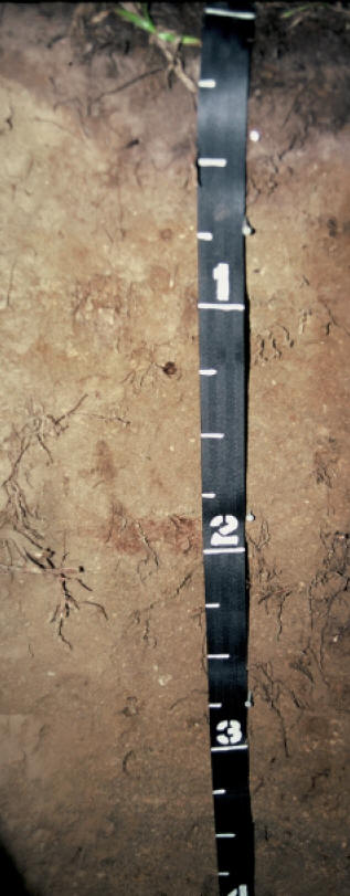
Figure 8.—Typical profile of a Castlecrest soil. Note the white, discontinuous E horizon at a depth of about 4 inches. Measurements on tape are in feet.
Content of pumice paragravel—0 to 15 percent
Content of cinder gravel—0 to 8 percent
Content of andesite gravel—0 to 15 percent
Content of andesite cobbles—0 to 3 percent
Bw horizon:
Value—3 or 4 moist, 4 to 6 dry
Chroma—2 to 4 moist or dry
Texture—ashy loamy sand, ashy sandy loam, or ashy sand
Content of pumice paragravel—0 to 15 percent
Content of cinder gravel—0 to 5 percent
Content of andesite gravel—0 to 20 percent
Content of andesite cobbles—0 to 3 percent
C horizon:
Value—3 to 6 moist, 4 to 7 dry
Chroma—1 to 6 moist, 2 to 6 dry
Texture—ashy sand, ashy coarse sand, or ashy loamy sand
Content of pumice paragravel (upper part)—0 to 15 percent
Content of pumice paragravel (lower part)—0 to 60 percent
Content of cinder gravel—0 to 20 percent
Content of andesite gravel—0 to 15 percent
Content of andesite or cinder cobbles—0 to 2 percent
***previous*** — ***next***