
Classification of the Soils
Collier Series
Depth class: Very deep (fig. 9)
Drainage class: Somewhat excessively drained
Permeability: Rapid
Position on landscape: Ashflows
Parent material: Ash and cinders
Slope range: 0 to 80 percent
Elevation: 4,000 to 6,000 feet
Average annual precipitation: 20 to 60 inches
Average annual air temperature: 41 to 44 degrees F
Frost-free period: 0 to 50 days
Taxonomic class: Ashy, glassy Xeric Vitricryands
Typical Pedon
Oi—0 to 1 inch; slightly decomposed needle litter.
A—1 inch to 5 inches; very dark brown (10YR 2/2) ashy sandy loam, dark yellowish brown (10YR 4/4) dry; weak fine granular structure; loose, very friable, nonsticky and nonplastic; many very fine and fine roots and common medium roots; many very fine interstitial pores; 5 percent pumice paragravel and 3 percent hard gravel; slightly acid (pH 6.1); clear wavy boundary.
BA—5 to 12 inches; dark brown (7.5YR 3/2) ashy loamy sand, brown (7.5YR 5/2) dry; weak fine subangular blocky structure; loose, nonsticky and nonplastic; many very fine and fine roots; many fine interstitial pores; 5 percent pumice paragravel and 3 percent hard gravel; slightly acid (pH 6.1); clear wavy boundary.
Bw—12 to 23 inches; brown (7.5YR 4/2) paragravelly ashy loamy sand, light brown (7.5YR 6/3) dry; weak fine subangular blocky structure; loose, nonsticky and nonplastic; few very fine roots; many fine interstitial pores; 15 percent pumice paragravel and 8 percent hard gravel; slightly acid (pH 6.1); clear wavy boundary.
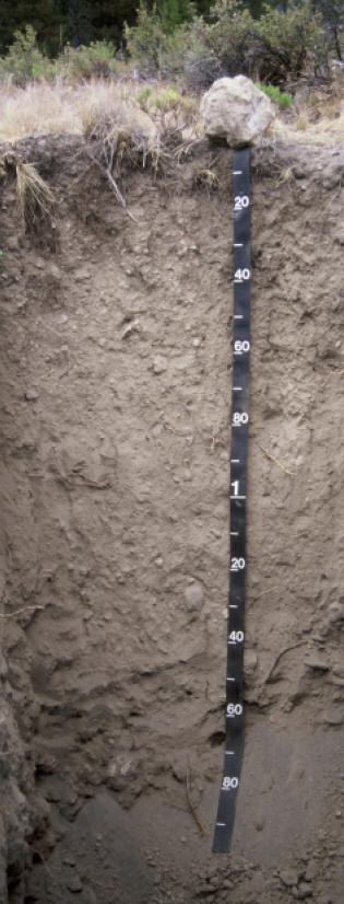
Figure 9.—Typical profile of a Collier soil. Measurements on tape are in centimeters.
C—23 to 62 inches; brown (7.5YR 4/4) paragravelly ashy sand, light brown (7.5YR 6/4) dry; single grain; slightly hard, very friable, nonsticky and nonplastic; few fine roots; many fine interstitial pores; 15 percent pumice paragravel and 8 percent cinder gravel; neutral (pH 6.6).
Typical Pedon Location
Map unit in which located: Collier ashy loamy sand, 0 to 7 percent slopes
Location in park: About 2 miles west of Sharps Peak; 579858 meters easting and 4760342 meters northing, UTM Zone 10T, NAD 27; lat. 42o59’36.00″ N., long. 122o01’17.48″ W.
Range in Characteristics
Profile:
Depth to bedrock—more than 60 inches
Thickness of solum—14 to 30 inches
Average content of rock fragments—less than 35 percent
Hue—5YR, 7.5YR, or 10YR
A horizon:
Value—2 or 3 moist, 3 to 5 dry
Chroma—2 or 3 moist or dry
Texture—ashy sandy loam, ashy loamy sand, and very gravelly ashy loamy sand
Content of cinder gravel—0 to 15 percent
Content of pumice paragravel—0 to 15 percent
Content of andesite gravel—0 to 15 percent
Content of clay—0 to 3 percent
Bw horizon:
Value—3 or 4 moist, 4 or 5 dry
Chroma—3 or 4 moist or dry
Texture—ashy loamy sand or ashy sandy loam
Content of cinder gravel—0 to 15 percent
Content of pumice paragravel—0 to 20 percent
Content of andesite gravel—0 to 10 percent
Content of clay—0 to 5 percent
C horizon:
Value—3 or 4 moist, 4 or 5 dry
Chroma—2 to 4 moist or dry
Texture—ashy loamy sand or ashy sand
Content of cinder gravel—0 to 20 percent
Content of pumice paragravel—0 to 25 percent
Content of andesite gravel—0 to 10 percent
Content of cinder cobbles—0 to 5 percent
Content of cinder stones—0 to 5 percent
Content of clay—0 to 2 percent
***previous*** — ***next***