
Classification of the Soils
Maklak Series
Depth class: Very deep
Drainage class: Excessively drained
Permeability: Very rapid
Position on landscape: Pumice flows
Parent material: Pumice and ash (fig. 12)
Slope range: 0 to 10 percent
Elevation: 4,500 to 6,000 feet
Average annual precipitation: 30 to 60 inches
Average annual precipitation: 38 to 42 degrees F
Frost-free period: 10 to 50 days
Taxonomic class: Ashy-pumiceous, glassy Xeric Vitricryands
Typical Pedon
Oi—0 to 1 inch; black (10YR 2/1) slightly decomposed needle litter; abrupt smooth boundary.
A—1 inch to 4 inches; very dark grayish brown (10YR 3/2) paragravelly ashy loamy sand, brown consisting of decomposing roots on surface of boulders; neutral (pH 6.6).
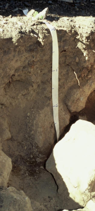
Figure 11.—Typical profile of a Llaorock soil. Measurements on tape are in feet.
Typical Pedon Location
Map unit in which located: Llaorock-Castlecrest complex, 0 to 15 percent slopes (10YR 5/3) dry; weak fine subangular blocky structure; loose, nonsticky and nonplastic; common very fine and fine roots and few medium roots; many very fine interstitial pores; 30 percent fine pumice paragravel; moderately acid (pH 6.0); clear smooth boundary.
Bw—4 to 15 inches; dark brown (10YR 3/3) very paragravelly ashy loamy sand, brown (10YR 5/3) dry; single grain; loose, nonsticky and nonplastic; many very fine, fine, and medium roots and common coarse roots; many fine interstitial pores; 30 percent fine pumice paragravel and 25 percent pumice paracobbles; moderately acid (pH 6.0); clear wavy boundary.
C1—15 to 25 inches; brown (10YR 4/3) extremely paracobbly ashy loamy sand, pale brown (10YR 6/3) dry; single grain; loose, nonsticky and nonplastic; common medium and few fine roots; many fine interstitial pores; 30 percent pumice paragravel and 40 percent pumice paracobbles; slightly acid (pH 6.2); clear smooth boundary.
C2—25 to 60 inches; dark reddish brown (5YR 3/4) extremely paragravelly ashy loamy sand, reddish brown (5YR 5/4) dry; single grain; loose, nonsticky and nonplastic; common fine and medium roots; many fine interstitial pores; 70 percent pinkish gray (5YR 7/2) pumice paragravel and 15 percent pinkish gray (5YR 7/2) pumice paracobbles; moderately acid (pH 6.0).
Typical Pedon Location
Map unit in which located: Maklak paragravelly ashy loamy sand, 0 to 10 percent slopes
Location in park: About 1/2 mile west and 1/2 mile south of the northeastern corner; 580676 meters easting and 4770013 meters northing, UTM Zone 10T, NAD 27
Range in Characteristics
Profile:
Depth to bedrock—more than 60 inches
Thickness of solum—14 to 35 inches
Hue—10YR, 7.5YR, or 5YR
Content of clay—0 to 7 percent
A horizon:
Value—2 or 3 moist, 4 or 5 dry
Chroma—2 or 3 moist or dry
Content of pumice paragravel—15 to 30 percent
Content of pumice paracobbles—0 to 10 percent
Bw horizon:
Value—3 to 5 moist, 5 to 7 dry
Chroma—2 to 6 moist or dry
Texture—ashy loamy sand or ashy loamy coarse sand
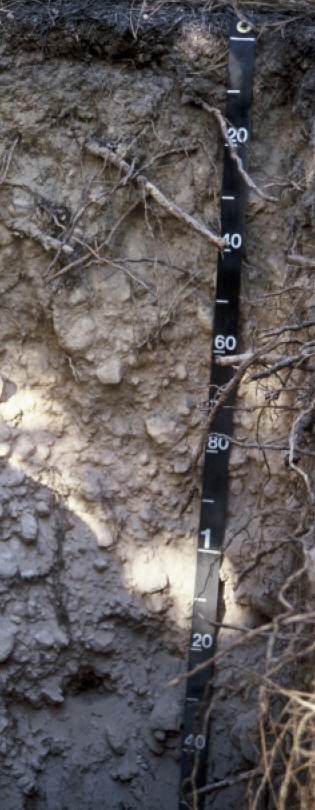
Figure 12.—Typical profile of a Maklak soil. Fragments are paracobble-sized pumice. Measurements on tape are in centimeters.
Average content of pumice paragravel—25 to 50 percent
Content of pumice paracobbles—15 to 25 percent
C horizon:
Value—3 to 7 moist, 5 to 8 dry
Chroma—2 to 6 moist or dry
Texture—ashy loamy sand or ashy loamy coarse sand
Average content of pumice paragravel—25 to 70 percent
Average content of pumice paracobbles—15 to 45 percent
***previous*** — ***next***