
Crater Lake National Park: Presently Tranquil
Selected Issues in The USGS Marine and Coastal Geology Program
United States Department of the Interior – U.S. Geological Survey 1995
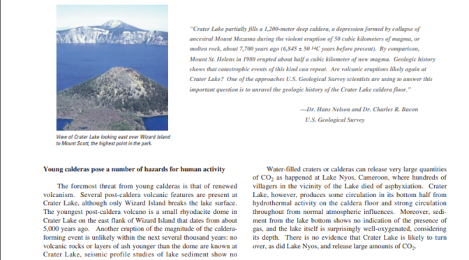
View entire report (PDF) presently-tranquil-crater-lake View of Crater Lake looking east over Wizard Island to Mount Scott, the highest point in the park.
“Crater Lake partially fills a 1,200-meter deep caldera, a depression formed by collapse of ancestral Mount Mazama during the violent eruption of 50 cubic kilometers of magma, or molten rock, about 7,700 years ago (6,845 +/- 50 14C years before present). By comparison, Mount St. Helens in 1980 erupted about half a cubic kilometer of new magma. Geologic history shows that catastrophic events of this kind can repeat. Are volcanic eruptions likely again at Crater Lake? One of the approaches U.S. Geological Survey scientists are using to answer this important question is to unravel the geologic history of the Crater Lake caldera floor.”
– Dr. Hans Nelson and Dr. Charles R. Bacon, U.S. Geological Survey
Young calderas pose a number of hazards for human activity
The foremost threat from young calderas is that of renewed volcanism. Several post-caldera volcanic features are present at Crater Lake, although only Wizard Island breaks the lake surface. The youngest post-caldera volcano is a small rhyodacite dome in Crater Lake on the east flank of Wizard Island that dates from about 5,000 years ago. Another eruption of the magnitude of the caldera-forming event is unlikely within the next several thousand years: no volcanic rocks or layers of ash younger than the dome are known at Crater Lake, seismic profile studies of lake sediment show no evidence of subsurface magma movement, and there have been no earthquakes of the kind associated with volcanism. However, there is every reason to expect future activity in the place where it has been occurring for at least 400,000 years. Should there be an eruption within the caldera, it would likely happen underwater, increasing the possibility of enhanced explosive power due to the interaction of magma and hot rock with water.
Calderas filled with water can produce tremendous flooding in the immediate vicinity if the caldera wall fails, as happened to Aniakchak Crater in Alaska when its rim was breached. Crater Lake shows no signs of imminent crater-wall failure: the last major wall failure occurred over 7,500 years ago, after the formation of the subaerial central platform of post-caldera lava flows, but before the lake water began accumulating. The Chaski slide, one block of which forms a prominent bench east of Crater Lake Lodge, was the last major landslide event and carried debris to the center of the caldera floor.
Water-filled craters or calderas can release very large quantities of CO2 as happened at Lake Nyos, Cameroon, where hundreds of villagers in the vicinity of the Lake died of asphyxiation. Crater Lake, however, produces some circulation in its bottom half from hydrothermal activity on the caldera floor and strong circulation throughout from normal atmospheric influences. Moreover, sediment from the lake bottom shows no indication of the presence of gas, and the lake itself is surprisingly well-oxygenated, considering its depth. There is no evidence that Crater Lake is likely to turn over, as did Lake Nyos, and release large amounts of CO2.
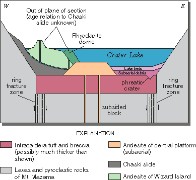 |
| Schematic geologic cross section across the caldera floor of Crater Lake showing relationship and sequence of formation of post-caldera volcanic features, subaerial debris layers, and lake sediment beds. Not drawn to scale or as an exact cross section line. |
Understanding the history and evolution of calderas may help scientists predict when and where disasters are likely to occur
The interdisciplinary study of the Crater Lake caldera floor required extensive logistical assistance from the National Park Service and collaboration with scientists from Oregon State University in use of underwater vehicles. U.S. Geological Survey (USGS) scientists determined the geologic history of Crater Lake itself through detailed studies of the caldera and the Pacific ocean floor. The climactic eruption of Mount Mazama resulted in deposition of pumice and ash over more than a million square kilometers of the Pacific Northwest. Soon after, ash deposited in the Columbia River drainage basin was transported westward from the Pacific coast up to 700 kilometers offshore on the northeast Pacific ocean floor by turbidity currents along deep-sea channels. Collapse of the former volcanic edifice along a ring fracture system, forming the caldera, occurred during the eruption and compensated for the ejection of the 50 cubic kilometers of magma. Part of the erupted material fell within the developing caldera to form a plug of intracaldera tuff that may be as much as 2 kilometers thick. The basin that now contains Crater Lake is the resulting collapse caldera, 1,200 meters deep and 8 to10 kilometers in diameter at the rim. In a matter of only a few hundred years, the caldera was partially filled, first with landslide debris from the walls and later with post-caldera volcanic rocks, water, and lake sediment.