
Hydrology of Crater, East and Davis Lakes, Oregon by Kenneth N. Phillips
CRATER LAKE
WATER LOSS FROM THE LAKE
SEEPAGE LOSS
SEEPAGE RATE IN RELATION TO LAKE LEVEL
It is desirable to know whether the leakage of 89 cfs computed for periods in 1961-62 is virtually constant, as would be expected if the leaks were at great depth, or whether it increases materially at higher stages, as would be expected if some of the leaks were at or near the water surface.
By utilizing the hydrologic data available, and assuming (1) the validity of the relationship of precipitation and inflow previously determined, and (2) the 23-inch annual evaporation loss (p. E20) as unvarying from year to year, seepage-loss rates ranging from 86 to 100 cfs have been calculated for low, medium, and high lake levels in seven periods of 1 to 8 years each (table 5). The calculated seepage rates have been compared graphically (fig. 5) with average lake levels in those periods.
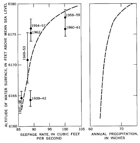 |
| FIGURE 5.-Relation between the average stage of Crater Lake and (1) the computed seepage rates for water years shown (range of stage indicated by vertical bars) and (2) the computed annual precipitation required at the weather station to maintain a constant stage. |
Figure 5 shows that the seepage rate ranges only from about 86 cfs to 101 cfs for the observed range in lake level, 6,163 to 6,179 feet. The computed points are somewhat erratic in position, and a straight-line curve possibly may better express the true relationship between stage and seepage rate. However, the curve in figure 5 is based in part on evidence that the lake has never been above 6,180.5 feet. The seepage rate probably increases rather sharply as the water level rises from 6,175 to 6,180 feet and serves as a regulator to keep the lake at levels little if any higher than those reached in recent years. This tentative conclusion is given weight by the botanical evidence (p. E13) that (1) the lake has certainly not been higher than the root system of the dead pine at 6,182.9 feet for at least 430 years, and (2) that it has probably never been higher than 6,180.5 feet. The steepness of any possible curve indicates that seepage varies little within the usual range, 6,165 to 6,175 feet, and suggests that most of the seepage occurs at some depth below the usual lake surface.
Although the increase in seepage at levels above 6,175 feet, as shown in figure 5, may be an effective control against Crater Lake ever reaching a level higher than about 6,181 feet, a recession to a level lower than any in the record could occur as a result of a long period of deficient precipitation.
Figure 5 also shows the computed annual precipitation at Crater Lake Weather Station needed to maintain the lake at various levels, assuming an annual evaporation loss of 23 inches (p. E20). For example, a uniform annual precipitation of 65 inches should cause the lake to rise or fall to 6,172 feet, at which altitude the computed losses by evaporation and seepage would balance the supply.
| Table 5. – Computed seepage rates from Crater Lake 1 |
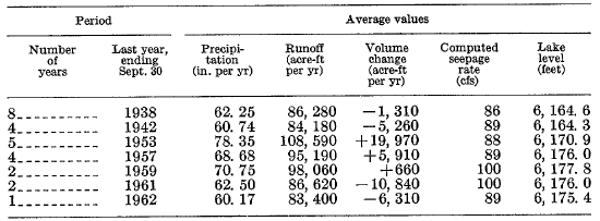 |
1 Precipitation is that observed at Crater Lake Weather Station. Runoff includes precipitation and is computed as 1,386 acre-feet per inch of precipitation. Volume change is computed from observed change in stage and constant lake area of 13,140 acres. Annual evaporation toss is assumed constant as 23 inches (25,180 acre-It) per year. Lake level is partly estimated because of lack of data in winter and spring periods.
***previous*** — ***next***