
Hydrology of Crater, East and Davis Lakes, Oregon by Kenneth N. Phillips
INTRODUCTION
ACKNOWLEDGMENTS
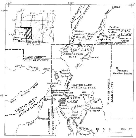
Several organizations have provided valuable information and assistance during the present study. Most of the water-level data on Crater Lake were provided by the U.S. National Park Service. The bathymetric chart for Crater Lake (fig. 3) is from a lake-bottom survey made by the U.S. Coast and Geodetic Survey. The area-volume curve and some water-level data for Davis Lake are from an unpublished engineering report by the U.S. Reclamation Service. The office of the Oregon State Engineer furnished data on Davis Lake levels and cooperated with the U.S. Geological Survey in operating stream-gaging stations to obtain data essential to this study; watermasters of that office, Aubrey Perry and James Fellows of Bend, deserve special thanks for assistance in the field.
Many individuals also were helpful in the study. The writers are especially grateful to Mr. B. W. Black, formerly chief park naturalist at Crater Lake, for assistance in the field and for criticism of a draft of the section on hydrology of Crater Lake, to Mr. S. T. Harding, consulting engineer, for results of his field observations and unpublished notes on the hydrology of Crater and Davis Lakes, to Dr. D. B. Lawrence for results of his observations on tree rings and water levels at Crater, Davis, and East Lakes, and to Mr. C. H. Nelson for the use of an unpublished thesis on the limnology of Crater Lake.
Within the Geological Survey, George T. Hirashima checked most of the hydrologic computations, and many other members of the staff contributed valuable suggestions. Walter B. Langbein and S. E. Rantz were principal reviewers of the final manuscript. Special gratitude is extended to Nyra Johnson for her dedication, patience, and understanding during the typing and assembly of this manuscript.
 |
| FIGURE 3.-Bathymetric chart of Crater Lake. |
***previous*** — ***next***