
Hydrology of Crater, East and Davis Lakes, Oregon by Kenneth N. Phillips
CRATER LAKE
RECORDS OF LAKE LEVEL
Records of lake level are given in table 7 and are summarized in figure 4. All data are referred to a common datum by which the bench mark at the southwest shore of the lake is 6,178.955 feet above mean sea level (Marshall, 1914, p. 88). Some readings are subject to error because of waves or because of the need to use temporary reference marks, but the record, although fragmentary, is in general dependable. The highest level in many years was 6,179.06 feet in June 1958 (by later measurement to high-water mark); a slightly higher level may have occurred in 1904. The lowest level known is 6,163.2 feet, September 10,1942.
Prior to September 1961, the occasional observations of lake level were made at several different gages at the southwest shore. On September 14, 1961, a water-stage recorder was installed at Cleetwood Cove on the northeast shore. The continuous trace of that recorder in 1961-62 was used to determine (1) the rate of seepage loss from the lake in cold periods of no precipitation and little evaporation and inflow, and (2) the increment to the lake in periods of heavy precipitation, for comparison with precipitation at the weather station. (It was necessary to ascertain the seepage rate first, because that loss continues during periods of precipitation.)
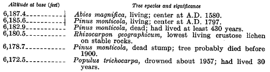
A change in the pattern of lichen growth at altitude 6,180.5 feet has been noted by many observers since 1915. The lowest living crustose lichens reach that level on the rock walls around the lake, and that level is thought to represent the highest stage ever reached by Crater Lake; the date of that high level is not known. Moreover, large living conifers along the shores of Crater Lake have their root systems within a few feet of historic high-water levels. Nelson (1961, p.’28-32) refers to the following observations made in August 1960 by D. B. Lawrence, who took cores from several of those trees and counted their annual growth rings to ascertain their age.
| Altitude at base (feet) Tree species and significance |
 |
Certainly the level of the lake has not been higher than the root system of living conifer trees within their lifetimes. From the botanical evidence, the relative youthfulness of the caldera, and the absence of defined high-level beach lines, the lichen line at 6,180.5 feet probably represents the highest level ever reached by the lake.
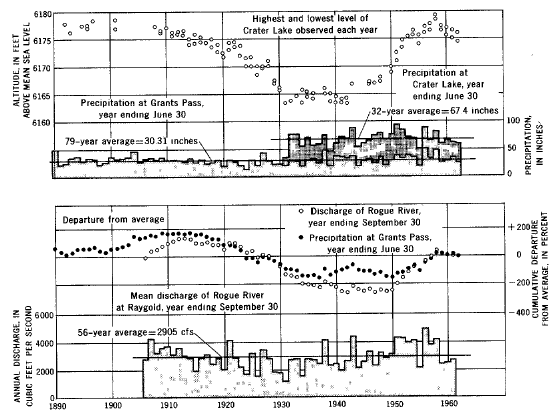 |
| FIGURE 4.-Altitude of water surface of Crater Lake; precipitation at Grants Pass and Crater Lake; departure from average for periods of record for flow of Rogue River at Raygold and precipitation at Grants Pass; and flow of Rogue River at Raygold. |
Attempts have also been made to ascertain whether Crater Lake has ever been much higher than at present by searching the slopes above the lake for sponge spicules and shells of diatoms of species that now live or could have lived in the lake. Pursuing that possibility, Nelson (1961, p. 33) collected soil samples at 100-foot altitude intervals up to the crater of Wizard Island, and up to the rim of Crater Lake. Nearly every sample, even those collected from places higher than the low points in the rim, contained diatoms and sponge spicules that must have been carried by wind currents to those levels far above the lake. Their presence is certainly not evidence of former high lake levels.