
Hydrology of Crater, East and Davis Lakes, Oregon by Kenneth N. Phillips
DAVIS LAKE
PHYSIOGRAPHIC AND GEOLOGIC SETTING
Davis Lake is a body of fresh water in Deschutes and Klamath Counties, 19 miles west of La Pine (fig. 1). It is an impoundment on Odell Creek, formed by a blocky, permeable lava flow of Holocene age that fills the channel and valley for a distance of 2 miles (fig. 8). The lake has no surface outlet.
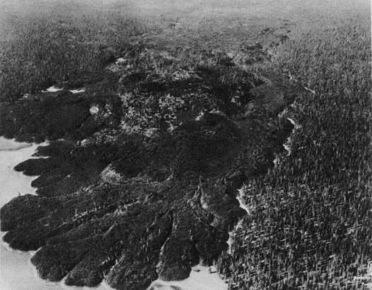 |
| FIGURE 8.-Lava flow that impounds Davis Lake; view looking northward in summer or early autumn of 1930. A forest road (not an outlet channel) skirts the east edge of the lava. Old beach at bottom center with a solitary tree was formed by a high-lake stage prior to the year 1723. Photograph by Delano Photographics. |
In 1878, Lt. T. W. Symons visited the area, and his report, quoted by Henshaw, Lewis, and McCaustland (1914, p. 16), gives the earliest known description of Davis Lake as follows:
This lake and valley were about 12 by 6 miles in size and took us completely by surprise, as they were evidently in the course of our West Fork [Deschutes River] and were not on any map. Reaching it, we found at its southern end many acres of rich grass and bunches of tall willows. Following around the west shore to the north end, we ascertained that there was no visible outlet. We saw the watermarks 20 feet above us on the lava bluffs of the northern and northwestern shores * * * We found the next day that these lava beds formed an impassable barrier extending unbroken for about 4 miles to the north, and at their end were again surprised to find, foaming out from underneath the giant boulders, the clear, cold river that we had seen lose itself in the lake * * *
Even then, the lake was called Davis Lake by the few people who knew of its existence. The reference by Lieutenant Symons to a 20-foot fluctuation in water level is no doubt a rough estimate (his estimated distances were about twice the actual distances), but obviously the lake was low when he saw it in 1878.
The lake was mapped in December 1934, and soundings were made by measuring from the ice surface at 4,380.8 feet. The bed of the lake at the lowest point was found to be at 4,367 feet, and the high-water line at the edge of the timber, 4,392 feet (C. C. Fisher, U.S. Bur. Reclamation, unpub. data, 1936). The area and volume of the lake for various levels, as computed from that survey, are given in figure 9.
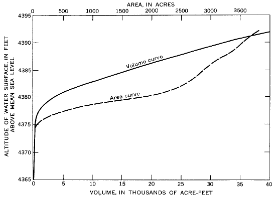 |
| FIGURE 9.-Area and volume of Davis Lake. |