
Klamath Network Water Quality Report (Phase II)
Section 3: Past Inventory, Monitoring, and Research Activities in the Klamath Network Park Units
| Redwood National and State Parks (RNSP) |
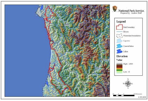 |
| Figure 8: Aquatic Resources and Watershed Boundaries of Redwood National and State State Parks, California, NPS Klamath Network |
General Summary of Past Activities: Redwood National and State Parks has monitored steam surface flow and sediment transport and deposition since 1972. The focus of these activities has been the long-term geomorphic and hydrologic monitoring of park unit freshwater lotic systems with emphasis on: (1) impacts due to human-related activities such as logging and road building; (2) water quality issues related to Clean Water Act section 303(d) impaired stream segments (i.e., Redwood Creek and Klamath River); (3) the impact of human-related activities on anadromous salmonids in park unit streams; and (4) the status of native amphibians in park unit lotic habitats. The status and trends of Redwoods marine ecosystems have been minimally examined. However, coastal and intertidal inventories are underway that are designed to assess, in part, human and invasive species impacts, offshore sediment budget, and potential impacts of perturbations such as oil spills to marine ecosystems.
Redwood National Park was established on October 2, 1968. It was designated a World Heritage Site on September 5, 1980, and a Biosphere Reserve on June 30, 1983. Redwood National Park joined three California State Parks (Prairie Creek Redwoods State Park, Del Norte Coast Redwoods State Park, and Jedediah Smith Redwoods State Park) as one cooperative management unit of the National Park Service and California Department of Parks and Recreation. In May 1994, Redwood National Park became Redwood National and State Parks (Figure 8), which contains approximately 45% of all remaining old-growth redwood forest in California. The parks are 42,701 ha (105,516 ac) in size arrayed along the Pacific Coast of northern California. The western boundary of Redwoods extends 0.4 km (0.25 mi) beyond the mean high tide line of the Pacific Ocean and the National Park Service has jurisdiction over the waters, intertidal lands, and submerged lands in this area. The coastal jurisdiction of state parklands extends 0.3 km (0.19 mi) west of the ordinary high-water mark of the Pacific Ocean. Elevations within the park range from below sea level to 996 m (3,268 ft).
The aquatic resources of Redwoods consist of over 60 km (36 mi) of marine coastal habitat and 547 km (340 mi) of USGS blue-line (first order) streams. Redwood Creek and its associated watersheds dominate the southern part of the park. The Klamath River is in the northern part of the park and the Klamath River estuary is the only part of the drainage contained within the park boundary. Redwood Creek supports a number of native salmonid species (i.e., cutthroat trout [Oncorhynchus clarki], coho salmon [Oncorhynchus kisutch], steelhead [Oncorhynchus mykiss], and chinook salmon [Oncorhynchus tshawytscha]) that are monitored on an annual basis. Green sturgeon (Acipenser medirostris), Klamath smallscale sucker (Catostomus rimiculus), and the tidewater goby (Eucyclogobius newberryi) are threatened and endangered fish species that also are monitored on an annual basis within the park. The park also supports a number of additional threatened and endangered species (see Appendix E of the KLMN Phase I Report).