
Klamath Network Water Quality Report (Phase II)
Attachment II: Aquatic Resources and Water Quality Questionnaire
1. Name of national park unit covered by this questionnaire:
2. Contact information for the principal person completing this questionnaire:
A. Name:
B. Position:
C. Telephone number:
D. Email address:
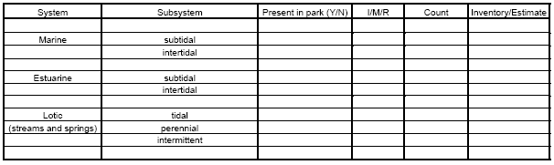
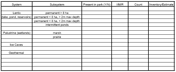
3. What aquatic resources are present within the park boundary (see next page for list of definitions); have any of these systems/subsystems been inventoried (I), monitored (M) or has research (R) been conducted within any of these systems/subsystems (respond in column 4 with an I, M, and/or R); provide the actual total count for each system/subsystem inventoried, or if not inventoried provide an estimated count, if possible, for each system/subsystem (column 5); in column 6, identify the source of the count in column 5 (I for Inventory, E for estimate).
 Definitions of terms associated with 3 above:3. continued
1. Marine System: open ocean
2. Subtidal Subsystem: substrate continuously submerged
3. Intertidal Subsystem: substrate is exposed and flooded by tides and includes associated splash zone
4. Lotic System: flowing water
5. Tidal Subsystem: channel gradient is low and water velocity fluctuates under tidal influence
6. Perennial Subsystem: water flows throughout the year
7. Intermittent Subsystem: channel contains flowing water for only part of the year. When water is not flowing, it may remain in isolated pools or surface water may be absent
8. Lentic System: ponds, lakes, and reservoirs
9. Palustrine System: all nontidal wetlands dominated by trees, shrubs, persistent emergent vegetation, emergent mosses or lichens, and all such wetlands that occur in tidal areas where salinity due to ocean-derived salts is below 0.5 0/00