
Despite recent storms average Oregon snowpack below average
New storm front on the way today
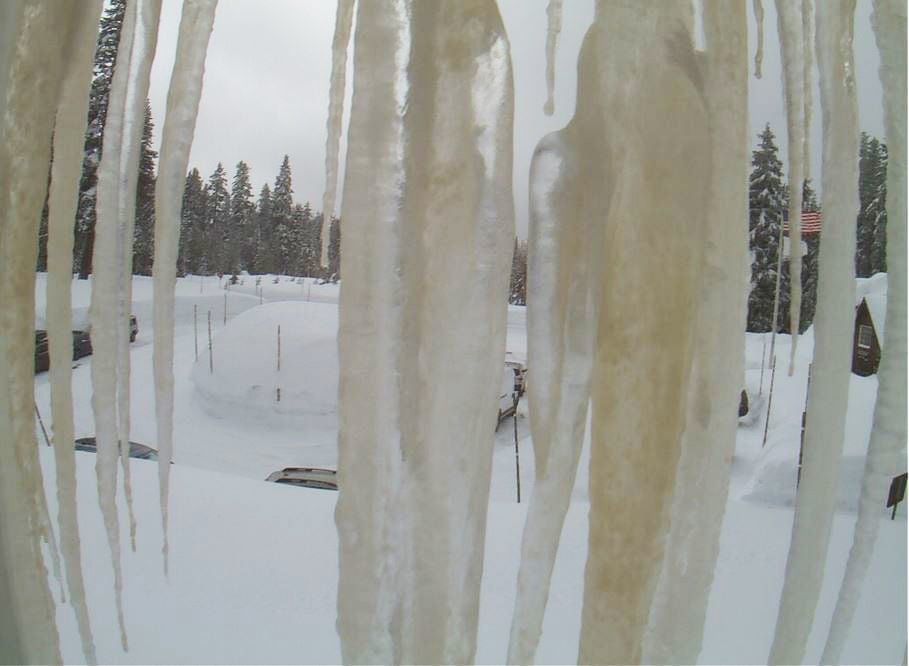
A view from Crater Lake National Park’s Steel Visitor Center webcam shows large icicles and a heavy snowpack as park officials brace for more snow storms this week.
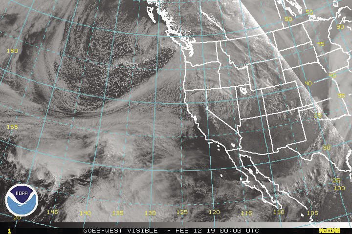
This National Oceanic and Atmospheric Administration weather satellite image taken Monday shows a storm system approaching the West Coast states.
Last weekend’s fresh flakes added to a healthy February for snowfall in Oregon, but most areas remain below average in snow levels and water year-to-date precipitation due to drier months at the start of the water year.
New snow flurries are in the forecast, beginning this afternoon and continuing through Wednesday morning. An incoming cold, wet weather system is predicted to bring heavy snow to the Cascades, Siskiyous and Mount Shasta area, according to a winter weather advisory issued Monday by the National Weather Service. Blowing snow is expected with total snow accumulations of 6 to 12 inches in the mountains and northern Klamath County along the highway 97 corridor, with 3 to 6 inches forecast in lower elevations for Klamath, Lake and Modoc counties. Winds gusts are forecast at as high as 50 mph creating occasional whiteout conditions.
So far, February has been promising for precipitation and snow-equivalent, yet is below-average snowfall for October through January, leaving most of the state below median averages.
At Crater Lake National Park as of Monday, there was a recorded snow level of 82 inches at park headquarters, 86 percent of average snow depth of 95 inches for this time of year. That level is predicted to rise this week, with forecasts predicting 4 to 8 inches to have fallen Monday, 11 to 17 inches on Tuesday, and 6 to 10 inches on Wednesday. Crater Lake has received a total snowfall since the start of the water year season of 203 inches, roughly 70 percent of the average of 288 inches for this time of year.
While Crater Lake National Park remains open 24 hours a day, several areas are currently closed due to winter conditions. Snow accumulation can cause closures for hours, sometimes for days and even weeks depending on the ability of park snowplow crews to clear roads.
Road closed
Presently the road from park headquarters to Rim Village is closed due to deep snow drifts, resulting in closure of the Rim Village Café and Gift Shop as well. Additionally, the north entrance road and rim drive are closed. Visitors can still enter through the south or west entrances on Highway 62. Any visitors should carry chains or traction tires.
“We are inching up towards being at averages, hopefully these next series of storms will add to the snowpack and amount we’ve had so far,” said Marsha McCabe, public information officer for Crater Lake National Park. “It has been encouraging to get some good snow this month. In 2017 we had an above-average snow year, but we still had two of the biggest fires we’ve ever had that summer; it takes a while to get caught back up after multiple drought years.”
Park officials stress that during winter months to check forecasts, as well as current road closures, before planning a trip to the park, as clouds may also obscure views of the lake. Crater Lake offers several webcams that show current conditions, and the visitor center is open from 10 a.m. to 4 p.m. with current road closure and weather information, available at 541-594-3000.
Tracking precipitation
Overall, as of Monday, the Klamath Basin reports 81 percent of median snowfall and 84 percent of average water year-to-date precipitation. The Rogue and Umpqua basins report lower levels, at 74 percent of median snowpack and 81 percent of average precipitation. The Willamette Basin is faring among the worst across the state, at only 66 percent of median snowfall. The Hood, Sandy and Deschutes basins are reporting in some areas as low as 43 percent of median snowfall.
Eastern Oregon is faring far better, with many sites at over 100 percent for median snowfall. Lake County and Goose Lake basin sites boast 115 percent of median snowfall, highest in the state, followed by the Malheur basin at 111 percent and John Day sites at 108 percent. Much of Eastern Oregon is at or just below median averages for snowfall and precipitation.
Snowpack and precipitation numbers are reported daily from various weather stations across the state provided through the Natural Resources Conservation Service. The U.S. National Weather Service station in Medford is forecasting a new storm front to enter Southern Oregon through Wednesday, with expected heavy mountain snow, strong winds, and heavy rain for elevations below 2,500 feet.
For current weather forecasts regionally visit www.weather.gov/mfr.
email kliedtke@heraldandnews.com @kliedtkeHN
***previous*** — ***next***