
Geologic History and Formation, USGS, 2002
from the United States Geological Service Website
Crater Lake partially fills a type of volcanic depression called a caldera that formed by the collapse of a 3,700 m (12,000 ft) volcano known as Mount Mazama during an enormous eruption approximately 7,700 years ago. The climactic (caldera-forming) eruption of Mount Mazama changed the landscape all around the volcano. Pyroclastic flows of pumice and ash devastated the surrounding area, including all of the river valleys that drained Mount Mazama to as far as 64 km (40 mi) away, and a blanket of pumice and ash fell to the northeast of the volcano at least as far as central Canada. Erosion removed much of this material, feeding rivers that carried it far from its source, ultimately into the Pacific Ocean. Prior to the climactic event, Mount Mazama had a 400,000 year history of activity similar to other Cascade volcanic centers such as Mount Shasta. Since the climactic eruption, there have been several less violent, smaller postcaldera eruptions within the caldera itself.
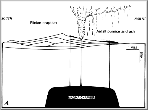
Mount Mazama was a large composite volcano constructed by episodic growth of many overlapping shield and composite volcanoes, each of which probably was active for a comparatively brief period. Mount Mazama rose to an approximate height of 3,700 m (12,000 ft) above sea level. The erupted magma was mainly andesite. The caldera wall displays the geologic layering of lava flows through time. As the volcanic complex evolved, so did its eruptive style. The eruptions of the last ~70,000 years were highly explosive; the eruptive magma were silica-rich (dacite and rhyodacite). The eruptions of the last ~30,000 years were less explosive; the eruptive magma were low in silica. The only activity in the 30,000 years record, prior to the caldera-forming climactic eruption of ~7,700 years ago, was limited to a small number of preclimactic pyroclastic eruptions and ensuing lava flows of rhyodacite.
Mount Mazama began its climactic eruption about 7,700 years ago, blowing out about 50 km3 (12 mi3) of magma as pyroclastic materials (mostly rhyodacite pumice and fine ash) in at most a few days. The volcanic ash covered parts of the northwestern states to as far as central Canada. Rare particles of Mazama ash have even been found in ancient ice from Greenland. The airfall pumice and ash covered a total surface area of more than 2,600,000 km2 (1,000,000 mi2) at least 1 mm (fraction of an inch) thick, and no less than 13,000 km2 (5,000 mi2) more than 15 cm (6 in) thick. A volume of 42-54 km3 (10-13 mi3) of the mountaintop had disappeared.