
Post-Eruptive History and Bathymetry of Crater Lake Highlights September Meeting 
NORTHERN CALIFORNIA GEOLOGICAL SOCIETY (NCGS) Newsletter, Spring 2003
View entire Report (PDF) post-eruptive-history
As Crater Lake celebrates its 100th year as a National Park, the NCGS (Northern California Geological Society) was fortunate enough to have a nationally recognized volcanologist discuss its caldera development and filling after the explosive eruption of Mount Mazama 7700 years ago. Dr. Charles R. Bacon of the USGS, Menlo Park, spoke to NCGS members September 25th on “Volcanism in Nature’s Bathtubs: The Caldera Lakes at Aniakchak and crater Lake.”
Dr. Bacon, a member of the USGS Volcano Hazards Team, has spent much of his research time studying the evolution of Crater Lake and contrasting its development to that of other recent andesitic volcanoes in the Circum-Pacific arc. This talk specifically focused on the post-caldera Holocene history of Aniakchak volcano on the Alaskan Peninsula (Aleutian volcanic chain) as a guide for evaluating the post- caldera processes at Crater Lake. And why Aniakchak crater? Because this volcano lies about 400 miles southwest of Anchorage along major commercial air routes that could be affected by volcanic ash ejected into the atmosphere during an eruption.
Aniakchak erupted catastrophically about 3500 years ago and has exhibited much post-caldera activity. It is considered active, and consists of a 10 km-wide by 0.5 to 1.0 km deep caldera that was formed during this major eruptive event. Since then, at least a dozen vents in the caldera have erupted, spewing out tephra (ash) and lava. Aniakchak last erupted in 1931, a violent event, and although there are no current signs of impending volcanic activity, it will erupt again in the future. Soon after the 3500 year old eruption, a lake formed in the caldera depression. One side of the caldera wall failed suddenly, and the lake drained rapidly down the Aniakchak River to the ocean nearby. Various geomorphic features associated with the drainage event, including conspicuous floodplain sediments deposited by the raging torrent and large 20 meter-sized boulders scattered along its path, attest to the sheer force and quantity of water released when the lake drained. The exposed caldera floor had been intruded by shallow dacite domes and phreatic (sputtering) eruptive events occurred periodically as magma invaded groundwater-enriched layers. This well preserved Alaskan eruptive event was used as a template by Dr. Bacon and his colleagues to interpret bathymetric features discovered on the bottom of Crater Lake, Oregon.
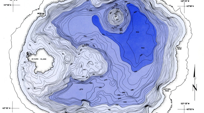
By comparison, the Crater Lake caldera measures 10 km. by 8 km. The 7700 year B.P. (before present) eruption scattered ash over eight states and three Canadian provinces, covering 5000 square miles with ejecta 6 inches deep! This massive series of eruptions were 42 times greater than 1980’s Mount St. Helens event. The eruption demolished 12,000 foot-high Mount Mazama, a volcano that had erupted intermittently for 500,000 years. The 3000-foot deep crater left after Mazama exploded was initially too hot to hold water but eventually filled over an estimated 700 year interval with snow melt and rain-water to a constant level controlled by evaporation and seepage. Annual fluctuations in lake level are no more than 3 feet. At a depth of 1932 feet, Crater Lake is the deepest lake in the United States and the seventh deepest in the world (Lake Baikal, which fills a 400 mile long continental rift valley in southern Siberia is the deepest at slightly over 1 mile).
Fascination with Crater Lake led t o three bathymetric surveys of the lake bottom since its discovery by gold prospectors in 1853. The first survey was conducted in 1886 by William Steel during a joint USGSU. S. Army expedition under Major Clarence Dutton. The survey was conducted using a Millers lead-line sounding machine, and the resulting map showed soundings only, and no contours. This effort was instrumental in getting Crater Lake established as a national park. The second survey was conducted in 1959 by the U.S. Coast and Geodetic Survey. It mapped the bathymetry of Crater Lake with an acoustic echo sounder using radar navigation. The contoured results are a fairly detailed map of the large-scale submarine lake features. By 1999, scientific interest in various aspects of the lake necessitated a better quality bathymetric map. High resolution multibeam mapping of the lake commenced in July, 2000, by the USGS Pacific Seafloor Mapping Project, at the request of the National Park Service. The survey boat had excellent GPS location capabilities and took 16 million soundings in 5 days. The details of this survey provide lucid evidence of volcanologic and geomorphic post-eruptive history of this landmark.
Dr. Bacon discussed in detailkey features revealed by the year 2000 bathymetric survey. Wizard Island is the most prominent feature in the crater, and along with the submerged Merriam cone, reflects renewed volcanism and intrusion, some subaqueous activity, after the caldera collapsed. There are several wave-cut benches around Wizard Island and the lake perimeter that mark former climate-influenced water levels. Lava deltas emptied off the flanks of Wizard Island, and massive landslides slid off the caldera walls; the most obvious is the 300-meter wide block that avalanched into Chaski Bay. Details of former lake levels can be seen in the high resolution bathymetry. Today there are also some high heat flow regions on the lake bottom that feed brine pools and support algal mat communities. Eruption rates determined for post-caldera activity agree with rates estimated for recent island arc volcanism in the Pacific Arc, West Indies, and Indonesia. The Crater Lake caldera story has been repeated several times in the Cascade Range from Mount Lassen in northern California to southern British Columbia. A buried caldera lies hidden near Mount Baker in Oregon. Another interesting facet of Cascade Range dynamics is the paucity of subaerial volcanism compared with shallow level plutonic intrusive activity. These observations are linked to offshore subduction processes and complex plate tectonic interactions along the Pacific Northwest.
The NCGS offers its sincerest thanksto Dr. Charles Bacon for sharing his experiences exploring the Crater Lake caldera floor. His talk provided a unique perspective on one of America’s most beautiful and cherished national landmarks. More information on Crater Lake and these bathymetric surveys can be found at http://walrus.wr.usgs.gov/pacmaps/cl-index.html and http://www.aqd.nps.gov/grd/parks/crla/
Other pages in this section
*** previous title *** --- *** next title ***