
Hydrologic Benchmark Network Stations in the Western U.S. 1963-95 (USGS Circular 1173-D)
Site Characteristics and Land Use
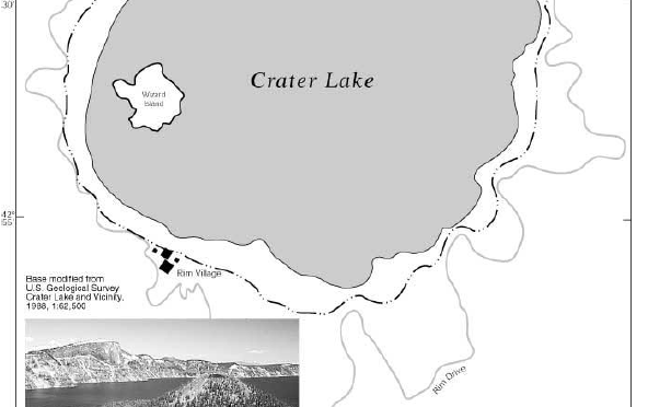
Crater Lake is located in the Sierra-Cascade Mountains physiographic province along the crest of the Cascade Range in southwestern Oregon (Figure 18. Map showing the Crater Lake Basin and photograph showing Wizard Island and crater rim). Crater Lake occupies the collapsed caldera of Mount Mazama and has an average surface elevation of 1,882 m, a surface area of 53.2 km2, and a maximum depth of 589 m (Larson and others, 1993). The 67.8-km2 drainage basin consists of the lake (53.2 km2) and the steep walls of the caldera (14.6 km2), which reach a maximum elevation of 2,484 m (Larson and others, 1996). The HBN station is located along the northeast shore of the lake in Cleetwood Cove at latitude 42°58’45” and longitude 122°04’45”. The lake receives 85 percent of its inflow by direct precipitation, and the remainder comes from about 40 springs and streams that emanate from the caldera walls (Redmond, 1990). There is no surface flow out of the lake, and the lake level is maintained by a balance between evaporation (28 percent) and seepage from the lake bottom (72 percent) (Redmond, 1990). The lake elevation varies annually by about 60 cm in response to seasonal variations in precipitation and vaporation. The minimum and maximum lake elevations on record were 1,878.5 m on September 10, 1942, and 1,883.5 m on March 25, 1975 (Hubbard and others, 1996). The climate of Crater Lake is discussed in detail by Redmond (1990). Average monthly air temperatures range from -3.5°C in January to 12.8°C in August (URL http://www.wrcc.sage.dri.edu, accessed 1998). Precipitation averages 172 cm annually and is strongly seasonal; December (28.9 cm) and January (10.6 cm) are the wettest months and July (2.1 cm) and August (2.4 cm) are the driest. Winter snowfall averages 1,350 cm/yr and accumulates in a seasonal snowpack between November and March that usually reaches 300 cm in depth. Despite the large amount of snow, the lake almost always remains free of ice and snow during winter.
The basin is in the subalpine zone of the Sierran Steppe ecoregion (Bailey and others, 1994). Vegetation on the crater rim is dominated by mature conifer forests of mountain hemlock, red fir, and whitebark pine (Gregory and others, 1990). Small shrubs, herbaceous plants, and Sitka alder grow in thickets along springs and seeps that emanate from the crater walls. A description of the ecology of the lake itself is beyond the scope of this report but can be found in Drake and others (1990) and Larson and others (1993).
The geologic setting and history of Crater Lake are summarized by Bacon and Lanphere (1990). Crater Lake partly fills an 8- by 10-km-diameter caldera that collapsed during the eruption of Mount Mazama about 6,850 years ago (Bacon and Lanphere, 1990). The walls of the caldera consist of andesitic and dacitic lavas that primarily consist of plagioclase (An50), pyroxene, and sodium-rich volcanic glass (Nathenson and Thompson, 1990). The floor of the caldera is filled by intercaldera tuffs and interbedded landslide deposits that are covered by a thin layer of lake sediment. The lake sediment represents a mixture of material from three sources-volcanic debris from the caldera walls, biogenic particulates that settle out from the lake water, and iron oxide precipitates that form where hydrothermal fluids vent from the lake floor (Dymond and Collier, 1990). Soil development on the crater walls is hindered by steep slopes and frequent avalanches, and most of the slopes are covered by loose accumulations of gravel, cobbles, and boulders (Gregory and others, 1990).

Figure 18. Map showing the Crater Lake Basin and photograph showing Wizard Island and crater rim
The Crater Lake HBN Basin is located in Klamath County in Oregon and is entirely in the boundaries of Crater Lake National Park. The park was established in 1902, and more than 90 percent of the park is managed as wilderness (U.S. Department of the Interior, 1995). A 53-km paved road, referred to as Rim Drive, follows the crater rim around the perimeter of the lake. The road is closed each year in mid-October because of winter snows and is plowed each spring, beginning in mid- April, to reach the north entrance of the park by mid-June. During the snow-free months, the only access to the shore of the lake is from a steep 1.8-km hiking trail between Rim Drive and the boat ramp at Cleetwood Cove. More than 500,000 people visit the park annually; the heaviest use is in July and August. The only park facilities in the basin boundary are a visitor center, a lodge and cafeteria, a sewage-disposal facility at Rim Village on the south side of the lake, several picnic areas along Rim Drive, and a research station on Wizard Island. The sewage-disposal facility at Rim Village consists of a septic tank that discharges as much as 62,000 m3 of domestic wastewater each year into a drainfield that is situated 200 m above the surface of the lake (Larson and others, 1990). Recent studies of the chemistry of springs emanating from the crater walls indicate that the drainfield has increased nitrate concentrations in springs below the Rim Village that discharge directly into the lake (Larson and others, 1990).
In response to indications that the clarity of the lake might be declining, the U.S. Congress mandated a 10-year limnological study of Crater Lake (Public Law 97-250) in the fall of 1982 (Larson, 1990). The goals of the study were to develop a reliable data base for the lake, improve understanding of lake components and processes, establish a long-term program to monitor changes in the lake, and determine if the lake had changed in response to environmental stressors (Larson and others, 1993). The study concluded that long-term changes in lake clarity could not be verified because of the lack of historical data but identified climate change, air pollution, onsite automobile and boat use, and nonnative fish as the greatest human-related threats to the ecosystem. The results of scientific investigations conducted as part of this limnological program are compiled in a technical report published by the National Park Service in 1993 (Larson and others, 1993).
***previous *** — ***next ***