
Klamath Network Water Quality Report (Phase II)
Section 3: Past Inventory, Monitoring, and Research Activities in the Klamath Network Park Units
| Lava Beds National Monument (LABE) |
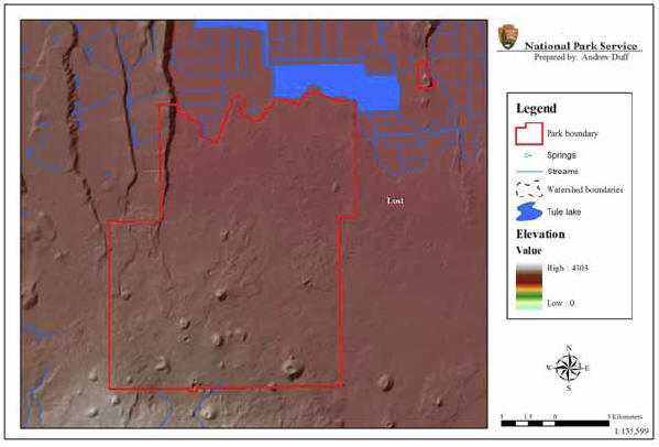 |
| FIGURE 5: Aquatic Resources and Watershed Boundaries of Lava Beds National Monument, California, NPS Klamath Network |
General Summary of Past Activities: Aquatic resource inventory, monitoring and research activities at Lava Beds National Monument have included surveys of ice cave baseline water quality, monitoring of ice depth, and monitoring of groundwater depth and availability. Lava Beds is also concerned about the potential effects of adjacent land use practices (e.g., agriculture and geothermal exploration and development) on park unit aquatic resources.
Lava Beds National Monument (Figure 5) was established by Presidential Proclamation on November 21, 1925 to preserve for public enjoyment the area’s dramatic volcanic geology (e.g., lava tubes, cinder cones, spatter cones, lava flows and other volcanic phenomena). Lava Beds was originally placed under the jurisdiction of the Department of Agriculture, U.S. Forest Service, and was transferred to the Department of the Interior on June 10, 1933.
The 18,842 ha (46,560 ac) monument is located on the east-side of the Southern Cascade Mountains on the Modoc Plateau in northeastern California. The plateau is a volcanic platform generally ranging in elevation between 1219–1829 m (4,000-6,000 ft). Lava Beds lies on the northern flank of Medicine Lake Volcano. The volcano is a Pleistocene to Holocene shield volcano located about 48.3 km (30 mi) northeast of Mt. Shasta and the eruptive area of the Medicine Lake Volcano covers over 233 km2 (900 mi2). There is evidence of glaciation at the higher elevations of the volcano. LABE contains a range of Great Basin vegetation communities, including ponderosa pine forests, mountain mahogany/juniper, and sagebrush/bunchgrass.
Lava Beds currently has 502 documented lava tube caves with a total of 46.2 km (28.7 mi) of known passageways. Due to the porosity of lava soils, no permanent ponds, lakes, streams or wetlands are found within the monuments boundary. However, 28 caves within the monument are documented to contain ice and water, and seasonal (intermittent-ephemeral) ponds can be formed after heavy precipitation events. Many of the ice caves are important water sources for wildlife and have been historically used by humans (e.g., indigenous groups, ranchers and moonshiners). Fourteen species of bats and a number of bird species utilize the ice caves as sources of water. Two of the bat species include Townsend’s big eared bat (Corynorhinus townsendii) which is a species of concern, and the largest northern migratory United States colony of the Mexican freetail bat (Tadarida brasiliensis).
There are no distinct aquifers in the area, so there is uncertainty about the source, quantity and movement of groundwater in Lava Beds. One groundwater well, located at the monument headquarters, provides water for all staff and visitors. The U.S. Geological Survey is monitoring groundwater at five wells, four in the monument and one outside the monument boundary. There appears to be some groundwater drawdown due to agricultural land use near the monument. The National Park Service Water Resources Division also is helping to evaluate the status of groundwater at Lava Beds.