
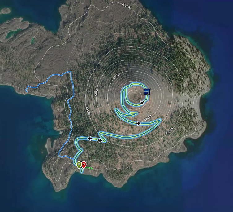
Wizard Island Summit Trail – Crater Lake National Park
 Crater Lake Institute partners with REI’s Hiking Project app and website which features 3-D maps, user photos, current conditions and trail descriptions. If you go to them for information, please come back here.
| Time: 1 hour
Difficulty: moderate Length: .9 mi (1.45 km) roundtrip Elevation: 6175* – 6873† ft (1882* – 2095† m) |
Trailhead coordinates:
Latitude: N +42° 56.06 or 42.93436 Longitude: W -122° 09.02 or -122.15045 Altitude: 6175* ft (1882* m) |
| Highlight: spectacular lake views, interesting geology (summit crater) | |
* Wizard Island boat dock † Wizard Island summit
Trail Description
|
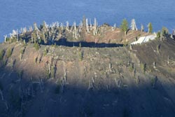
Wizard Island crater from the Watchman, Photo by Robert Mutch |
This trail is a rocky climb to the top of Wizard Island with a path leading around the 90-foot-deep (27-meter) crater summit. Visitors who want to hike on Wizard Island must first descend to the lakeshore via Cleetwood Cove Trail. This is a steep descent and the most difficult portion of this trek will be at the end of the day when you must ascend the 11% grade to Rim Drive. The trek to Wizard Island’s summit is a full day trip.
The commercial tour boat will take visitors to the Wizard Island boat dock where the trail to the summit begins. The boat will pick you up later that same day as overnight stays on the island are not allowed. The tread ascends northeastward from the dock steadily at first. A short distance from the trailhead the terrain steepens and switchbacks lead hikers to the 6,940-foot summit of Wizard Island.
The buildings on the south shore of Wizard Island house the tour boats during the off-season and serve as home port for the National Park Service research vessel Neuston.
Trailhead location: Wizard Island dock, accessible via boat tour from Cleetwood Cove.
Seasonal Information: Expect the trail to be covered in snow from October to early July, however, conditions vary somewhat from year to year. See Crater Lake Current Conditions for more information. The “volcano boat cruising” season typically begins late June/early July and ends late September/early October. See Crater Lake Lodges volcano boat cruise information.
RelatedMammals on Wizard Island, Nature Notes From Crater Lake, 1937 Wizard Island, An Index to the Past?, Nature Notes From Crater Lake, 1954 The Pools of Wizard Island, Nature Notes From Crater Lake, 1933 |
Flora: Of the six tree species (all conifers), on Wizard Island, the Western Hemlock (Tsuga mertensiana) predominates on the lower half of the island while the timberline White Bark Pine (Pinus albicaulis Engelm.) has the same predominance at the summit of the cone, where it characteristically encircles the crested rim of the Wizard crater. Within the crater, and especially at its bottom, where soil and moisture conditions are of the most favorable for their growth and maintenance, are to be found some of the more shallow rooted forms, such as grasses, sedges, rushes and Tolmie’s Saxifrage (Saxifraga tolmiei). [The Flora of Wizard Island, Nature Notes From Crater Lake, Vol. 7, No. 1, 1934]
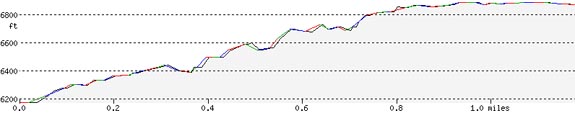
Wizard Island Summit Trail Elevation Profile
Related Maps
Digital USGS topographic maps (PDF files) – the following maps are relevant to the Wizard Island Summit trail. See more Crater Lake Institute online USGS digital maps.
| Series | Name | Year | Scale | Contour Interval | File |
| USGS 7.5′ | Crater Lake West | 1985 | 1:24,000 | 40 ft | usgs-crater-lake-west-7.5 |
| USGS 30′ x 60′ | Crater Lake | 1989 | 1:100,000 | 50 m | usgs-crater-lake-30-minute |
| USGS 30′ x 60′ | Diamond Lake | 1978 | 1:100,000 | 50 m | usgs-diamond-lake-30-minute |
| USGS 1° x 2° | Klamath Falls | 1970 | 1:250,000 | 200 ft | usgs-klamath-falls-1-2 |
| USGS 1° x 2° | Medford | 1976 | 1:250,000 | 200 ft | usgs-medford-1-2 |
| USGS 1° x 2° | Roseburg | 1970 | 1:250,000 | 200 ft | usgs-roseburg-1-2 |
|
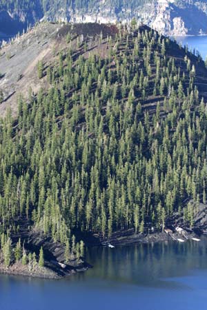
Wizard Island, the landing boat docks are at the bottom of the photo and the trail to the summit moves upward, Photo by Robert Mutch |
|
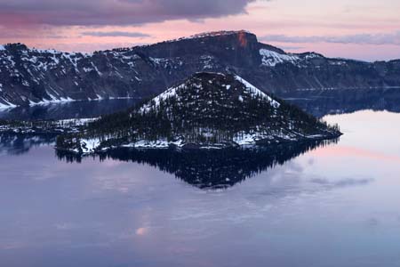
Sunset, Wizard Island, facing northwest, from Garfield Peak trail, Llao Rock in background, Photo by Robert Mutch |
|
Please remember to practice “leave no trace outdoor ethics” when you are out on Crater Lake National Park’s trails…and have fun! |
Other pages in this section
- Pacific Crest Trail
- Anderson Bluffs Trail
- Anne Creek Canyon Trail
- Anne Springs Cutoff Trail
- Bald Crater Loop Trail
- Bert Creek Trail
- Boundary Springs Trail
- Castle Crest Wildflower Trail
- Cleatwood Cove Trail
- Crater Peak Trail
- Discovery Point Trail
- Dutton Creek Trail
- Fumarole Bay Trail
- Garfield Peak Trail
- Godfrey Glenn Trail
- Lightning Spring Trail
- Llaos Hallway
- Mount Scott Trail
- Park Headquarters Historic Trail
- Pinnacles Valley Trail
- Plaikni Falls Trail
- Pumice Flat Trail
- Stuart Falls Trail
- Sun Notch Trail
- Union Peak Trail
- Watchman Peak Trail
- Hiking Rules and Regulations
- Best Trails at Crater Lake