
Cleetwood Cove Trail – Crater Lake National Park
| Time: 1 hour
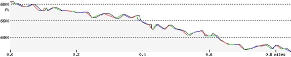
Difficulty: Strenuous Length: 1.1 mi (1.77 km) Elevation: 6175* – 6831 ft (1882* – 2082 m) |
Trailhead coordinates:
Latitude: N +42° 58.78 or 42.934217 Longitude: W -122° 04.99 or -122.08320 Altitude: 6831 ft (2082 m) |
| Highlight: swimming, fishing, boat tours; Access to lake shore and boat landing | |
*boat landing
RelatedHow Deep is Crater Lake…Really? by Owen F. Hoffman Crater Lake Clarity: It doesn’t get any better than this, by Scott F. Girdner Crater Lake…Unique?, Nature Notes From Crater Lake, 1993 |
Trail Description
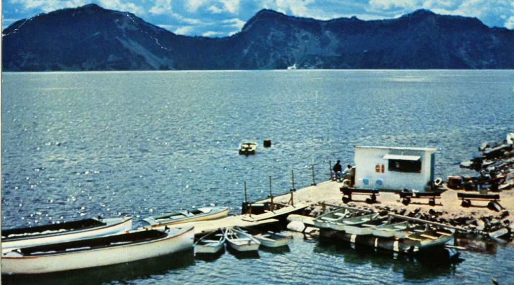
The only legal access to the shore of Crater Lake, this is a strenuous and steep switchback trail with a steep grade (11%). The trail descends to a rocky shoreline at Cleetwood Cove where concessionaire tour boats will take you around the lake or drop you off at Wizard Island. The trail is recommended only for those in good physical condition. It should not be attempted by anyone with heart, breathing, or walking problems. It is not accessible for people with mobility impairments. Hikers should wear sturdy shoes and carry water. Vault toilets are located at the top and bottom of the trail.
The trail leading to Cleetwood Cove begins along East Rim Drive approximately four and a half miles east of North Junction. The route begins on the right side of Rim Drive at an elevation 6,850 feet.
Trailhead location: North side of the lake, 11 miles (17.6 km) from Rim Village if traveling clockwise on Rim Drive. Parking area 4.5 miles east of North Junction
Seasonal Information: Expect the trail to be covered in snow from October to July, however, conditions vary somewhat from year to year. The “volcano boat cruising” season typically begins late June/early July and ends late September/early October. See Crater Lake Lodges volcano boat cruise information.
Nature Note: Below 200 feet (61 meters), the water in Crater Lake stays 38 degrees F (3 degrees Celsius) year-round.
Historical Note: the Cleetwood Cove Trail first opened during the summer of 1960.
Cleetwood Cove Trail Elevation Profile
Related Maps
Digital USGS topographic maps (PDF files) – the following maps are relevant to the Cleetwood Cove trail. See more Crater Lake Institute online USGS digital maps.
| Series | Name | Year | Scale | Contour Interval | File Size |
| USGS 7.5′ | Crater Lake East | 1985 | 1:24,000 | 40 ft | usgs-crater-lake-east-7.5 |
| USGS 30′ x 60′ | Crater Lake | 1989 | 1:100,000 | 50 m | usgs-crater-lake-30-minute |
| USGS 30′ x 60′ | Diamond Lake | 1978 | 1:100,000 | 50 m | usgs-diamond-lake-30-minute |
| USGS 1° x 2° | Klamath Falls | 1970 | 1:250,000 | 200 ft | usgs-klamath-falls-1-2 |
| USGS 1° x 2° | Medford | 1976 | 1:250,000 | 200 ft | usgs-medford-1-2 |
| USGS 1° x 2° | Roseburg | 1970 | 1:250,000 | 200 ft | usgs-roseburg-1-2 |
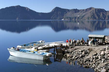 The 30-year old Cleetwood Cove boat landing, looking south towards Sun Notch. The new dock, built in 2014 for a cost of over a $1,000,000 lasted one season before its foundation cracked. Photo by Robert Mutch |
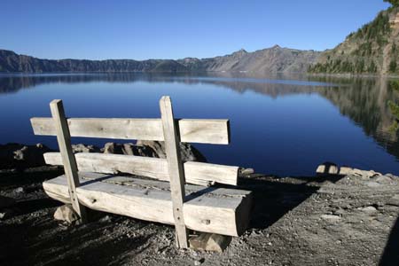 Rustic bench at the Cleetwood Cove boat landing, looking southwest towards Wizard Island, Watchman Peak, and Hillman Peak, Photo by Robert Mutch |
|
Please remember to practice “leave no trace outdoor ethics” when you are out on Crater Lake National Park’s trails…and have fun! |
Other pages in this section
- Pacific Crest Trail
- Anderson Bluffs Trail
- Anne Creek Canyon Trail
- Anne Springs Cutoff Trail
- Bald Crater Loop Trail
- Bert Creek Trail
- Boundary Springs Trail
- Castle Crest Wildflower Trail
- Crater Peak Trail
- Discovery Point Trail
- Dutton Creek Trail
- Fumarole Bay Trail
- Garfield Peak Trail
- Godfrey Glenn Trail
- Lightning Spring Trail
- Llaos Hallway
- Mount Scott Trail
- Park Headquarters Historic Trail
- Pinnacles Valley Trail
- Plaikni Falls Trail
- Pumice Flat Trail
- Stuart Falls Trail
- Sun Notch Trail
- Union Peak Trail
- Watchman Peak Trail
- Wizard Island Summit Trail
- Hiking Rules and Regulations
- Best Trails at Crater Lake