
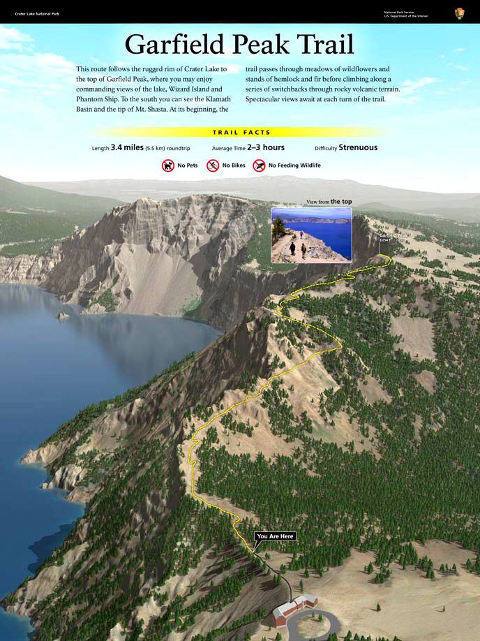
Garfield Peak Trail – Crater Lake National Park
| Time: 2.5 hours
Difficulty: Difficult Length: 1.7 mi (2.74 km) Elevation: 7090 – 7976 ft (2161 – 2431 m) |
Trailhead coordinates:
Latitude:N +42° 54.57 or 42.934217 Longitude: W -122° 08.41 or -122.14020 Altitude: 7090 ft (2161 m) |
| Highlight: Panorama of surrounding area, excellent views of Crater Lake, occasional small animals, wildflowers, and an overhead view of Phantom Ship | |
REI Trails Project partners with Crater Lake Institute to produce their trails app. Click the map below, get the app – then come back, we offer more.
Trail Description
|
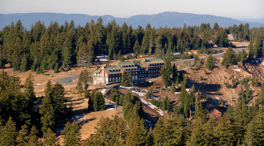
Lower section of the Garfield Peak trail with Crater Lake Lodge in background, facing west, Photo by Robert Mutch |

This is the one of the most popular hiking trails, primarily due to it’s close proximity to the Rim Village and Crater lake Lodge. There are spectacular panoramic views of the entire lake and other high cascades features to the north and to the south the Klamath Basin and southern Cascade features. 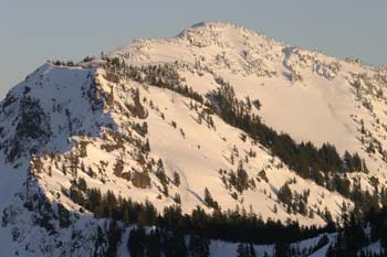
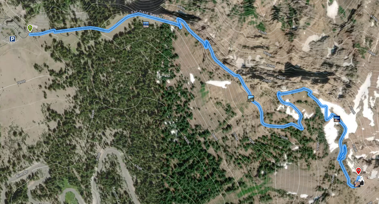
The trail leads eastward contouring the ridge above Crater Lake. The track turns northward one half mile from the trailhead and begins to climb. It ascends the northwestern ridge of Garfield Peak then turns eastward. Gaining the northern ridge crest the route continues to climb to the 8,060-foot summit. Views from this lofty peak south of Crater Lake include the lake, Phantom Ship and terrain south. There is a good path to the top, but, be prepared for a difficult climb along this trail.
Trailhead location: East end of Rim Village. Walk behind Crater Lake Lodge along the paved promenade and continue upwards to a dirt trail. East of the Crater Lake Lodge, along the caldera rim
Nature Note: Hemlocks and some Shasta red fir trees dominate the bottom portion of the trail and the top comes to be dominated by Whitebark pines and subalpine firs. Rocky slopes along the trail are home to American pikas and yellow-bellied marmots.
Seasonal Information: Expect the trail to be covered in snow from October to early July, however, conditions vary somewhat from year to year. The top portion of the trail may be covered in snow until late-July.
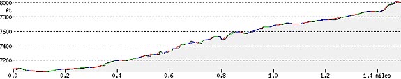
Garfield Peak Trail Elevation Profile
Related Maps
Digital USGS topographic maps (PDF files) – the following maps are relevant to the Garfield Peak trail. See more Crater Lake Institute online USGS digital maps.
| Series | Name | Year | Scale | Contour Interval | File Size |
| USGS 7.5′ | Crater Lake East | 1985 | 1:24,000 | 40 ft | usgs-crater-lake-east-7.5 |
| USGS 7.5′ | Crater Lake West | 1985 | 1:24,000 | 40 ft | usgs-crater-lake-west-7.5 |
| USGS 30′ x 60′ | Crater Lake | 1989 | 1:100,000 | 50 m | usgs-crater-lake-30-minute |
| USGS 30′ x 60′ | Diamond Lake | 1978 | 1:100,000 | 50 m | usgs-diamond-lake-30-minute |
| USGS 1° x 2° | Klamath Falls | 1970 | 1:250,000 | 200 ft | usgs-klamath-falls-1-2 |
| USGS 1° x 2° | Medford | 1976 | 1:250,000 | 200 ft | usgs-medford-1-2 |
| USGS 1° x 2° | Roseburg | 1970 | 1:250,000 | 200 ft | usgs-roseburg-1-2 |
Trail Guide (from the Garfield Peak Trail Guide published by the Crater Lake Institute)
(1) Crater Lake Lodge – Construction of the Crater Lake Lodge began in 1909 but was never completed as planned. In late 1989 it was closed for reconstruction and reopened in 1995.
(2) Launching the Cleetwood – Looking down into the caldera just before leaving the asphalt trail, one can observe a narrow canyon that the Cleetwood boat was launched in July of 1886. Using cables anchored to trees, men slid it and themselves down snowbanks that reached to the water’s edge. The Cleetwood was used to take the first soundings of the lake as part of the first scientific exploration of Crater Lake.
(3) Shady Mountain Hemlock forest – This portion of the trail enters a shady Mountain hemlock (Tusga mertensiana) overstory. You will also find sub-alpine fir (abies lasiocarpa), and the prostrate Crater Lake currant (Ribes erythrocarpum) covers the ground. Staghorn lichen (Letharia vulpina), the bright yellow filamentous growth on the barks of trees is a symbiotic growth between fungus and algae, The absence of this lichen on the lower trunk is an indication of winter snow level.
(4) grassy pumice field – Here you enter a large open grassy pumice field that in early summer is filled with an ever changing display of wildflowers, lupines (Lupinus sp.). Newberry’s knotweed (Polygonum Newberryi), spreading phlox (Phlox diffusa), and rabbit brush (Chrysothamnus nauseosus). This pumice field accumulates deep snow reducing the encroachment of conifer seedlings: the tree borders favor wildlife.
(5) First wooden bench – The first wooden bench and railing is a good place to inspect the inner slopes of the caldera’s south rim. Notice the complex rock buttresses above the trail – This serrated ridge of volcanic rock is known as Castle Crest. Much of this material was so hot when it erupted that it partially fused together. These rocks formed long before the climactic event which formed the caldera. The trail offers spectacular views of Wizard Island along with the west and north portions of the caldera rim, which included the Watchman, Hillman Peak, Devil’s Backbone and Llao Rock.
(6) ground vegetation – As the trail progresses across the upper slopes of Munson Valley ground vegetation is composed of the holly-like creeping ceanothus (Ceanothus prostratus) interspersed with shrub-like ocean spray (Holodiscus dumosus). There are abundant examples of pearly everlasting (Anaphalis margaritacea), umbellate pussy paws (Calyptridium umbellatum), and sulfur eriogonum (Eriogonum umbellatum). Near the base of the stone facade of the Garfield Reservoir is the waxy shrub known as sticky currant (Ribes viscosissimum). Rub a leaf and enjoy the aroma.
(7) Reservoir – Stone covered reservoir, the water supply for Rim Village. This is an excellent observation platform to view the south facing slope of Mt. Mazama and Munson Valley below. Look to the southwest at Union Peak, one of the most prominent points in teh park. At 7,700 ft (2,350 m) it is the remnant core of an ancient shield volcano formed almost entirely from successive basaltic lava flows. Glaciers have eroded its summit spire. Further south, the perfect pyramid of Mount McLoughlin, a strato-volcano, dominates the horizon. Mount McLoughlin formed from alternate eruptions of lava and pyroclastics, much like Mount Mazama and other high Cascade volcanoes.
(8) Garfield Peak Summit – You are now just a few steps from the summit, be prepared for high winds, cooler temperatures, and a need for extra clothing. The summit of Garfield Peak is 8,060 ft (2,460 m) feet above sea level. You have climbed nearly 1,000 feet (300 m) in elevation above Rim Village to obtain panoramic views to all sectors of the compass. More than a hundred air miles (160 km) south lies the snow covered slopes of Mount Shasta in California. Mt. Shasta is 14,161 ft (4,137 m) stratovolcano similar to Mount Mazama, but much larger. Ninety miles (145 km) north, just barely visible over the north horizon is the top of another high strato-volcano, the South Sister (10358 ft or 3,157 m) situated just west of Bend, Oregon.
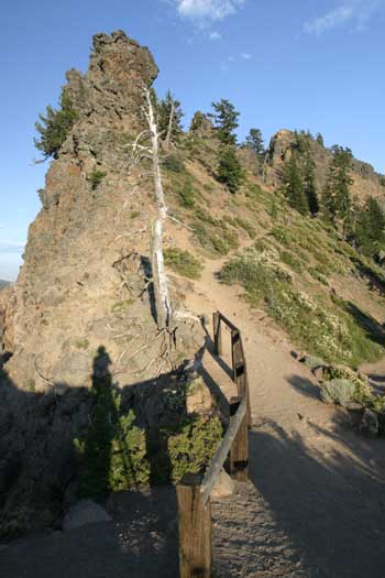 Garfield Peak trail, facing upwards and east, photo by Robert Mutch Garfield Peak trail, facing upwards and east, photo by Robert Mutch |
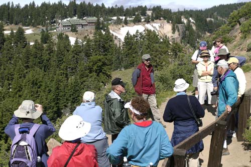 A group of Crater Lake visitors is guided by the Crater Lake Institute’s founder and President, Ron Mastrogiuseppe, Garfield Peak trail, facing southwest with the Crater Lake Lodge in the background (upper left corner), photo by Robert Mutch A group of Crater Lake visitors is guided by the Crater Lake Institute’s founder and President, Ron Mastrogiuseppe, Garfield Peak trail, facing southwest with the Crater Lake Lodge in the background (upper left corner), photo by Robert Mutch |
|
Please remember to practice “leave no trace outdoor ethics” when you are out on Crater Lake National Park’s trails…and have fun! |
Other pages in this section