
Weather and Climate Inventory, Klamath Network, National Park Service, 2007
2.0. Climate Background
2.2. Spatial Variability
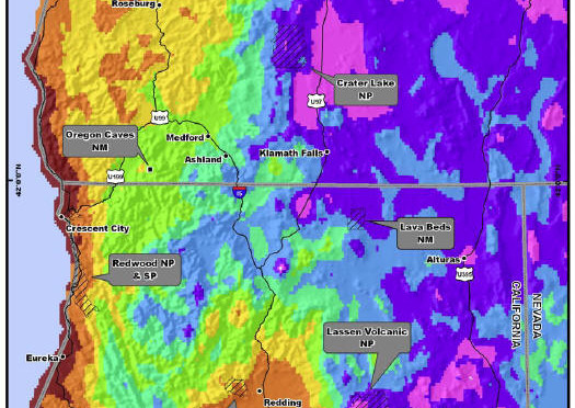
Precipitation characteristics of the KLMN are defined by the superimposed effects of topography and coast-interior gradients. Precipitation generally increases to the west and as a function of elevation in the KLMN. The wettest park unit in the KLMN is REDW, where mean annual precipitation totals exceed 2000 throughout much of the park unit (Figure 2.1; Odion et al. 2005) Park units with high-elevation settings, such as CRLA and LAVO, also have high annual precipitation totals. LAVO also has one of the most extreme precipitation gradients of any of the KLMN park units, with mean annual precipitation totals ranging from under 750 mm in eastern LAVO to near 3000 mm at the highest elevations of the park unit. In contrast to these wet locations, LABE is the driest park unit in the KLMN, with a mean annual precipitation of under 500 mm across the park unit. This park unit is located in the rain shadow of the northern California mountains. Much of the precipitation in KLMN park units occurs during the winter months (Figure 2.2), with some interior locations possibly receiving a secondary precipitation maximum during the spring months (e.g., see Figure 2.2c). Since much of the precipitation in the KLMN falls during the winter months, this precipitation falls in the form of snow for the higher elevation park units like CRLA and LAVO, where mean annual snowfalls can exceed 15 m (Figure 2.3). Crater Lake records some of the heaviest snow in the U.S. each winter, with annual totals averaging over 13 m (Odion et al. 2005; Redmond 2007).
Mean annual temperatures across the KLMN generally follow a northeast-southwest gradient (Figure 2.4). This temperature pattern is composed of at least three components. First, temperatures generally become milder closer to the coast. Latitudinal gradients are a second contributor, with warmer conditions towards the south. Finally, mean annual temperatures in the KLMN also vary as a function of elevation, with the coolest conditions observed in the higher elevations of the Cascade Mountains. The coolest park unit in the KLMN is CRLA, where mean annual temperatures are below 3°C across much of the park unit. The warmest park unit in the KLMN is WHIS, with mean annual temperatures that can exceed 15°C at lower elevations west of Redding. Near the coast, in REDW, mean annual temperatures are around 10°C. The coast interior climate gradients in temperature are well-defined during the winter and summer months.
Figure 2.1. Mean annual precipitation, 1961-1990, for the KLMN.
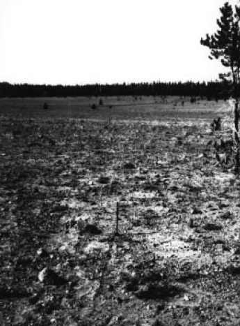
Figure 2.2. Mean monthly precipitation at selected locations in the KLMN. Locations include REDW (a), CRLA (b), and LABE (c).
Figure 2.3. Mean annual snowfall, 1961-1990, for the KLMN.

Figure 2.4. Mean annual temperature, 1961-1990, for the KLMN.
During January, portions of REDW have minimum temperatures that generally don’t get below 3°C, while higher elevations of CRLA and LAVO get down below -10°C regularly (Figure 2.5). In July, however, this temperature gradient goes in the opposite direction. While portions of REDW regularly struggle to get above 16°C for daytime maximum temperatures, lower elevations of WHIS often get above 34°C (Figure 2.6) and occasionally exceed 40°C during heat waves. Topographical effects and north-south gradients are also apparent during the summer months. The higher-elevation park units (e.g., CRLA, LAVO) are still coolest.
Figure 2.5. Mean January minimum temperature, 1961-1990, for the KLMN.

Figure 2.6. Mean July maximum temperature, 1961-1990, for the KLMN.
Other pages in this section
*** previous title *** --- *** next title ***