
Volcano and Earthquake Hazards in the Crater Lake Region, Oregon
Earthquakes
West Klamath Lake Fault Zone
Mount Mazama lies at the north end of the fault bounded basin known as the Klamath graben. North of Klamath Falls, highway 97 skirts Upper Klamath Lake along the base of fault scarps of the east side of the graben (Sherrod and Pickthorn, 1992; Sherrod, 1993). The west side is bounded by the active West Klamath Lake fault zone (WKLFZ; Hawkins and others, 1989).
The surface expression of the WKLFZ consists of a series of normal faults trending approximately north–south. Individual faults have lengths of 10–15 km and displace late Quaternary lavas and glacial deposits tens of meters, generally down-to the-east. For example, highway 62 ascends the Annie Spring fault scarp of the WKLFZ immediately north of the junction with the road to Crater Lake. The Annie Spring fault originates at least as far south as Pumice Flat, passes through Annie Spring, and continues nearly to The Watchman (fig. 2).
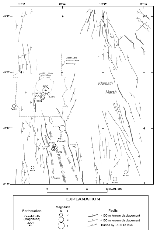
FIGURE 4.—Map showing earthquake epicenters and magnitudes. Base from figure 1. See Bacon and Nathenson (1996, table 2) for data sources. Note that accuracy of epicentral locations varies widely. Earthquakes occurring in 1993 and subsequent years are more accurately located than prior events. Depths of earthquake hypocenters also vary significantly and are not precisely known for most events. Because faults are inclined, earthquake epicenters that do not coincide with specific mapped faults nevertheless may have occurred on a known fault zone.
The consistency in age and amount of displacement on its various faults suggests that the WKLFZ merges at depth into a single through-going structure. The subparallel Sky Lakes fault zone cuts older lavas ~6–8 km west of the WKLFZ. Both of these fault zones pass through Crater Lake National Park and emerge on the north as a ~10-km-wide zone of faulting that has been mapped as far as Mount Bailey (plate 1). The southern boundary of the WKLFZ is marked by a change in strike of faults from north–south to north-northwest–south-southeast (south of the area of fig. 1 and 4, plate 1). The total length of the WKLFZ and its northward continuation, between approximately the latitudes of Pelican Butte and Mount Bailey, is ~70 km, ~50 km if the northern section is not included. Scarp heights in young lavas and moraines suggest that motion on the WKLFZ has occurred in events of a few meters vertical displacement and that large sections of the zone may have moved at once. The WKLFZ is analogous to other active normal fault zones of the Basin and Range province and is capable of producing large earthquakes (e.g., Crone and others, 1991).
Many of the located earthquakes shown in figure 4 occurred within the Klamath graben. Fault planes exposed by quarrying in the Klamath Basin have steep dips (inclinations of ~60° from horizontal) and appear to record mainly vertical (dip slip) displacement. Earthquake epicenters shown in figure 4 may be associated with slip at depth on specific mapped faults, given the direction of dip of the faults, focal depths of earthquakes, and imprecision of earthquake locations. The earthquakes south of Crater Lake National Park and west of latitude 122° may have occurred along the WKLFZ, except the September 21, 1993 event which may have been on the Sky Lakes fault zone (plate 1).