
Fishes and Stream Habitat in Tributaries of the Klamath River in Crater Lake National Park, With Reference to the Sun Creek Bull Trout.

Prepared by
Jeffrey M. Dambacher’
Mark W. Buktenica 2
Gary L Larson3
Oregon Department of Fish and Wildlife
8500 15th Street
Corvallis, Oregon, 97333
National Park Service-
Pacific Northwest Region
Crater Lake National Park
Crater Lake, Oregon, 97604
National Biological Survey
Cooperative Park Studies Unit
College of Forestry
Oregon State University.
Corvallis, Oregon, 97331
December 1993
National Park Service
Pacific Northwest Region
909 First Avenue
Seattle, WA 98104-1060
Introduction
Four salmonid species reside in streams of Crater Lake National Park. Non-native brook trout (Salvelinus fontinalis) and rainbow trout (Oncorhynchus mykiss) and exotic brown trout (SalmQ trutta) were introduced to park streams between 1926 to 1971. Bull trout (Salvelinus confluentus) are considered to be the only fish species native to the park within the Klamath Basin. These four species were also collected during the first comprehensive survey of stream fishes in the park in the summer of 1947 (Wallis 1948).
This study was part of a water-rights adjudication program of the Klamath River. Distribution and abundance of fish in the Klamath River system were considered in the adjudication process. Sun, Annie, Bear and Sand Creeks, which drain the southern and eastern slopes of Mount Mazama in Crater Lake National Park, are tributaries of the Klamath River (Fig. 1). The Sun Creek channel incises a 25,000-year-old glacial valley which was filled with pumice and ash from the eruption of Mount Mazama 6,800 years ago (Bacon 1983). The channel actively erodes the base of the adjacent pumice slopes which supply large amounts of sediment to the stream. Objectives of this study were to:
1. identify the summer distribution and abundance of fishes in Annie Creek, Bear Creek, Sand Creek, and Sun Creek in Crater Lake National Park;
2. define habitats used by the fishes relative to total area and general physical characteristics of stream habitats; and
3. compare channel morphology and the habitat utilized by the fishes at different stream flows.
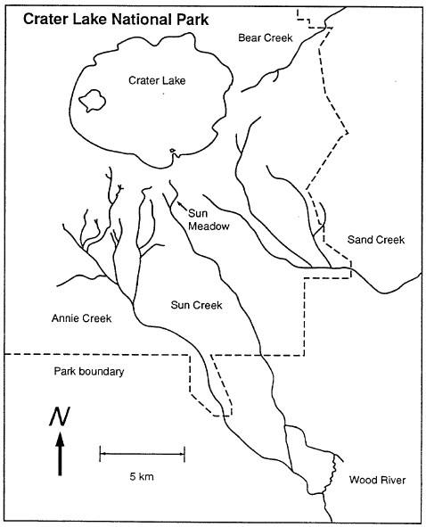
Figure 1. Locations of the four surveyed streams in Crater Lake National Park, Oregon.
Materials and Methods
Habitat Survey
A stream habitat survey was conducted from July through late September, 1989 (Fig. 2) using methods of Hankin and Reeves (1988). Stream channels were divided into three types of habitat units, pools, glides, and riffles (Bisson et al. 1982). In general, pools were relatively deep and had slow current velocities, glides were shallow with even flow, and riffles were shallow with swift, turbulent flow. Length, mean width, and mean depth of each habitat unit was visually estimated. Measurements were made of length, width, and depth in approximately one tenth of all habitat units. These measurements were used to calculate calibration factors to correct visual estimates of habitat area. Lengths were measured along an upstream-downstream transect through the middle of each habitat unit. Widths were measured at three transects across a habitat unit and located at positions that were considered to represent the general variability of the unit. These values were averaged for each unit. Depths were measured across the stream channels at three or more points equally spaced along these transects. Reaches were distinguished based on fish distribution and differences in channel morphology, such as channel gradient, roughness, and composition of habitat units.
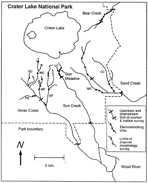
Figure 2. Limits of habitat, channel morphology, and snorkel surveys (summer 1989), and location of electrofishing sites (summer 1989 and 1990) in Klamath River tributaries in Crater Lake National Park. CC: Cavern Creek, EF: East Fork Annie Creek, MF: Middle Fork Annie Creek, MC: Munson Creek, GC: Goodbye Creek, PB: Pole Bridge Creek, VC: Vidae Creek, WC: Wheeler Creek.
Substrate in all habitat units was characterized by the sediment sizes that dominated the wetted channel. The most abundant size class by area was called the dominant; the next most abundant was called the co-dominant. Size classes were: massive boulder (>200 cm), large boulder (> 100 cm), medium boulder (>50 cm), small boulder (Ž25 cm), large cobble (Ž12 cm), small cobble (Ž6 cm), very coarse gravel (>3 cm), course gravel (Ž1.5 cm), medium gravel (>0.8 cm), fine gravel (Ž0.4 cm), very fine gravel (>0.2 cm), sand and silt (<0.2 cm) and bedrock ( Lane 1947). For dominant and co-dominant size classes, the area of each habitat unit assigned to these sediment size class was summed. The total area (dominant plus co-dominant) for each size class was then averaged and expressed as percent dominance (D):
![]()
For example, a channel with coarse gravel substrate dominating 2 percent and co-dominating in 18 percent of the total unit area received a dominance value of 10 percent Dominance values were not synonymous with percent area of the stream channel but represented an average of two sets of proportions drawn from the same channel area.
The number of pieces of woody debris in each habitat were recorded. Woody debris was assigned to the following size categories: < 0.1 Di, 0.1 to 0.19 m, 0.2 to 0.29 m, 0.3 to 039 m, 0.4 to 0. 79 m, and > 0.79 m.
Materials and Methods
Fish Population Estimates
Each stream survey began at the park boundary and progressed upstream into the tributaries until fish were judged to be in low abundance or absent (Fig. 2). Estimates of fish abundance were made by direct observation by a single snorkel diver in 10 percent (every tenth unit of a habitat type) of all habitat types, except in Sun Creek where 20 percent of the pools (every fifth pool) were surveyed. These counts were extrapolated to estimate the total number of fish in each stream (Hankin & Reeves 1988). A flashlight was used to illuminate shaded areas beneath undercut banks and woody debris.
Age classes of fish based on measured body length were: < 60 mm, age 0; 60 – 100 mm, age 1; > 100 mm, age 2 and older. Brook and bull trout hybrids were identified by spots on dorsal fins and often by small vermiculation patterns on dorsal flanks and weak tri-coloration on pectoral and pelvic fins (fins with slight or no orange cast and a black stripe next to a white leading edge). Bull trout had solid-colored fins and lacked body vermiculations. Brook trout as small as 50 mm were distinguished from bull trout by dorsal fin vermiculations.
In Sun Creek, the position of each fish in the channel was assigned to one of three locations: (1) mid-channel without cover; (2) mid-channel in lee of cover; (3) and channel edge. Cover was considered to be any obstruction to stream flow, e.g., woody debris and larger than average substrate.
Fish collected using electroshocking were compared with the number of fish counted during snorkel counts in Sun Creek. Ideally, ten or more comparisons were needed to calculate reliable correction factors for abundance estimates based on snorkel counts (Hankin & Reeves 1988). Only a single 70 m section of stream channel was successfully electroshocked in a rigorous manner. Other electroshocking efforts met with failure due in part to logistical problems and equipment failure. In the 70 m section, three brook trout and eight bull trout were estimated from electroshocking, whereas two brook trout and nine bull trout were estimated from diving. Other less-precise electroshocking comparisons were in general agreement with the dive counts, although in some instances, abundance of age-1 brook trout were underestimated. Because there were no reliable estimates of dive count errors, visual estimates of fish numbers in all streams were not adjusted and should only be considered as relative estimates of population size.
Electroshocking was used to sample selected sites to verify presence or absence of fish and to give a general impression of fish abundance in reaches not surveyed by snorkel diving. Three categories were used to describe fish abundance from snorkel diving and electroshocking surveys: high abundance – > 5 fish per habitat unit; moderate abundance – 2-5 fish per habitat unit; and low abundance – <2 fish per habitat unit.
Ivlev’s electivity index (Ivlev 1961) was used to describe habitat utilization by the fishes. The index in this application was defined as:
![]()
where E was the value of electivity, r was the proportion of fish in a habitat type i and p was the proportion of the area in habitat type i The index had a possible range of -1 to + 1 and was asymptotic towards its extremes. Negative values indicated avoidance, positive values indicated preference, and values near zero indicated no selection.
Results
SUN CREEK
Habitat Characteristics
The lower 11 km of Sun Creek were divided into lower (6.6 Iom), middle (1.9 Im), and upper reaches (2.4 km) based on the distributions of brook trout and bull trout (Figure 3). These three reaches received complete habitat and fish population inventories. Channel substrate was coarser in the middle and upper reaches (Figure 4). The mean size of dominant substrate increased from medium gravel in the lower reach to small cobble in the middle and upper reaches. Sand and finer sediments were actively transported at all flow levels observed from June to October, and all crevices in the channel were embedded with fine sediments.
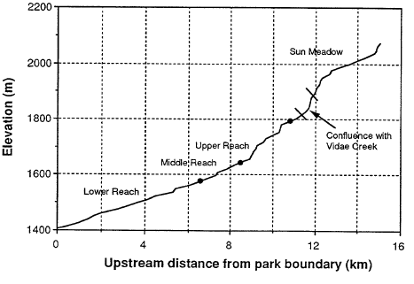
Figure 3. Longitudinal profile and map of each study reach in Sun Creek, Crater Lake National Park, Oregon. Filled circles denote reach boundaries, and the cross lines denote the area of impassable falls.
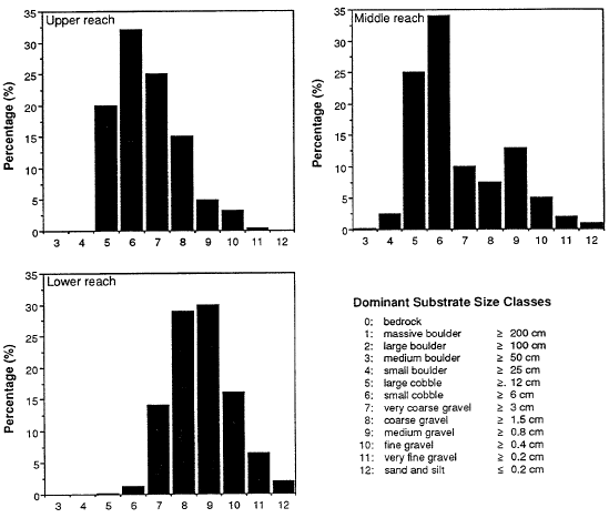
Figure 4. Dominant substrate in the three main study reaches of Sun Creek, Crater Lake National Park, Oregon, 1989. Sediment size classes from Lane (1947).
Of the 49,760 m2 of habitat inventoried in Sun Creek, 72 percent occurred in the lower, 13 percent in the middle, and 15 percent in the upper reach (Table 1). Riffle habitat increased in area as the channel gradient increased from the lower to the upper reach. The three reaches contained relatively high densities of woody debris (Figure 5). The smallest pieces (0.1 m) occurred in the greatest density. The middle reach contained the highest densities of pieces less than 0.4 m in diameter.
Table 1. Number, area, and volume of habitat unit types in three reaches of Sun Creek, Crater Lake National Park, summer 1989.
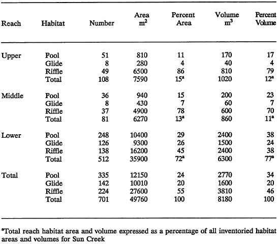
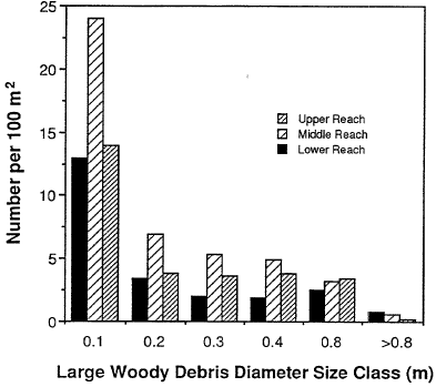
Figure 5. Density of woody debris pieces in three reaches of Sun Creek, Crater Lake National Park, Oregon, 1989.
Woody debris supplied by fallen trees in the active channel controlled the majority of channel structure in Sun Creek. Most breaks in channel gradient were controlled by woody debris pieces, and practically all pools and scour pockets were formed by flow that was either constricted, diverted, or pooled by the debris. Undercuts were a major feature along the banks of the stream and these were supported by either woody debris or tree roots. This wood material appeared to be stationary after it entered the stream.
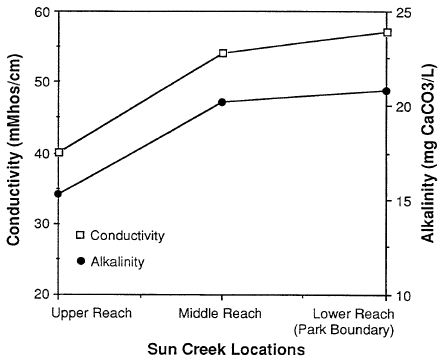
Figure 6. Conductivity and alkalinity of three locations in Sun Creek, Crater Lake National Park, August 31, 1989.
Alkalinity and conductivity were similar in the middle and lower reaches but substantially lower in the upper reach of Sun Creek (Figure 6). This was likely a result of proportionately more flow from deep pumice aquifers in the middle and lower reaches. The majority of water in the upper reach originated from surface snowmelt or groundwater flowing through the thin soils which overlay the flanks of Mount Mazana. Ferric hydroxide flocculent (orange colored) covered the banks near spring seeps and the stream bottom for a distance of 1.6 kin, which spanned the upper 1.1 km of the lower reach and the first 0.5 km of the middle reach. Water in this section, and a few kilometers downstream, had a strong metallic taste.
Fish Distribution and Abundance
The upper, middle and lower reaches of Sun Creek received complete fish population inventories. Fish populations in reaches further upstream were sampled by electroshocking. Brook trout and a few brook x bull trout hybrids were found in the first 6.6 km of stream (lower reach). Bull trout, brook trout, and hybrids were collected from 6.6 km to 8.5 km (middle reach). Only a few brook trout and hybrids were observed in the upper 2.4 km of the surveyed channel (upper reach). No fish were found in Vidae Creek and adjoining tributaries (Figure 7). Brook trout were in moderate abundance in the uppermost portion of Sun Creek, known as Sun Meadow, from approximately 03 km downstream and 0.8 km upstream from a road crossing a picnic area. Only a few brook trout were found from the confluence of Vidae Creek and Sun Creek to within 0.31 km downstream from the road crossing in Sun Meadow.
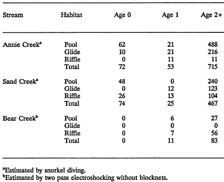
Based on snorkel dive counts, there were 2,265 age-1 and age-2+ fish in the three surveyed reaches of Sun Creek (Table 2). Brook trout made up approximately 93 percent (2,101 fish), bull trout 6 percent (133 fish), and brook x bull trout hybrids 1 percent (31 fish) of the total number. Hybrids totaled about 19 percent of bull trout and hybrids combined (164 fish).
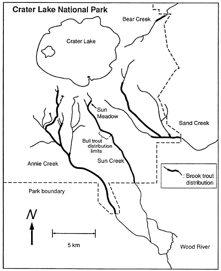
Figure 7. Distribution of brook trout (thick lines) and bull trout (see note for Sun Creek) in Crater Lake National Park, for four Klamath River tributaries, summer 1989.
Table 2. Numbers, by habitat type, of brook and bull trout, and brook x bull trout hybrids estimated by snorkel diving in the three reaches of Sun Creek, Crater Lake National Park, summer 1989.
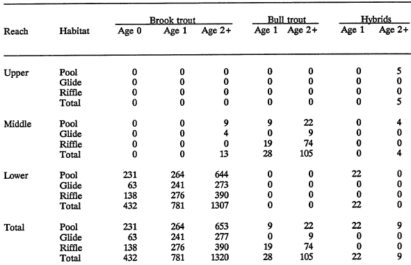
Table 3. Density (number/lO00m2 ) of brook trout and bull trout by habitat type in streams of Crater Lake National Park, summer 1989.
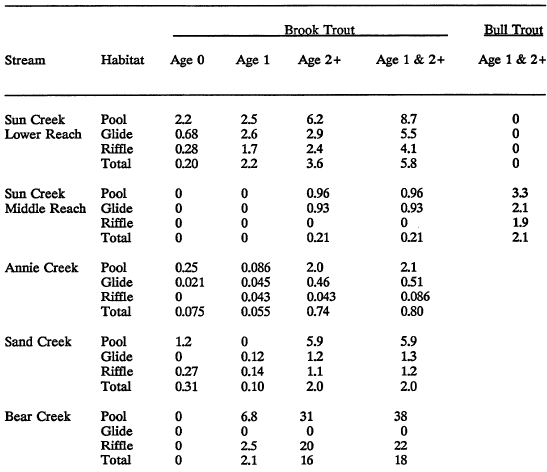
The density of brook trout in the lower reach (5.8 fish/lOOm2) was about 2.5 times greater than those of both bull and brook trout combined in the middle reach (23 fish/lOOm2; Table 3). The density of age-1 and age-2+ bull trout in the middle reach was about 10 times that of brook trout. The highest densities of fish in all reaches occurred in pools, intermediate densities occurred in glides, and lowest densities were in riffles. Estimates of the densities of small fish in low abundance from a subsample of less than 20 percent of the habitat units in a reach should be regarded with caution. For example, only one hybrid was counted while snorkel diving in the middle reach, whereas hybrids made up about 24 percent of the total number of bull trout and hybrids in the 0.5-km reach sampled by electroshocking. Similarly, in the same 0.5-km section the number of brook trout was half the number of bull trout based on electroshocking sample, whereas based on the snorkel diving, brook trout were approximately one tenth as abundant as bull trout. The estimated numbers of age-O and age-I brook trout in the lower reach were suspiciously low in comparison to age-2+ brook trout (Table 2). This result might indicate an inverted age class structure. However, it is likely that many fish of age 0 and 1 were missed during snorkel counts, and their actual abundances were probably greater than estimated. The relative differences in the number of fish among the reaches and between fish species were quite large and not likely the result of estimation error.
Habitat Utilization
Bull trout and brook trout utilized similar habitats in Sun Creek. At the level of the habitat unit, both species preferred pools (Table 4). Age-2+ brook trout utilized pool habitat more than did age-1 fish. At the micro-habitat level, the majority of all age classes of both species maintained positions at the channel edge (Figure 8). Utilization of the mid-channel increased with age. Age-O brook trout positioned themselves exclusively at the channel edge. When brook and bull trout were observed in the same pool, brook trout occupied the center of the pool, and bull trout occupied the downstream end and the margins of the pools. Under allopatric conditions, the largest (age-2+) fish of either species were observed to occupy the center of pools.
Table 4. Habitat electivity E (Ivlev 1968) of brook trout and bull trout in streams of Crater Lake National Park, summer 1989. E has a possible range of -1 to + 1; negative values indicate avoidance, positive values indicate preference, values near zero indicate neutral selection.
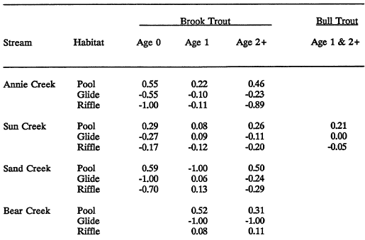
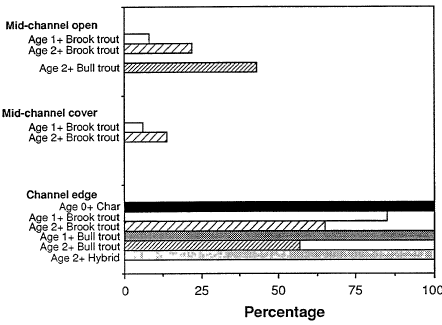
Figure 8. Frequency of microhabitat choice by bull and brook trout in Sun Creek, Crater Lake National Park, Oregon, as observed by snorkel diving, summer 1989; number of fish in parentheses.
Fish Length and Weight
Bull trout weighed less than brook trout of the same length (Figure 9). Bull x brook trout hybrids were similar in weight to bull trout of the same length. Brook trout in the middle reach attained the same weight for a given length as those in the lower reach. Thus, even though fish densities were six times less in the middle reach than in the lower reach, brook trout attained the same level of condition in both reaches.
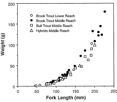
Figure 9. Length versus weight of bull trout, brook trout, and brook and bull trout hybrids in Sun Creek, Crater Lake National Park, summer 1989.
Results
ANNIE CREEK
Habitat Characteristics
The mainstem of Annie Creek, from the park boundary to its confluence with Munson Creek, was divided into seven reaches based on differences in channel morphology (Table 5, Figures 10 and 11). All reaches had channel profiles that were controlled in part by large fallen trees. All reaches generally contained equal densities of woody pieces (Figure 12).
The first three reaches occurred within a transition zone from a narrow canyon to the broad Wood River Valley known as the “panhandle”. Reaches 1 and 3 were
Table 5. Number, area, and volume of habitat unit types in seven reaches of Annie Creek, Crater Lake National Park, summer 1989.
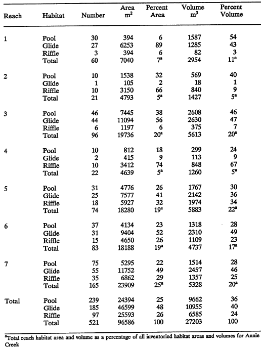
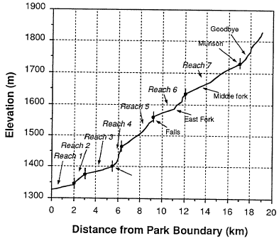
Figure 10. Longitudinal profile of Annie Creek, Crater Lake National Park; from 1:24,000 scale USGS map. Filled circles denote reach boundaries.
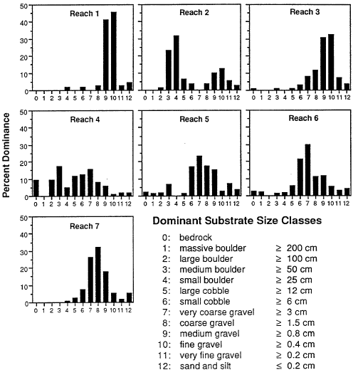
Figure 11. Dominant substrate in seven reaches of Annie Creek, Crater Lake National Park, 1989. Sediment size classes after Lane (1947).
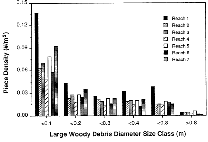
Figure 12. Density of wood debris pieces in seven reaches of Sun Creek, Crater Lake National Park, 1989.
dominated by glide habitat and gravel substrate (Table 5). Reach 2 was dominated by riffle habitat and boulder substrate. The stream channel in these three reaches meandered across a terraced valley floor bounded by forested hillslopes. The width of the valley floor decreased from about 60 m in reach 1 to about 20 m in reach 3. Upstream from reach 3, the stream was relatively straight, being confined by steep hillslopes and canyon walls. In reach 4, the stream was confined to a 10-m-wide valley floor by sheer rock walls. This was the steepest reach surveyed in Annie Creek, and it was dominated by riffle habitat and boulder and cobble substrate. Reach 5 also was narrowly confined by the rock canyon, but it had less channel gradient than reach 4. Reach 5 was dominated by glide habitat and cobble and gravel substrate. In reach 6, the valley floor was bounded by forested hillslopes and bedrock outcrops, and it varied in width between 20 m and 40 m. Major breaks in gradient were controlled by bedrock falls; Annie Falls was the largest of these. The seventh reach was dominated by glide habitat and gravel substrate. The valley floor varied in width between 20 m and 60 m and was confined between steep forested hillslopes. Fallen trees had a major influence on the channel profile in reach 7.
Fish Distribution and Abundance
The estimated number of age-1 and age-2+ brook trout in the mainstem of Annie Creek was 768 (Table 6). One rainbow trout was observed 0.42 km upstream from the park boundary and four brown trout were observed in the lower 13 km of the stream within the park. Only a few age-0 brook trout were observed by snorkel diving. Sixty-eight percent of the observed fish were in pools.
Based upon electroshocking results, no fish were found in Pole Bridge Creek, and Goodbye Creek Creek (Figures 2 and 7). The middle and east forks of Annie Creek and Munson Creek near the headquarters of Crater Lake National Park could not be electrofished in September because the electroshocking unit was not working properly. Thus, additional electrofishing was conducted in these sections of Annie Creek drainage in the summer of 1990. Munson Creek was found to be sparsely populated by brook trout, whereas the lower half of the middle fork of Annie Creek had a moderately abundant population of brook trout (Figure 7). No fish were found in the East Fork of Annie Creek in 1990. An absence of fish near the mouth of the East Fork of Annie was also noted in the summer of 1989 while snorkel diving the lower 0.5 km of stream. A water
Table 6. Estimated numbers of brook trout in surveyed portions of three streams of Crater Lake National Park, summer 1989.
fall approximately 10 m high just upstream of the mouth of the east fork of Annie Creek was a barrier to fish migration. Furthermore, there was no record of fish stocking in the East Fork of Annie Creek (Wallis 1948).
Results
SAND CREEK
Habitat Characteristics
Sand Creek was surveyed most intensively for approximately 5.5 km from the park boundary to the base of a 360-m-long cascade and less intensively upstream from the cascade (Figure 13). Two reaches were identified below the cascade on Sand Creek and two reaches were identified upstream from above the cascade (Figure 13). Reach 1 was dominated by glide habitat and fine and medium gravel size substrate (Table 7, Figure 14). The substrate was not large enough to control the channel profile. All channel units and all controls of channel profile were formed by pieces of fallen trees (Figure 15). Riffles in this reach were formed by many small steps created by pieces of fallen trees across the channel. The valley floor was 40 m to 80 m wide and confined by steep slopes, which were either forested or covered by exposed pumice soil and isolated spires of pinnacle formations. The stream meandered across the valley floor and created eroding cut-banks that supplied large amounts of fine sediments to the channel.
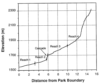
Figure 13. Longitudinal profile of Sand Creek, Crater Lake National Park; from 1:24,000 scale USGS map. Filled circled denote reach boundaries.
Reach 2 was dominated by riffle habitat and substrate was small cobble to very coarse gravel (Table 7, Figure 14). Channel structure in this reach was controlled by fallen trees and cobble substrate (Figure 15). The valley floor was 10 to 15 m wide. Adjacent hillslopes were forested, but compared to reach 1, exposed pumice soil and pinnacle spires were more prevalent. Many of the pinnacle spires had fallen into the stream channel and created scour pools, dam pools, and cascades. This reach ended at the base of the 360-mlong cascade.
Upstream from the cascade, reach 3 was incised into a narrow canyon of welded tuft. Although there was no extensive habitat survey, this reach was generally dominated by riffle habitat and cobble-and-gravel-sized substrate. Only a few fallen trees were in the channel. The channel profile was predominantly controlled by bedrock, large boulders, and cobbles composed of welded tuft.
Reach 4 was in a broad plane of mounded terraces above the canyon formed by pinnacle formations. The stream channel was dominated equally by riffle and pool habitat and the substrates were primarily gravel sized. Fallen trees formed the majority of pools, whereas riffles were composed of a mix of cobble and gravel-size substrate.
Table 7. Number, area, and volume of habitat unit types in two reaches of Sand Creek, Crater Lake National Park, summer 1989.
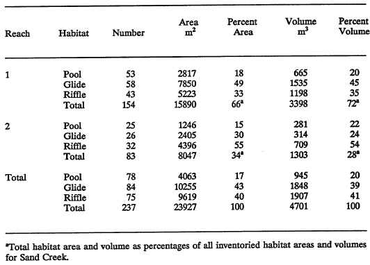
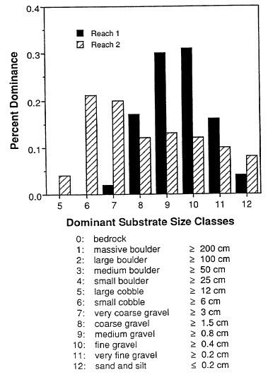
Figure 14. Dominant substrate in two reaches of Sand Creek, Crater Lake National Park, 1989. Sediment size classes after Lane (1947).
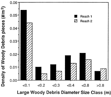
Figure 15. Density of woody debris pieces in two reaches of Sand Creek, Crater Lake National Park, 1989.
Fish Distribution and Abundance
A total of 25 age-1 and 467 age-2+ brook trout were estimated to be in Sand Creek in the lower two reaches that were surveyed (Table 6). The majority of these fish were observed in pools. Based on electroshocking, brook trout were present 5.5 km upstream from the 360-m-long cascade. Brook trout in Wheeler Creek and Cavern Creek (Figure 7) were restricted to reaches downstream from steep, and what appeared to be, impassable channels. Presumably these brook trout immigrated from Sand Creek because there were no records of stocking in these streams. Numerous brook trout were found in Lost Creek. This stream has surface flow for approximately 2 km before flowing subsurface.
Results
BEAR CREEK
Habitat Characteristics
Bear Creek, from the park boundary to approximately 3.5 km upstream was divided into three reaches (Figure 16). Glide and riffle habitat dominated the three reaches and the stream bed was composed of sand and gravel-sized substrate (Table 8, Figure 17). The channel was incised into a small “V”-shaped valley of loose pumice soil. Adjacent hillslopes were covered by lodge-pole pine, which were largely dead and fallen from an infestation of bark beetles. The channel profile and morphology were controlled by pieces of the fallen trees (Figure 18). All breaks in gradient were associated with limbs and trunks of fallen trees.
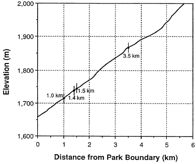
Figure 16. Longitudinal profile of Bear Creek, Crater Lake National Park; from 1:24,000 scale USGS map. Filled circles denote reach boundaries.
Table 8. Number, area, and volume of habitat unit types in three reaches of Bear Creek, Crater Lake National Park, summer 1989.
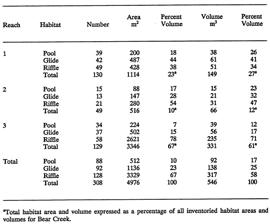
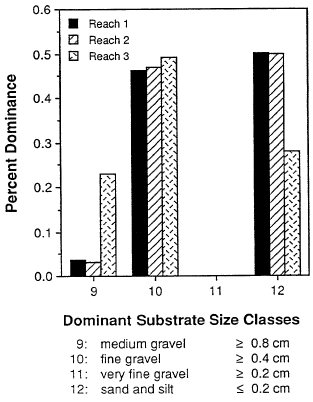
Figure 17. Dominant substrate in three reaches of Bear Creek, Crater Lake National Park, 1989. Sediment size classes after Lane (1947).

Figure 18. Density of woody debris pieces in three reaches of Bear Creek, Crater Lake National Park, 1989.
Fish Distribution and Abundance
Brook trout in Bear Creek were confined within 0.4 km of channel (reach 2), starting 1.0 km from the park boundary (Figure 7). The population was constrained by intermittent flow in reach 1 and by a small dam located 90 m upstream in reach 3. The 3-m-high woodplank dam was backfiled with sediment.
The estimated number of age-I and age-2 brook trout in Bear Creek was 91 (Table 6). This population estimate was based on adding the total fish captured from two passes with an electroshocker (blocknets were not used) in 10 percent of the habitat units because the stream was too small for effective snorkeling. Fish abundance determined from this crude method should be considered as a minimum population estimate. Most fish were captured in riffle habitat.
Results
Densities and Habitat Electivity in Sun, Annie, Sand and Bear Creeks
Bear Creek had the highest fish density of all streams surveyed (Table 3), whereas the density of fish in Sand Creek was more than twice that of either Annie Creek or Sun Creek. Brook trout in Sun Creek, Annie Creek, Sand Creek, and Bear Creek generally exhibited a high preference for pool habitat (Table 4). Compared to age 2+ fish, however, age-1 brook trout showed a greater utilization of glide and riffle habitat.
Discussion
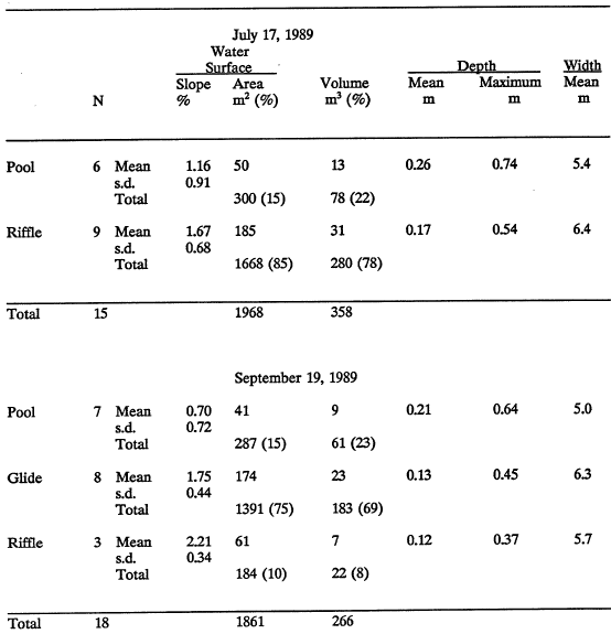
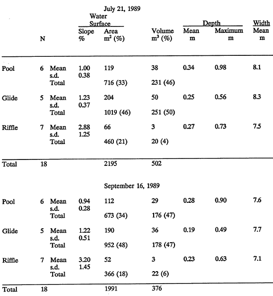
One objective was to compare the habitat utilized by fish relative to stream channel morphology and discharge. Although the range of stream flows during these studies was probably too narrow to assess all of the important flow-related changes in stream habitat characteristics, some initial results were obtained. Pools, which were the preferred habitat of both brook trout and bull trout, did not appear to change in availability and general dimensions under the two flow regimes. In Sun Creek, however, the net increase in the number of glides was balanced by a loss of riffles. This change in habitat may have favored brook trout slightly because glides were preferred over riffles. In contrast, bull trout exhibited nearly neutral selection of glides and riffles. The survey techniques employed, however, only addressed changes in the characteristics and composition of habitat at the unit level. Habitat as expressed by stream volume, decreased by 25 percent from July to September.
Park stocking records reported by Wallis (1948) indicate that approximately 45,000 brook trout fry and 7,000 rainbow trout fry were introduced into Sun Creek (Figure 19). Wallis (1948) overlooked the rainbow trout stocking record and mistakenly concluded that rainbow trout were native to the park (see Wallis 1948, pages 40, 55, and 104). Sand Creek, Bear Creek, and Annie Creek may have been fishless prior to the introduction of non-native salmonids into park streams (Wallis 1948).
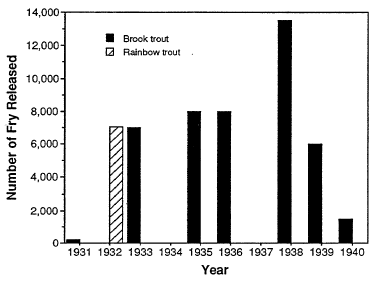
Figure 19. History of trout introductions into Sun Meadow of Sun Creek, Crater Lake National Park, 1931 to 1947. Fish released at lengths of 50 to 75 mm.
Wallis (1948) noted that bull trout were “well distributed” in Sun Creek downstream from a falls located about 0.7 km downstream from the confluence of Vidae Creek and Sun Creek in 1947. The bull trout population was restricted to a 1.9-km-long reach in 1989. Interspecific competitive interactions and hybridization with brook trout are probably the principal mechanisms that have restricted distribution and reduced abundance of bull trout in Sun Creek (Ratliff 1992). Hybridization with brook trout is likely a great detriment to the reproductive capacity of the bull trout population in Sun Creek because previous research found that brook x bull hybrids were infertile males (Leary et al. 1983). Hence, a hybrid is a loss to the gene pool of the population. However, a hybrid female with developed ovaries (Markle 1991) was collected from the middle reach of Sun Creek in 1989. It is not known if the hybrids in Sun Creek are capable of producing viable offspring.
Survival of bull trout to emergence in Sun Creek is probably low owing to the great amount of fine pumice sediment in the stream bed (Shepard et al. 1984). Bull trout recruitment in the middle reach of Sun Creek may also be limited owing to a lack of spawning gravel.
The status of the bull trout population in Sun Creek should be considered precarious at best. In addition to the noted impacts caused by competitive interactions and hybridization between bull trout and brook trout, variation in population abundance as great as 500 percent from random perturbations in the environment are common among stream fishes (Hall and Knight 1981). It seems reasonable to be concerned about the long-term well being of the Sun Creek bull trout population owing to its restricted distribution, low abundance (133 fish), and sympatry with brook trout.
Acknowledgements
The authors sincerely thank Warren Griffin for his dedicated field work. This study was supported by funding from the Water Rights Branch of the National Park Service Water Resources Division. Cindy Alexander and Becca Nightingale typed and Ruth Jacobs edited the manuscript.
Other pages in this section
*** previous title *** --- *** next title ***