
Boundary Springs Trail – Crater Lake National Park
Time: 2.5 hours
Difficulty: Moderate
Length: 2.5 mi (4.02 km)
REI Trails Project partners with Crater Lake Institute to produce their trails app. Click the map below, get the app – then come back, we offer more. View all trails here.
| |
Elevation: 5233* – 5328 ft (1595* – 1624 m)
Difficulty: Moderate
Length: 1.93 mi (3.11 km)
Elevation: 5643* – 5545† ft (1720* – 1690† m)
Elevation: 5233 ft (1595 m)
Trailhead coordinates:Latitude: N +43° 05.45 or 43.09084
Longitude: W -122° 13.28 or -122.22141
Altitude: 5233* ft (1595* m)
*Highway 230 turnout Boundary Springs
Highlight: springs, streams, wildflowers
Trail Description:
This easy-to-moderate walk is to the headwaters of the Rogue River is fairly flat. After leaving the Hwy 230 turnout/parking area, you will pass through a fairly open forest stand of lodgepole pine, mountain hemlock, and shasta red fir. The trail follows the narrow Rogue River canyon until it ends at a wet meadow fed by the Boundary Springs. Note that after a mile, approximately, the trail intersects a Forest Service road, also the Upper Rogue River trail. Turn right and head up the road for about 100 feet before turning left, back onto the Boundary Springs trail.
Trailhead Location: Pullout on Highway 230 near milepost 19, 5 miles (8 km) west of the junction with Highway 138. Although much longer, Boundary Springs can also be reached through the park via a southern trail that connects with the Bald Crater Loop Trail and then the Pacific Crest Trail.
Nature Note: Snowmelt, not Crater Lake, is the source of Boundary Springs’ water. Boundary Springs on the north boundary forms the headwaters of the Rogue River. These waters spring forth most unexpectedly from the otherwise-arid ground of the area, splash downward over the irregular terrain into a stream which leads north away from the park, producing an aquatic scene of great esthetic appeal.
Seasonal Information: Expect the trail to be covered in snow from October to early July, however, conditions vary somewhat from year to year. See Crater Lake Current Conditions for more information.
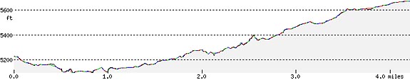
Boundary Spring Trail Elevation Profile
Related Maps
Digital USGS topographic maps (PDF files) – the following maps are relevant to the Boundary Spring trail. See more Crater Lake Institute online USGS digital maps.
| Series | Name | Year | Scale | Contour Interval | File Size |
| USGS 7.5′ | Pumice Desert West | 1985 | 1:24,000 | 40 ft | usgs-pumice-desert-west-7.5 |
| USGS 30′ x 60′ | Crater Lake | 1989 | 1:100,000 | 50 m | usgs-crater-lake-30-minute |
| USGS 30′ x 60′ | Diamond Lake | 1978 | 1:100,000 | 50 m | usgs-diamond-lake-30-minute |
| USGS 1° x 2° | Klamath Falls | 1970 | 1:250,000 | 200 ft | usgs-klamath-falls-1-2 |
| USGS 1° x 2° | Medford | 1976 | 1:250,000 | 200 ft | usgs-medford-1-2 |
| USGS 1° x 2° | Roseburg | 1970 | 1:250,000 | 200 ft | usgs-roseburg-1-2 |
|
Please remember to practice “leave no trace outdoor ethics” when you are out on Crater Lake National Park’s trails…and have fun! |
***previous*** — ***next***