
Dutton Creek Trail – Crater Lake National Park
| Difficulty: Moderate
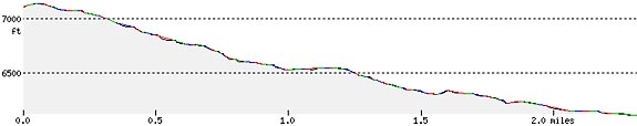
Length: 2.5 mi (4.0 km) Elevation: 6109* – 7123 ft (1862* – 2171 m) |
Trailhead coordinates:Latitude: N +42° 54.71 or 42.91191
Longitude: W -122° 08.03 or -122.14720 Altitude: 7123 ft (2171 m) |
| Highlight: old mountain hemlock forest, high-elevation mountain stream | |
*Dutton Creek Campground
REI Trails Project partners with Crater Lake Institute to produce their trails app. Click the map below, get the app – then come back, we offer more.
Trail Description
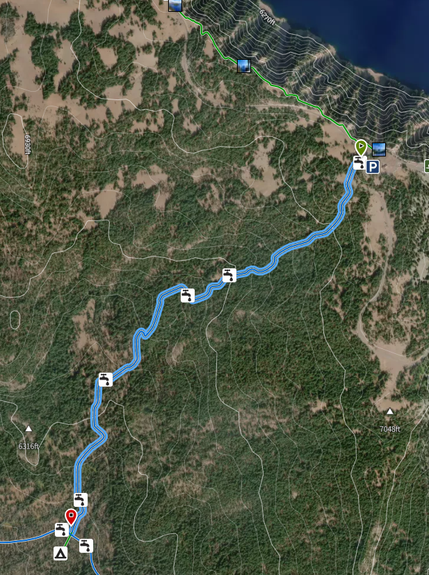
The Dutton Creek Trail is also now the beginning portion of the new alternative Pacific Crest Trail. This trail runs northeast to southwest (top to bottom) on the opposite side of the Munson Ridge from the main Munson Valley entrance corridor to Crater Lake.
The first few hundred meters of the trail run from the Munson Valley road/West Rim Drive Junction at the west end of the Rim Village downward between the Munson Valley road and the beginning of the Dutton Creek drainage.
The trail is a steady descent along Dutton Creek with some stream crossings in the first mile. The first 1.25 miles is the steepest portion. After this the trail becomes less steep with a few, nearly flat, portions. About 1.25 miles from the trailhead, there is a small tributary to Dutton Creek where you will find a camping area. After this camping area is a more steady descent for another mile. The trail reaches the Pacific Crest Trail in a wet and flat area 2.5 miles from the trailhead. Just south of this junction is a second backcountry camping area.
Trailhead location: Directions from Annie Spring Entrance Station: Drive northward into the park 4 miles to Rim Drive. Turn left on to West Rim Drive and travel 2 miles to Rim Village Road. Turn right and drive a short distance to the trailhead. The Dutton Creek Trail can be accessed via the Discovery Point Trail. From the junction of Rim Village Road and West Rim Drive the trail leads southwestward on the opposite side of Rim Drive from the Discovery Point Trail.
Nature Note: The trail’s upper section is composed primarily of an old mountain hemlock forest and near the bottom a more open stand of lodgepole pine comes to dominate. Intermixed, in the bottom section of the trail, are some open grassy meadows.
Historic Note: This trail is named for Captain Clarence E. Dutton who was the chief of the United States Geological Survey group that first took soundings of Crater Lake’s depth in 1886. Also, this trail was originally an old wagon trail used by the park’s first visitors to reach the rim of Crater Lake.
Seasonal Information: Expect the trail to be covered in snow from October to early July, however, conditions vary somewhat from year to year. See Crater Lake Current Conditions for more information.
Dutton Creek Trail Elevation Profile
Related Maps
Digital USGS topographic maps (PDF files) – the following maps are relevant to the Dutton Creek trail. See more
| Series | Name | Year | Scale | Contour Interval | File Size |
| USGS 7.5′ | Crater Lake West | 1985 | 1:24,000 | 40 ft | usgs-crater-lake-west-7.5 |
| USGS 30′ x 60′ | Crater Lake | 1989 | 1:100,000 | 50 m | usgs-crater-lake-30-minute |
| USGS 30′ x 60′ | Diamond Lake | 1978 | 1:100,000 | 50 m | usgs-diamond-lake-30-minute |
| USGS 1° x 2° | Klamath Falls | 1970 | 1:250,000 | 200 ft | usgs-klamath-falls-1-2 |
| USGS 1° x 2° | Medford | 1976 | 1:250,000 | 200 ft | usgs-medford-1-2 |
| USGS 1° x 2° | Roseburg | 1970 | 1:250,000 | 200 ft | usgs-roseburg-1-2 |
|
Please remember to practice “leave no trace outdoor ethics” when you are out on Crater Lake National Park’s trails…and have fun! |
Other pages in this section
- Pacific Crest Trail
- Anderson Bluffs Trail
- Anne Creek Canyon Trail
- Anne Springs Cutoff Trail
- Bald Crater Loop Trail
- Bert Creek Trail
- Boundary Springs Trail
- Castle Crest Wildflower Trail
- Cleatwood Cove Trail
- Crater Peak Trail
- Discovery Point Trail
- Fumarole Bay Trail
- Garfield Peak Trail
- Godfrey Glenn Trail
- Lightning Spring Trail
- Llaos Hallway
- Mount Scott Trail
- Park Headquarters Historic Trail
- Pinnacles Valley Trail
- Plaikni Falls Trail
- Pumice Flat Trail
- Stuart Falls Trail
- Sun Notch Trail
- Union Peak Trail
- Watchman Peak Trail
- Wizard Island Summit Trail
- Hiking Rules and Regulations
- Best Trails at Crater Lake